To next page
Ibn-Hawqal (970) from Baghdad. (Kitab Surat al-Ardh) (the shape of the earth).
--------------------------------------------------------------------------------
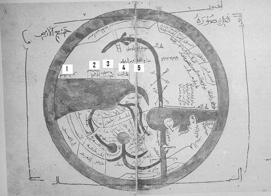
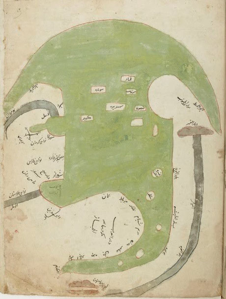
The sources of the Nile also taken out of a Persian translation of Ibn Hawqals book.
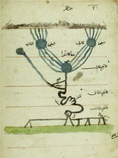
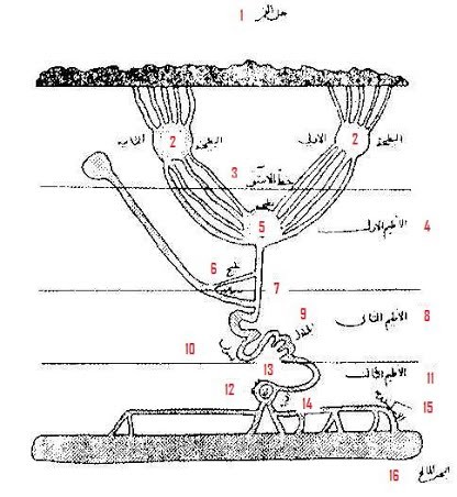
1 Mountain Qumr
2 first lake, second lake
3 equator-line
4 first climate
5 lake
6 arm
7 capital of Nubia
8 second climate
9 Cataracts
10 Assouan
11 third climate
12 Misr
13 Djazira
14 Guizeh
15 Alexandrie
16 the sea
Taken from the French translation ; Configuration de la Terre.
Also extracts from: - Marcel Devic; Le pays des Zendjs
One of his travels brought him 20 degrees south of the equator (Sofala) along the African coast. One of the things he noted was that there were large numbers of people living in areas that the Greek said were uninhabitable.
P9-10
I don't mention the countries of the blacks in the Maghreb, nor the Buja (1), nor the Zendjs, not the other groups living in their neighborhood, because the good organization of the empires comes with religious convictions, good morals, and wise institutions, and the conservation of wealth depends on a just method of government. Or those ones neglect those qualities or they do not participate in them and so need a different place from the viewpoint of the development of the other empires.
P12
As to the largeness of the land-area, from the extreme north to the southern limit, it starts beginning from the coast of the Ocean to come to the territory of Gog and Magog (2), passing through the territory of the Slaves, passing the region of the interior slaves Bulgares, and the Slaves, further on the country of the Byzantins, the land of Egypt, and Nubia, stretches through the deserts between the lands of the Blacks and the Zendjs, to finish up at the Ocean....
Between the land of the blacks and the (surrounding) ocean in the south is a desert where the enormous heat destroys all live. Just like the cold has destroyed all live between the Northern Ocean and the lands of Yadjoudj and Madjoudj (Gog and Magog).
P13
There are Gulfs in the region of the Zendjs, as well as in the neighborhood of the lands of the Byzantins, where one also has seas, but we will not mention them because they are small in comparison with the other seas, and also because there are so many....
P16
Abyssinie stretches along the Red sea, which is in reality the Persian sea, and which goes up to the land of the Zendjs. From the other side it is limited by the desert situated between Nubia and the Red sea, and another frontier goes along the Buja (1) and the un-passable desert. The territory of the Zendjs is the longest of all the Black countries, it borders the Abyssinians....
(All this he textually copied from Istakhri)
The Indian empire is situated opposite the land of the Zendjs, in the eastern part of the Persian Sea....
P42
Then this sea stretches along the Abyssinian sea, arrives at the end of the land of Nubia to get to the regions of the Zendjs, which are the biggest ones in these areas. After that the sea continues among the countries of Islam…..
P44
At the altitude of Yemen basin, the sea is called sea of Aden, and this up to Aden, then it is called sea of Zendjs, and this opposite Oman where she goes towards the sea of Persia. It is a sea that becomes so large that crossing it to the land of the Zendjs is 700 parasangs. (1980 miles) It's an obscure and dark sea, under its surface nothing is visible. Close to Aden there is a fishing ground for pearls, who are brought to Aden. After passing Oman, passing the limits of Islam, and continuing to Ceylon, this sea takes the name of Persian Sea. She reaches a very big surface. On the opposite shore are the lands of the Zendjs.
P51-52
(An extract out of a battle in upper Egypt between the forces of the emir and the tribal Buja (1):) Qummi also has Koran verses written on banners, put up in an imposing line and attached to the lances, and he has them proclaim in the early morning; look here for you soldiers of the Buja, the messages of the emir of the believers. The Buja were arranged for battle, seeing this, they become curious and several leave the ranks to get closer. Qummi had had put the flags on the camels who carried the drums. When the Buja were among the written banners, the Zendjis start beating the drums, the ranks of the Buja are broken and they flight in disorder. (This might well be one more example of Zanj mercenaries in the Egyptian army.)
P56
The land of Abyssinia ..... After that the territory continues to the land of the Zendjs, situated opposite Aden..... . Those gold mines extend (from Abyssinia) up to the land of the Zendjs along the sea..... Following certain sayings there are in the land of the Zendjs cold regions, in which white Zendjs live (3). I already said that this country is miserable, with few people few little cultivated lands, except for the area around the residence of the king....
P58
The southern ocean.....passes to the south-east of Sama (4) and Ghariwa (5), in a country with innumerable inhabitants, until it reaches the desert which no one has yet crossed. Between the hinterland and the regions of the Zendjs, there are big sand wastes, who formerly were passable, that was the route from Egypt to Ghana....
P103
As for the Banu Tanamak [Berbers], the kings of Tadmakka, and the tribes related to them, it is said that they were originally Sudan whose skin and complexion became white because they live close to the North and far from the land of Kawkaw, and that they descend on their mother’s side from the progeny of Ham [...]. Those who attach the Banu Tanamak to the descendants of Ham base themselves on the theory of al-Kindi that the whites, when they breed for seven generations in the land of the Sudan, take on their external appearance and black colour. Also, the Sudan, when they procreate in the country of the whites for seven generations, assume their appearance, their white colour, and the purity of their complexion.
P145-146
Nobody knows the sources of the Nil : in fact the Nil comes out of an impassable desert, from beyond the land of the Zendjs, and penetrates the region of the Zendjs, goes through the deserted and cultivated parties of the Nubia, then waters the fields uninterrupted till its arrival in Egypt.
(the copier has here added)
The author of the book pretends that nobody knows the sources of the Nil and that this river comes out of the deserts situated behind the lands of the Zandjs. I have seen in a geographical treatise that the sources of the Nil are situated in two circular lakes, fed by five rivers coming from the mountain Qumr. Each of those two lakes gives birth to 4 rivers who throw themselves in a circular lake in the first climate. Its diameter is divided in two parts, of which the center is at 53 deg. longitude and at 2 deg 31 min latitude of the first climate. From this last lake a river leaves, which is the Nil of Egypt made bigger by a river starting at the equator at longitude 59 deg 31'. It runs till close by Nubia.....
P155
The sand bank crosses the sea and is found again opposite Shihr (6) and Mahra, in the land of the Zendjs, where the sand is of the same kind as the one of Shihr.....
P277
The biggest town after Chiraz (7) is Siraf, it is nearly as big as Chiraz. The houses of Chiraz (7) are made of teak-wood and another type that gets imported from the land of the Zendjs, the houses have several floors, like in Fostat (8).....
P285
(In a dispute with a rich ship owner and merchant Abou Bekr Ahmad ibn 'Umar al-Sirafi the following occurs:)
He has the right to be! In 348 (959 C.E.) the man was stricken with a disease, and it was feared that he would not survive. So he made his will, and a third of his possessions, along with a sum that he added to it, having no heir, came to a bequest of 900,000 dinars (9), [including] ships outfitted and equipped by him, in addition to goods deposited with his agents, open accounts, and receipts for specific and clearly-defined transactions involving precious Indies merchandise (barbahar) and goods including gemstones (jawhar), and perfumes (‘iṭr), deposited in his warehouses (khanbarat) and treasuries (makhazin). It was unusual for a ship to depart on his behalf for the Indies (al-Hind), East Africa (al Zanj), or China without his having a partner (sarik), or associate aboard. His words [the scribe’s] made an impression on me. I had never heard of a merchant with so much wealth…
p502
Where then is that land of the blacks, of which the length is seven years, in the sky or under the ground? Or the totality of their countries is situated in the second climate. Starting from Ghana at the Ocean, passing Kugha (10), Sama (4), Gharayu (11), Kazam (12), traversing the steppe that separates the Zendjs of the Ocean, Nubia, Abyssinie, the Zendjs, to arrive with the rest of their regions in the Indian regions, at the Sea of Persia and of India. This whole space is not more than a 250 days long walk and in those territories the wide is never more than one month of walking.
(when discussing N-W afr.)
......ambergris is equally high in value as gold or black slaves
Qumbala (13) he locates on his map opposite the desert (mafaza) between Bilad-al-Habash (ethiopia) and Bilad al-zanj.
(1) Buja: or Beja in N Sudan. The Egyptians leaving from Aswan; the southern border town on the Nile; have to cross their territory to reach the harbours on the Red Sea.
(2) Gog and Magog: high North of the globe.
(3)… in the land of the Zendjs cold regions, in which white Zendjs live.: Several authors mention them: Istakhri (957); Ibn-Hawqal (970); Manuscript of Al Malik al Afdal al-Abbas (1372); Ahmad ibn Majid al-Najid (1462): Kitab al-Fawa'id. In all cases they speak of faraway lands, so not easily reached. My only guess here is the Afroasiatic people from the Horn of Africa who did indeed extended their habitat till the interior of south Tanzania in those centuries (pastoralists). Among their descendants in Tanzania (now farmers) there are still some (very few) very light skinned people (among the Wambulu or Iraqw tribe). Other information on this: When Hypothesis Becomes Myth: The Iraqi Origin of the Iraqw by Ole Bjørn Rekdal. As to Al Malik al Afdal al-Abbas (1372) his white people at Sufala of the Zang (in Mozambique) must have been Austronesian colonisers who had taken over Madagascar and also had some settlements on the coast and smaller islands. His white people among the Bagga land of Berbera; those are also Afroasiatic people. Ibn Majid (1462) sees them from the most southern point of Africa till Kanem in West Africa. He says: They are a white people to the south of the Sudan. These do not exist.
(4) Sama: country west of Kugha.
(5) Ghariwa; literally a water barrel.
(6) Shihr: coastal town in Hadhramaut in eastern Yemen.
(7) Chiraz or Shiraz: Siraf was the harbour of Shiraz province of Persia; and the place of big trade with East Africa.
(8) Fostat or al-Fustat: now part of Cairo.
(9) dinars: gold coin of one mithqal (4-5 gr of gold).
(10) Kugha: country west of Ghana (not modern day Ghana)
(11) Gharayu: Galam (Gajaaga) upstream on the Senegal River.
(12) Kazam: country west of Sama.
(13) Qumbala: the island indicated as nr 6 on his map of the Indian ocean.

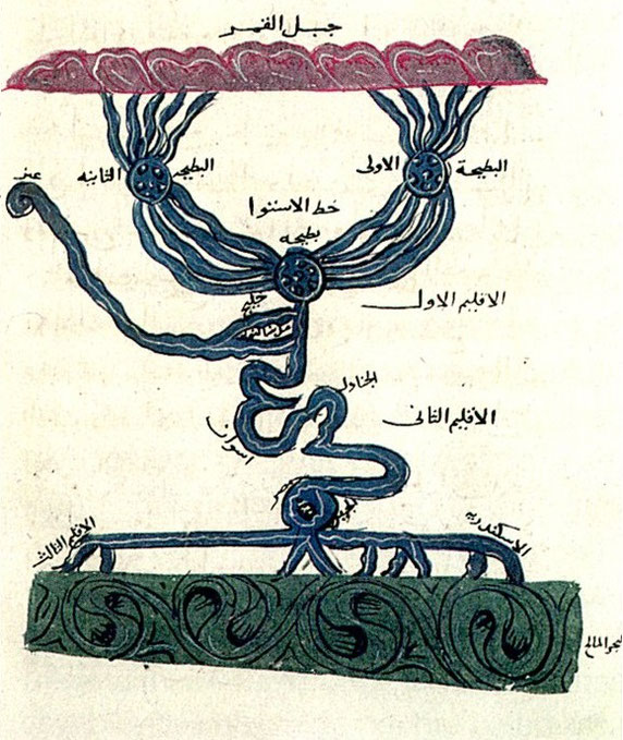
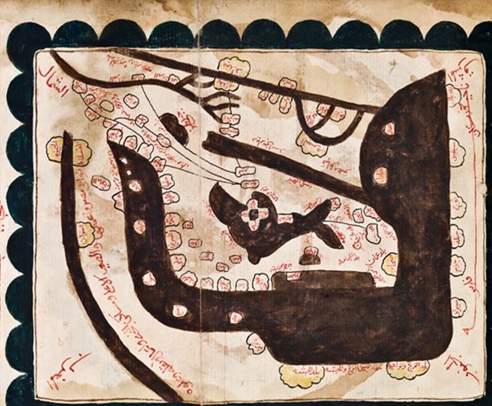
1 Origin of the Persian Sea
2 Land of the Zendjs
3 Desert that separates the Zendjs
4 The land of Abyssinie
5 Desert and waste of the Budja
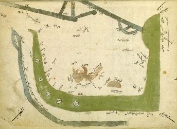
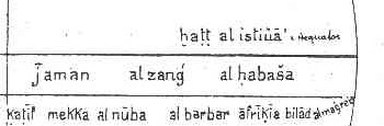
1 The region and the districts of the Zendjs, the desert that separates the Zendjs of the Abyssine
2 the land of Abyssinie
3 Berbera

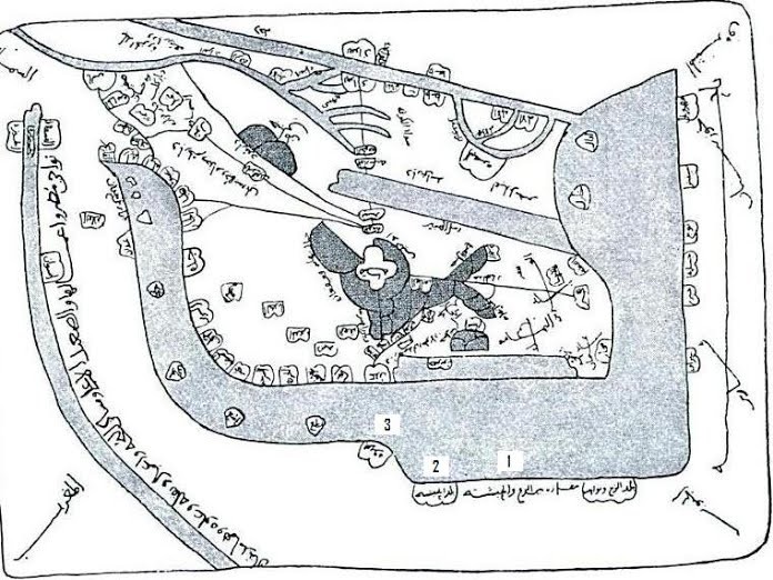
1 The land of Abyssinie /the desert that separates the Zendjs of the Abyssine/ the land of the Zendjs
2 Berbera
3 Zaila
4 Nile
5 The mountain of Qumr
6 The island of QANBALA


Left a climate map with under the translation.