
A map of the seven climes by Suhrab.
Back to Table of
Contents2
To next page
Suhrab (945)
Kitab aja’ib al’aqalim us-sab’a
(Book over the marvels of the seven climes) Baghdad
------------------------------------------------------
This book is edited from a unique MS. In the British Museum. Nothing is known of Suhrab, who is the compiler, but the book was written between AD 902 and 945. The book consist of lists of latitudes and longitudes of towns, of points on the coast lines of oceans, of islands, lakes, mountains, and rivers, etc. Surab, working in Baghdad, proposed a rectangular grid for use in making a world map. This book gives the coordinates for 492 localities, mostly taken from al Khwarazmi. In his work East Africa and the Nile sources are geographically located. No information about the people is given.
Taken from: Youssouf KamalIIIfasc1
M.A. Tolmacheva: Ptolemy’s East Africa
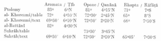
In his table: Qanama: 73deg30min 3deg45min N
In his text: Qanama: 72deg30min 2deg20min N
THE SEAS
(The sea of) Al Qoulzoum (1), of Sind (2), Hind, As-Sin (China), and Fars (3), which is the big sea of the South.
……….Then it continues passing by the city of Madinat at Tib (4), touching the base of the city of Kanana (5) at longitude 72 deg 30' and latitude 2 deg 20' ….. Reaching the city of Rafata (6) at
longitude 65 deg 05' and latitude -7 deg 30' and then to longitude 68 deg and latitude - 13 deg. The latitudes we refer to are beyond the equator, and if it recrosses (the equator) we shall
mention. Now goes the coastline to longitude 72 deg and latitude 14 deg and up to longitude 112 deg and latitude 14 deg………..
THE MOUNTAINS
Mountain of al-Qamar
First limit: 46deg 30min longitude; latitude 11deg 30 min. Second limit, longitude 61deg 50min; latitude 11deg 30min. color: red. Direction of the summit: south.
THE RIVERS
Description of the Nile of Misr and his ramifications. The Nile of Misr originates from the Djabal al Qamar, from this mountain come ten rivers who throw themselves in two lakes situated south of
the equator. Two round seas, the diameter of each is 5 deg. The centre of the first is at longitude 50 deg 5min and latitude -7 deg, 5 min the centre of the second at longitude 57 deg 5 min and
latitude -7 deg. 5 min. Into the first run 5 rivers from the mountains of al-Kumr. The start of the first river is at longitude 48 deg 5 min. and the second one at longitude 49 deg 5 min, the
third at longitude 50 deg, 5 min. the forth at longitude 51 deg 5 min. and the fifth at longitude 52 deg. 5 min. Just the same we have 5 rivers coming out of al-Kumr into the second lake. The
first river starts at longitude 55 deg 20' , the second longitude 56 deg 20' the third longitude 57 deg 30' the forth longitude 58 deg 20' and the fifth longitude 59 deg 10' . Out of each of
those two lakes run four rivers towards a third round lake, which is situated in the first clime. The diameter of this third lake is 2 deg. and its center is at longitude 53 deg 30' and latitude
2 deg. The start of the first river, which comes out of the first sea is at longitude 48 deg 40' the second one at 49 deg 30' and the third at longitude 51 deg 15' . The second and third stream
are united longitude 42 deg and latitude - 1 deg, from here they continue as a sole river. The start of the first river is at longitude 52 deg . The first river which out of the second lake also
in the small third one flows, starts at longitude 55 deg 30', the second at longitude 56 deg 20' and the third at longitude 58 deg. The second and the third come together at longitude 56 deg. and
latitude -1deg 40' and run after this in the named sea as a united stream. The forth river starts at longitude 59 deg. Each of these rivers runs into the third small lake, without that their
mouth is close to the mouth of any of the other rivers. Out of this last lake comes a single very big stream, and that is the Nil of Egypt and he goes only through the Sudan and Alwa (7) and
Zagawa (8) and Fazzan (9) and Nubien and runs past Dongola, the capital of Nubia at longitude 52 deg 20' and latitude 2 deg of the first clime....
(1) (The sea of) Al Qoulzoum: The Red Sea.
(2) Sind: now in Pakistan.
(4) Madinat at Tib: this is his translation of Ptolemy's Aromata emporium.
(5) Kanana: it is his translation of Ptolemy's Panoun Komei
(6) Rafata: Rhapta see Claudius Ptolemy (d165); Periplus Maris Erythraei (AD 100)
(7) land of Alwa: northeast of the merging of the White Nile and the Bleu Nile; was a medieval kingdom in what is now central and southern Sudan. Found in Al Khwarizmi (847); Suhrab (945); Ibn al-Fakih al Hamadhani (903); al-Zayyat (1058); Idrisi (1150); Wasif Shah (1209); Ibn Said (1250); Al-Dimashqi (1325); Ibn al-Dawadari (1335); Ibn Abd’essalam al-Menoufi (15th).
(8)Zaghawa: also called Beri or Zakhawa, are a Sahelian Muslim ethnic group primarily residing in Fezzan North-eastern Chad, and western Sudan, including Darfur.
(9) Fazzan: in south west Libya.