Back to Table of Contents
4 To next page
Idris projected on Modern Map
---------------------------------

Note: to measure the distances I do not use the 100 miles a day(24hours) sailing as given in Géographie d'Edrisi traduction Jaubert but 8 zam(24hours) sailing a day at 20km for a zam as is more generally accepted. Sailing along the coast is only during daylight :12 hours or 4 zam being 80km. With the definition of Jaubert it would be 50 nautical miles (1852m=1NM): 92.6km.
Carfouna: Guardafui (according to Jaubert). Qarfuwa; (from Al Idris ; Ouns al Moubhadj (1192)); the Carfouna or Karmua from Idrisi (1150); Ibn Said (1250): Serfouna or Carfouna (or Qarquna/Farfuna). However: Charles Guillain: The mountain: Djabal-Yerd’foun is resembling Carfouna if you look at the ways it is written in the different manuscripts: Carcouna and Serfouna and Yerd’foun. He proposes Carfouna and Khafouni = Yerd’foun and Hhafoun. Or: although Guardafui and Ras Hafun are different places (but close to each other) (a variation of) the same word is used.

Termeh (Bargal): Ras Terma is also known as Ras Beilul, Ras Darma, Eritrea. Here there is confusion as it is situated towards the Red Sea from Carfouna while all other places that are mentioned after are further south the African coast. See Charles Guillain p 192. However: Ibn Said (1250) and Abulfida (1331) and Idrisi in Ouns al Moubhadj (1192) writes Berma or Barma (Charles Guillain p 238) (Marcel Devic p 57). That place is maybe the Bargal village between Guardafui and Ras Hafun.


The mountain of Khakoui,(Ras Hafun) who has seven peaks.

Khakoui to Markah by sea three small days (240km) and seven over land (7*25=175).
At about that distance you enter a large gulf in which at the entry point has a seasonal river in which many water holes are found. Two more seasonal rivers end in this gulf but with less watering holes. The end of the gulf is the landmark called by Maokun Hei-er. This 40km wide gulf is dotted with settlements and waterholes. Ships coming from the north would not have encountered any better place since reaching Africa. And further south it is even worse.

Two days from Markah in the desert is a river that floods just like the Nile and on which one sows dourah (sorghum): This must be days on foot into the desert and their there are several seasonal rivers ending in the desert leaving green patches but one at the village of Godobjiraan has the fields.


A day and a half by sea (80km*1.5=140km) and four by land (25km*4=100km).
Those 140km brings you to the next gulf which has also a number of waterholes. The end of the gulf is the landmark called by Maokun 剌思那呵 : La si na he.
My choice for Ras Naha is: Bur Gol hill of Ras Cabad which is the only other big promontory further south and the only landmark in a big area, it sticks 2 km out in the sea and has a hill Bur Gol sticking up on the south of it. Since the nineteenth century provided with a beacon for the ships. It is at 6°20’N. Except of it being the only landmark on the route it also agrees with the drawing given by Maokun: First the beachhead followed by the bigger hill in which the name is written. And Al Nadja of Idrissi might be the gulf with the waterpoints preceding it.

El-Nedja to Carnuna eight days. (Most probably on foot 25km*8=200km).
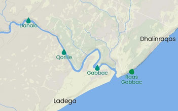
This brings us to south of Hobyo a modern town but an ancient port city. Hobyo was founded as a coastal outpost by the Ajuran Empire during the 13th century (which is too late). The more likely site for Carnuna is El Hur 40km south of Hobyo. Towards El-Hur as well as to several places inland from it many cattle tracks congregate. Inland from it are also many seasonal rivers that fail to reach the sea making the area greener than around Hobyo.
Carnuna to Bazuna six days on foot. (25km*6=150km).
The only place that is at that distance is Mareeg. Now very small. It is not visible how it can have been ever a sizable village. But it is the ocean outlet of the El Dher district. The El-Dher town is located 17 km NW inland at a place where several seasonal rivers pass. Seven km further NW inland starts a huge area where endless enclosed fields are visible.This area (with endless enclosed pastures and fields) starts 70km inland from Hobyo; is 55km wide at Mareeg and ends in the irrigated zone of the Shabelle river south of Mogadishu. And there is also another seasonal seasonal river between El-Dher and Mareeg.

Note: The itinerary does not continue after Mareeg, so we started from some well-known places further south and went back identifying places towards the north. Here we just continue south using the places we in that way identified. Obviously, we do not have any connection with Mareeg.
Bedouna to Medounat three days (80km*3=240km). This brings us from Mogadishu at 200km or Warsheikh at 260km distance to Barawa (=Medounat). The few authors identifying the complete itinerary of Idrisi choose Mogadishu (=Bedouna). Other authors have different identifications; see under.
When using here the definition of Jaubert (that is 50 miles a day instead of 80km) it would be 278km instead of 240km that would bring us to 20km north of Warsheikh.
-The first mention of the town of Mogadsihu is from: Umar Ibn Ali Ibn Samura in 1190. So, it is possible it already existed in 1150 when Idrisi wrote.
-In Barawa or Brava Inscription in the Friday Mosque:
Hajj Shanid ibn Abu Bakr ibn Umar ibn Utman ibn Hasan ibn 'Ali ibn Abu Bakr; and he passed into that (?) tomb in the year 498 being the month of rabi al-ahir. The month of rabi al - ahir of 498 AH corresponds to the period: 21 December 1104 - 18 January 1105 AD. Cerulli however doubted the reading by his informant.

Taken from: Swahili origins: Swahili culture and the Shungwaya phenomenon; Allen, James de Vere 1993
……. a place called 'Baduna', 'Barua' or 'Maruwa' which is usually identified as Barawa.
Taken from: Documents sur l'histoire, la géographie et le commerce de l'Afrique orientale, Volume 1 By Charles Guillain. 1856.
“From Merouat on the coast to Medounat, we count three days.” (Manuscript nr 334 has Beroua and Nebouba; Manuscript B Berouat and Bedouna).
Bedouna, located three days beyond Braoua, could have been located around the mouth of the Djoub, a river from which several Arab geographers, who have indicated it under the title of branch of the Nile, seem to us to have started the country of the Zendj: it would thus have found itself, as Edrisi says, bordering on the latter country.
Taken from: The Arab Geographers and the East African Coast by J. Spencer Trimingham. P127
Bedouna (is Barawa?): Brawa is a harbour is south Somalia. On his map Idrisi began Ard az-Zanj with Baduna. I (=Trimingham) have suggested that this be distinguished from a nearby pagan town with a similar sounding name (=Barawa), and that it may be the later Maqdishu which changed its name with the revival under the Banu Majid shortly after 1159. (= on the arrival of the Banu Majid see my webpage Ibn-al Mujawir(1232)).
Taken from: Shanga: The Archaeology of a Muslim Trading Community on the Coast of East Africa; Mark Chatwin Horton, Helen W. Brown, Nina Mudida 1996
Al Idrisi: BDNA or MDNA (Baduna/Maduna?) at the beginning of the Ard az-Zanj, and thus at the beginning of the Swahili trading system. This could be Manda, but is more likely related to the ethnic name Baduys (possibly equated with the Bajun , the Swahili inhabitants of this area of the coast ) which was recorded by the sixteenth - century Portuguese historian de Barros a ( Freeman - Grenville 1962b , 84 )

Medounat to Mulanda 3 nights and 3 days (by boat). (160km*3= 480km) This brings us from Barawa to Manda.
When using here the definition of Jaubert it would be 555km that would bring us from Barawa to Malindi or Mambrui. But there is still no archaeological prove that Malindi was an international harbor at that time; while Manda did exist.
Mulanda (Manda) two days (by boat) to Manfisa (Mombasa): (160km*2= 320) the real distance is 260km, but as Manda harbor is not at all at the ocean side of Manda island; and Mombasa harbor not on the ocean site of Mombasa island; some hours will be lost.

Mafisa to El'Banas (around Tanga) on foot, six days, and by sea one and a half days. (On foot:25*6=150km; ship: 80*1.5=120km). This must be around Tanga. The site has not been discovered yet but several late medieval unexplored sites are laying around Tanga. The find of coins from Roman emperors and early Islamic coins nearby Tanga are proof a very old harbor was somewhere nearby.

El-Banas to Tohnet (Al-Tuhnat)(=Kaole) by sea, one and a half days, and overland eight days.
(Ship: 80km*1.5=120; foot 25km*8=200km)
KAOLE is a national historic site located in Bagamoyo District in Tanzania. The site is located three miles east of the historic city of Bagamoyo on the Indian Ocean coast.
Archaeological research shows it already existed in the days of Idrisi (1150).
MPIJI (c. 27km south of Kaole and on the shore)
About 27 pieces of Sassanian Islamic sherds (900 to 1100), most of them in the form of bead-grinders and highly brittle, one sherd of white-glazed, Chinese porcelain and 152 pieces of early glass were recovered. Most of the glass fragments were of greenish and yellowish tints, with the surface decaying into a golden patina. Four glass and 215 shell beads were also recovered. Two more grains of Arabic gum were recovered.
Here there is a big gap in the itinerary of Idrisi. Between Dar es Salaam and Mozambique island there are no places mentioned on the mainland. And the places on the islands in this section shows that he had clear knowledge of them.
Where did the ships go after reaching Kaole? Maybe simply turning around. As Mafia, Zanzibar and Pemba are not mentioned they might have kept to the coast of the mainland.
The islands mentioned: are three of the Comoros.
Andjuba (Anjouan-Johanna)
Jazirat min az Zanj, with Jabal an-Nar (Volcano) (Grande Comore)
Kermedet: Mayotte
What we can conclude of this is that from the Mozambique coast the ships did not go north to Arabia but went into (or coming out of) the Indian Ocean to India or the Persian Gulf.
We pick the coast of Africa up again in Mozambique. To know from which place to start we had to work our way back from the south where the exact location of the places is better known through archaeology.


Sayuna to Dandama by sea, to the west, three days, and by land about 20 days (80km*3=240km) (20*25=500km)
Sayuna might be modern-day Quelimane. Dandama might be Angoche island. Both are medieval settlements but no prove is found Quelimane dates from the time of Idrisi (1150).

Bukha to Djantama (should be Jabasta) by sea one day, four days overland. (80km*1=80km)
Bukta is close to the site of Old Mambone in the delta of the Save river. It is a medieval settlement but no prove is found it dates from the time of Idrisi (1150). Jabasta might be on the Bazaruto islands or the mainland opposite the islands and there is archaeological prove that the settlements already existed in the time of Idrisi (1150). At the latitude of Jabasta Ibn Majid (1470) has the names of 5 settlements (can be the same settlements under a different name) so together with the very important archaeological sites there this area has proven to be so important that Idrisi also needs to have knowledge of it. It was also the end station from the shipping route that came around the south of Madagascar. The proof of the existence of this shipping route is found in the archaeology of the Southern coast of Madagascar. It was also the end of the southern trading route out of the big empires in SE Africa.

Jabasta to Daghuta by sea three days and nights (160km*3=480km) should be (80km*3=240km)
Jabasta in the Gulf of Inhambane. Ibn Majid (1470) has two places in the Gulf of Inhambane Manarah or Qanbara or Kandali in the south of it and Malabati in the north of it.
Idrisi (1150) mentions: This land touches on that of the Quac-Quac, where there are two miserable, dirty towns. This is because of the scarceness of food and scarceness of all other things to. One is called Derou (or Zaoura, this last name comes close to the river Zavora, in that neighborhood) and the other Nebhena or Iana'ana (what comes close to modern Inhambane). (In one of the two manuscripts the translator used Nebhena was used in the other Iana’ana). And Zavora is about 80km down the coast from Cape Correntes.
Lereno Barradas also argues that the name of the place must have been Daghuta, the last place of Sofala. He might be right as the placename is very old.
- Ibn Sida (d1066): Daghawa, A race of Sudan, behind the Zinj on an island in the sea.
Also, maybe the same place as Dgo or Dgaop;
-Al-Khalil ibn Ahmad al-Farahidi (d791); Dgo or Dgaop: race of Sudan behind Zinj on the island of the sea.
-Al-Sahib ibn Abbad (995): Dgaop, race of the Sudan behind Zinj.
Taken from: Taken from: THE CAMBRIDGE HISTORY OF AFRICA General Editors: J. D. FAGE and ROLAND OLIVER Vol. 3.
(According to Idrisi) The last town of the Sofala country, Daghuta (=Danghuta?-possibly to be identified with Angoche), and its territory, was that in which most gold was found. (Note that the authors did not investigate the complete text of Idrisi so as to pinpoint the settlement correctly. And Angoche only became a center of gold trade in the 15th century.)
Modern Map taken from Mappae Arabicae by Miller Konrad.

Modern Map taken from : J. Spencer Trimingham (The Arab Geographers) in East Africa and the Orient 1973.
