
---------------------------------------
Left; The worldmap of Abulfeda
Isma’il b. Ali b. Mahmud b. Muhammad b. Umar b. Shahanshah b. Ayyub b. Shadi b. Marwan, known as Aba al-Fida or Abulfeda (1273 – 1331), was a Kurdish geographer, historian, Ayyubid prince and local governor of Hama. He was born in Damascus. In 1312 he became prince with the title Malik us-Salhn, and in 1320 received the hereditary rank of sultan. Taqwim al-Buldan (A Sketch of the Countries) is, like much of the history, founded on the works of his predecessors. A long introduction is followed by twenty-eight tabular forma about the chief towns of the world. His Concise History of Humanity: Tarikh al-Mukhtasar fi Akhbar al-Bashar, was written between 1315 and 1329. His work is important for the knowledge of East Africa in the 14th century.

Text is mostly taken from: - Freeman-Grenville; Selected
Documents,
- Marcel Devic ; le pays des Zendjs
-N. Levtzion and J.F.P.Hopkins; Corpus of early Arabic Sources for West African History.
-Reinaud : Geographie d'
Aboulfeda
First part: PREFACE
As is the case for the countries of the Sudanese. Those countries are many and there are different races e.g.: Habesch, Zendj, Nouba, Takrour (1), Zeyla (2) etc but I only received scant information about them.
Only in very few countries you have the shadow to the south at noon. This happens in that part of Zendj and Habesch that is furthest away, a part that does not passes the third degree latitude.
The equator, starts from the sea of China, goes through the sea of India to the land of Zendj and of the western Negroes and arrives at the encircling sea on its western side.
The big sea, in the south of the inhabited world, is in contact with the eastern sea, and has several names, according to the lands on its shore or the islands in it. The southern sea starts in China and passes by India towards the land of the Zendjs.....
…. In the west the land of Habesh and the cape Berbera. One can also mention the Gulf of Berbera. Each of those Gulfs receives the name of sea because they are big.
The furthest part that people visit who navigate this big sea, on the western side is Sofala of the Zendjs. The sailors never pass that point. The reason being that in the south east the sea throws itself on the coast, and cuts into it at several places and the islands are numerous. As opposite, on the south western side as compensation it is the continent that stretches into the ocean. This place is inhabited by the western Negroes. It stretches from behind the equator till the mountains of Qomr, where the Nile has its sources. From there on the sea has to run between mountains and valleys that go up and down; the water is constantly on the move because of the endless flux and reflux of the sea. When the waves meet each other the boats are put to pieces. That is why they hardly navigate it. That does not stop the southern sea to communicate with the ocean, through these narrow spaces and through the space there is behind the mountains on the southern side. This connection with the ocean has been proven, although nobody has been able to see it with his own eyes. (this whole long paragraph Aboulfeda copied from Biruni in his Qanoun.)(38)
….. the Magreb and the lands of the Sudan. Then the sea goes to the south along uninhabited places to the south of the equator. Then she turns east behind the mountain of Comr where the Egyptian Nile has its springs and she moves along the southern part of the world.
Then (the sea) turns to the east, along uninhabited lands, behind the country of the Zendj. There she gets a north-east direction and goes till the sea of China….

This and all following pictures do not belong to the work of Abulfeda; they are added as illustration only.
Here we a have a map of Mombasa from 1550
Channel of Berbery (3)
The channel Berbery (3) (Alkhalydj Alberbery) is an arm of the sea that detaches from the Indian Sea, to the south of the Mountain Mandeb (4) and the land of Habesch, and which stretches to
the west, up to the town of Berbera, in the land of the Zendj, under 68 deg longitude and 6 deg and a half, or, according to the author of the Canoun (5) at 12 deg latitude. The length of
this sea, from east to west is about 500 miles. Extraordinary things are said on the subject of the waves of this sea. Scherif Edrisi (6) says that the waves go up like high mountains without
breaking. He adds that it is through this sea that one goes to the island of Qanbalu (7), the island occupied by the Zendjs, and where there are Muslims.
We start with the two lakes Albathyhatan (8) at the south of the equator from where the Nile of Egypt leaves. The one that is west is under the 50 deg longitude and 7 deg latitude south. It receives 5 rivers that run down from the mountain of Comr and who will give birth to the Nile of Egypt as we will see later if God wishes. The eastern lake also situated south of the equator has its center under the 57deg longitude and 7 latitude. So it is placed East of the first. It also receives 5 rivers descending from the mountain of Comr as we will explain if God wishes is the article on the Nile of Egypt.
Lake Koura (9)
Ibn Said says that it is a lake on the Equator from which, on the north, issues the Nile of Egypt, on the east the Nil of Maqdishu (10), and on the west the Nil of Ghana (67). The range of
mountains called Jabal al-Muqassim (or Almacsam)(66) (the divider) curves round its south-eastern side from under which the Nile of Maqdishu (10) issues. The rivers coming from the two lakes
above mentioned flow into it. As for al-Sharif al-Idrisi (6), his account is the same as that of Ibn Said as far as the issuing of the Ghana Nil from lake Kura (9) is concerned, but then he
says that Ptolemy denies this and asserts that only the Nile of Egypt issues from it, and that the source of the Ghana Nil (67) is beneath a mountain range there. The author of the Rasm
al-ma'mur ( or Resm-Almamour) (11) says that this lake (Lake Kura)(9) is a circular batiha (8) standing on the Equator with a diameter of two juz (degree) and its center in longitude 53.5 deg
and latitude 0 deg (or according to another version 2 deg N), which would make the longitude of its western side 52.5 deg and its eastern side 54.5 deg.

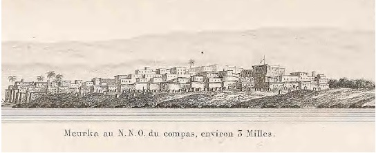
Two drawings from Guillain 1845 on top Mombasa and under Merka.
(or Jabal al-Qamar). There is a difference of opinion concerning the vocalization of the above mentioned Jabal al-Qamar (or djebel Alcomr). Some assign it to the qamar 'moon' which is in the sky and write the qaf and min with fatha (13) but I have seen it vocalized in the book of Yaqut (68) which he named Al-Mushtarik wad'an al-mukhtalif suq'an 'Places which share in the spelling but differ in locality' with damma of the qaf and sukun of the mim (13). He also mentions the island of the Zanj which is in the remotest south and states that its name is Jazirat al Qumr (12), with damma of the qaf and sukun of the mim (13); I have also seen it in the book of Ibn Said al Maghribi with damma of the qaf and sukun of the mim (13). It is also mentioned by Ibn al-Mutarrif in the Tartib (14). He does not mark the vowels (15) but says: It is derived from snow blindness (qamar) of the sight. It is a range in the southern wilderness (kharab). Its latitude is 11 south of the Equator. From it are the sources of the Nile of Egypt from ten torrents which descent from it. It is not certain whether anyone has reached it but it has been seen from afar. Al-Nasir al Tusi (16) says in the Tadhkira that they saw it from afar. It is white from the snow which is upon it. In my opinion this is far fetched for the latitude of 11 deg south is in extreme heat. It is the equivalent of 11 deg north, which is the latitude of Aden in the Yemen, and the falling of snow in a latitude like that of Aden has never been heard of at any time. The southern side is like the northern, but even hotter, because of the sun's being overhead. It says in the Kitab rasm al-ard (or Rems-Alardh) (17): The western end of the Jabal al Qamar aforementioned is in longitude 46.5 deg and in latitude 11.5 deg south of the equator. On this basis its length from its western end to its eastern end is about 15 deg approximately. The Rasm al-ard (17) continues: Its color is red and its highest point is towards the south (wa-ra'suhu ila jihat al-janub) This report differs from that of al-Nasir ( or Nassyr-eddin) that it is white.
First part: FIRST CHAPTER: ARABIA
Sohar: (19)
…………
We read in book called Azyzy (18)(note: 10th century) that Oman is a pretty city, with a port filled with the ships of Sind, India, China and Zendj country. The capital was formerly Sohar (19); there was no more beautiful city on the Persian gulf. The territory of Oman has an area of about three hundred parasanges (20). The country is occupied by the tribe of Azd. (21)

On Top one of the few remains of the past in Mombasa:
Mbaraki pillar Mombassa; (used in spirit worship)
This might well be the oldest surviving monument in Mombassa. Pot sherds have been found in its neighborhood dating back to 1700 and it is found on a Portuguese map of 1710. This means that it
must have been in use as a centre of spirit worship since then and till now. As it is clearly a minaret it must have had an older role which we can not guess when it started

People from Mogadishu in 1931.


A plan of the city of Merka by Guillain in 1845. There is no chance that the town really had the rigid lay out of streets as shown in the drawing.
Under: Malindi
At the Jumaa or Friday Mosque in Malindi is a pillar tomb build in the fifteenth century that honors Sheikh Abdul Hassan, A shorter pillar tomb is thought to have been built in the nineteenth
century.

On top; one of the few remains of the past in Malindi:
In the courtyard of the Juma'a Mosque (Malindi) you can see the remainings of the old mosque: some scattered old stones and parts of walls, a few simple graves and a pillar grave. This one is
really beautiful - and ornated with some fine examples of stone carvings. It's really a lot more interesting than the mosque itself. However it's not quite allowed to walk up to the ruins (the
grassy patch is a Muslim cemetery), so you'll have to take your photos from the distance.
There is an inscription on the small tomb of Sheikh Hassan bin Bakr inside the
Pillar Tomb at Malindi, which has been read: Ya Allah Ya Mohammed Ya Ali.
This is usually a Shia formulary.
This last text is from Studies in African History, Anthropology, and Ethnology James S. Kirkman 1963.
First part: CHAPTER 5 Bilad Al- Sudan.
The purport of Ibn Said's remarks is that if we begin at the western end of the land of the Sudan the first thing we find is some of the towns belonging to the Sudan who are naked and unheeded, like animals. He mentions some of their towns, the names of which are non-Arabic and of uncertain pronunciation viz. the town of Manaqlu (22) in longitude 10 deg latitude 4 deg, then Zafu (23), in longitude 13 deg, latitude 10 deg, zghth (23), in longitude 24 deg latitude 7 deg; brsnh (24), in longitude 29 deg, latitude 7 deg, Kusha (25) situated on springs which feed the last river of the second of the Nile lakes, where the longitude is 53 deg and the latitude 2 deg. Beneath it runs the Maqdishu Nil (10) issuing north of the equator. The territory of Qamar lies between the two lakes. The territory of the Akraw and the Qamar mountains, according to what is related after Ptolemy, are in longitude 51 deg 50' , latitude 11 deg. Around these mountains are the settlements of the Qamar after whom they are named and who (says Ibn Said) are related to the Chinese. The notorious fact about them and about most of those who inhabit that land is that they eat any people who fall into their hands.
The river of Macdaschou (10) goes up to 66 deg longitude and 11 deg latitude; then it descends on the eastern side of the town of Berbera. There remains between the river and Berbera about one deg. of distance after that the river enters into the sea, east of Macdaschou. He who goes further to the east, (starting from the second lake of the Nile) reaches the city of Karfuna (26) in the country of Berbera, still further east the city Berma (27), still further east Hafuni (26), well known to travelers, inside the continent it stretches for about 100 miles, also into the sea it stretches for 140 miles, in northern direction but also east, with clearly visible, its 7 tops.
Malindi is a town of the land of the Zanj, 81.5 degrees long, 2 degrees 50 minutes
lat.. West of the town is a great gulf into which flows a river (is the Sabaki) which comes down from the source many hundreds of miles away in the mountains of Comr (Djebel el-Qomr) (meaning the
mountains of the moon). On the banks of this gulf are very large dwellings belonging to the Zanj; the houses of the people of Comr are on the south side. East of Malindi is al-Kerany, the name of
a mountain very famous among travelers. this mountain runs out into the sea
for a distance of about hundred miles in a north-east direction. At the same time it extends along the continent in a straight line north for a distance of about fifty miles. Among other things
which we might say about this mountain are the iron mine which is on the continental side and the magnetic half in the part which is in the sea. (28)
At Malindi is the tree of Zendj (the ginger tree) (or at Malindi there are many Zanjian sorcerers). The king of the Zanj lives in Malindi. Between Mombasa and Malindi is about one degree.
Mombasa is on the coast. On the west is a gulf along which buildings stand, boats go up river as far as 300 miles. Nearby to the east is the desert (mefasa) which separates the land of the Zanj from Sofala.
Among the towns of the country of Sofala is Batyna (or Banyna) (Note this is most probable the Touhna from Idrissi, distorted by a wrong interpretation of the expression : tousamma bi-Touhna; meaning: it is named Touhna). It is situated at the end of a great gulf, away from the equinoctial line, under 2.5 degrees lat., 87 degrees long. According to Ibn Said, on the west of Batyna is Adjued (29), the name of a mountain which projects into the sea towards the north-east for a distance of 100 miles. The waves of the sea make a great noise here. The people of Sofala live to the east of this mountain: their capital is Seruna (Seyouna)(30), under 99 degrees long. 2.5 lat. (south). The town is built on a large estuary where a river, which rises in the mountain of Comr, flows out. There the king of Sofala resides.
Then one arrives at the town of Leirana (31). Ibn Fathuma (32), who visited the town, said that it was a seaport where ships put in and whence they set out. The people are Muslims. Leirana (31) is on long. 102 degrees, lat. 0 degrees 30 minutes (south). It is on a great gulf. The town of Daghuta (33) is the last one of the country of Sofala and the furthest of the inhabited part of the continent towards the south. It is on long. 109 degrees, lat.12 degrees, south of the equator.[...] the Hasa [are] an abhorrent type of Abyssinians (madmumun min agnas al-Habasa). They have become infamous for castrating whoever falls into their hands. They give away the penises of humans by way of dowry (yadfacun dukur al-adamiyyin fi sadaqatihim), and they boast of such things among themselves. To the east of their land towards the (Red) sea is [the region of] Samhar.
…………
According to Ibn Said is the extend of the Indian sea from the coast of Mandeb (4) till the one of Berbera is eight days sailing.
………..
TABLES
1 The capital of Takrour (1)…..
2 Berysa……(34)
3 Ghana……(35)
4 Koukou….(36)
5 Djadje…..(37)
6 Sofala,
According to the canon (38) it is on 50 degrees 3 minutes long. 2 degrees lat, south of the equator. Sofala is in the land of the Zanj. According to the author of the canon, the inhabitants are Muslims. Ibn Said said that their chief means of existence are mining gold and iron, and that they dress in leopard skins. According to Masudi, horses do not reproduce in the land of the Zanj, so that the warriors go on foot or fight from the back of oxen. I have remarked that Sofala is also a place in India.
7 Matan;
Ibn Said 51 deg., 13 deg. Thus we find in Ibn Said's book.
Ibn Said says; it is level with the angle of the lake called Kuri (39). South of it is Jimi (40), the capital of Kanim (41), and it (Matan itself) is reckoned among the cities of Kanem (41). This is the lake from which the Nile of Egypt, Maqdishu (10), and Ghana (67) issue. It is 1,000 miles long. Its eastern end is in longitude 51 deg. its width at the head is 9.5deg, then it gets gradually narrower until its width at the middle is 450 miles and at the tail 360 miles....
8 Djymy (40)
9 Zeghaoua (42)
...The Zeghaouans are in the land of the Zendjs on the southern side of the first clime... (in the bend of the Nile).
10 Dendema: (43)
According to Ibn Said is the town of Demdems at 54 deg 20' by 9.5 deg. According to Ibn-Sayd, Dendema (43) is the country of the Demdems who invaded Nubie and Abyssinie in 617 AH (1220 AD) at the same time as the Tartars invaded Persia. From there it can be said that the Demdem are the Tartars of the Sudan. In its neighbourhood is the country of Caldjour (69), from where the swords caldjourys come. One finds indeed in those places an iron mine. The longitude of Caldjour (69) is fifty degrees and some minutes, and latitude is two degrees and a half.
11 Saharta (70) ……
The country of the Karla (44) extends from the equator in the neighborhood of the Zendjs of Abyssinia up to south of the mountains Moures………… South of the Karla,(44) the lake of Alhaveres (45) called after a tribe from between the Zendjs of Abyszsinia who live on its shores. Those Zendjs walk naked and live a life of savages
12 Bedje: (46)
According to Athoual (47) at 55 deg longitude and 2 deg latitude. It is outside the first climate, in the south, in the land of Berebra (52). Do not confuse it with the town in the land of the Bedja (64), where there is a gold mine of which we already talked.
13 Djarmy......(48)
14 Vefat……(49)
15 Hadye….(50)
16 Dungola (51)
…....is the capital of Nubia in the first clime; in the south west are the Zendjs of Nubie....
17 Carfoune: (26)
According to Ibn-Sayd, 64.5 deg longitude, 0.20 latitude.
It is situated outside the first climate. In the land of the Zendjs. According to Ibn-Sayd, the town is situated in a gulf , in the beginning of the arc of that gulf. That author adds that it is the first town of the land of Berbera, on the shores of the sea of India. To the east is another town of the land of Berbera, called Berma (27) (or Terma) at 70 deg longitude, one deg latitude.
18 Zeyla (2)….
19 Berebera:(52)
According to the Canon, 55 deg longitude 2 deg latitude. According to Ibn-Sayd, 68 deg longitude, 6.5 deg latitude.
Berbera is the capital of a country that carries the same name, outside the first climate, in the south. According to Ibn-Sayd, Berbera is the principal place of the land of the Barabras (Barabar). Most of the inhabitants have embraced Islam, it is because of that that one does not find any more slaves of this race in the Muslim countries.
I found another translation of this part of the text:
The land of Berbera (52) belongs to the Zendjs but is ruled by the Habacha, who have put commercial ports there. Since the 13th century the town of Berbera is completely Muslim; that is why Ibn Said says this place offers so few slaves to the Muslim places.
20 Marka: (53)
According to the Athoual, 73 deg 8' longitude; but after Ibn-Sayd, 69.5 deg longitude, and 1.1 deg latitude.
Marka (53) is outside the first climate, to the south, in the land of Berebra (52). Ibn-Sayd says it this way: In the east of Khafouni (Ras Hafoun) (26) on the sea shore is the town of Merka, (53) an important harbor. Its people are Muslims. It is the capital of the Haouiya (54) , who own more than fifty villages. It is situated on the side of a river which comes out of the Nile of Maqdechou and which reaches the sea at two days walk from there towards the east. That river makes a bend towards Merka. To the east of Merka (53) is the town of Islam, famous in these areas called Maqdechou.

21 Macdaschou
According to Ibn-Sayd, 72 deg longitude and 2 deg latitude.
Macdaschou depends of both the land of the Zendjs and Abyssinie, it is outside the first climate on the southern side. Mogadoxo is at the shore of the Indian Ocean, its people are Muslims. There is a big river there that because of its floods in summer resembles the Nile of Egypt. They even say it is a branch of the Nile coming from lake Koura (9), passes by in the east and goes on to end into the Indian ocean. Ibn al-Madj (or Ibn-Almadjd)(55) from Mosul calls Maqdechou a big (kebira) town of the Zendj and the Habacha.
Second Part: CHAPTER FIVE: FARS (56)
Siraf (57)
........ houses are built in this country in teak wood and another kind of wood which is imported from the land of the Zindj......
Second Part: CHAPTER NINE: HIND
Sofalah of India
........this Sofala is the one from India; there is another one in the land of the Zindj........
Second Part: CHAPTER ELEVEN: ISLANDS IN THE EASTERN SEA
One of the islands in the sea of Zanguebar is the island of Qomr (Madagascar). One reads in the Moschtarik (58) Qomr is an island situated in the sea in the middle of the lands of Zanguebar and Qumr (here Madagascar) is the biggest island in that sea.
Table of the islands in the Eastern Sea.
The island of Qonbolah (59)
According to the Qanoun (38); 52 deg longitude and 3 deg latitude. To the south of the first climate. In the channel of Berberi (3). (al-Khalij al Barbari.)
One reads in the Atwal of Faras (47): Qonbolah (59) is the capital of the king of the Zindj. Ibn Sa'id says that between this island and Faqati (60)(or Baqati) there is 2.5 deg and that the south coast of the island of Qonbolah on the same line is as Faqati; Qonbolah, he adds, is about two deg. long and as width. Formerly prosperous, it is now in ruins.
Aboulfeda also speaks about the revolt of the Zendj in Irak.
The army of Ali ben Mohammed (Lord of the Zendj) was way bigger. He had found the
most important parts among the Zendjs from Iraq-Arabi and mostly from Sibakh. (61)
Note:
Abulfeda writes : At Melinda is found the plant of Zing.
Meaning the ginger tree. The ginger tree however is from India. The official name for the ginger tree is Zinziber what gave many people to think that it grew in Zanzibar. Marino Sanudo's map of the world (1320) gives a rubric connecting Zinziber with Zinj.
This map of Abulfeda I made by using the coordinates he gives in his text. One can recognize the same East African coast line as Marino Sanudo's map.

|
----------------------------------------------------------------------------------------------------------------------- |
|
|
Aboulfeda: Tarikhu al-Mukhtasar fi Akhbar al-Bashar (The Concise History of Humanity or Chronicles) Taken from : Abulfedae Historia anteislamica, arabice By Abu al-Fida Ismail ibn Ali
The Black People who are the posterity of Ham……. The blacks have different religions; some are magians (fire worshippers) others worship snakes; there are also those who worship idols. It is said according to Galien (62), that the blacks are distinguished by 10 qualities. Kinky hair, small beard, broad noses, thick lips, sharp teeth, malodorous skin, black color, small hands and feet, elongated penises and excessive merriment. Among the important black people are the Abyssins, their country is situated opposite Hedjaz (62); it is the red sea that separates the two countries. This country is long and wide. It is situated to the south east of Nubia. The Abyssinians are those who for a long time occupied Yemen, before Islam. The eunuchs of Abyssinian origin are the most searched of all.................. Among the other black people are: 1The Nubians……….. 2 The Bedja (64); with black colour who go naked and worship idols. Towards traders they show good qualities faithfulness and kindness. This region is gold-bearing and above Abyssinia and beyond the Nile stretching South. 3 The Damadim (43) who live on the Nile above the Zanj, and are the Tartars (at-Tatar) of the Blacks (Sudan). They (the Damadim) waged war against them (the Zanj ?) and killed many, as it happened between the Tartars and the Moslems. They do not care about their religion (adyan); they have idols (awthan) and different manners. In their countries there are giraffes. In the land of the Damadim (43) the Nile divides, one branch flowing towards Egypt, the other to the Zanj. 4 The Zendjs; who are the Negroes of the deepest black. They fight mounted on bulls, they worship idols. They are strongly build and used to harsh live. The splitting up of the Nile takes place above their country close to the mountain of djebel Almicsam (the split). 5 The Takrour (1)…. 6 The Kanems….(41) |
Taken from: islamicbook.ws المختصر في أخبار البشر
(about the year 750-751AD)
……, the ruler of the butcher, his brother Yahya bin Muhammad bin Ali bin Abdullah bin Abbas al-Mosul, (65) and its people had brought out the governor who was there, so Yahya went to Mosul, and when he settled there, he killed about eleven thousand men, then ordered the killing of their women and boys, and with Yahya is a leader with four thousand Zunuy (=pl of zanj) , so a woman from Mosul stopped Yahya and said: It is okay for Arab women to marry Zunuy. So he did her words in it, and gathered the Zunuy and killed them, to the last of them.
(1) Takrour: Takrur: at the border between Senegal and Mauretania. Already mentioned by al Bakri in 1068.
(2) Zeyla: Zeila: in N Somalia close to Djibouti.
(3) channel Berbery; the Barbar Sea: Sea between Somalia and Yemen.
(4) Mountain Mandeb: Bab al-Mandeb: is a strait between Yemen on the Arabian Peninsula, and Djibouti and Eritrea in the Horn of Africa.
(5) the author of the Canoun: see my webpage; Al Biruni; Al-Qanum al Mas'udi (1030) (Picture of the world).
(6) Scherif Edrisi: see my webpage: Idrisi (1150).
(7) Qanbalu; Qanbuluh: The island of Qanbalu from where the Zanj slaves were imported till the great Zanj revolt in Basra. (Zanzibar or Pemba)
(8) two lakes Albathyhatan: Batiha, bataih: batihah or swamps-lakes.
(9) Lake Koura; Kura: Ibn Said mixes up the third lake at the sources of the Nile with lake Chad. From which emerge the Nile of Egypt, the Nile of Magdasu and the Nile of Gana (according to Ibn Said).
(10) Nil of Maqdishu: Nile of Mogadishu: This is the Shabelle River begins in the highlands of Ethiopia, and then flows southeast into Somalia towards Mogadishu. Near Mogadishu, it turns sharply southwest, where it follows the coast. Below Mogadishu, the river becomes seasonal.
Al Zuhri : (1137) Makes the people divert themselves the Nile into a branch to the sea of Yemen; In Dimashqi (1325) it is called the river of Damadim; and he is the only one who kind of understands the river-system in South-Somalia. Salamanca translator (1420): calls it yellow Nile. Ibn Khaldun (1406) says it has nothing to do with the Nile. Nile of Mogadishu appears in Ibn Said al Maghribi (1250); Cowar el-aqalim (1347); Abulfida (1331); al Maqrizi (1441)he calls it River of the Damadim ; Hafiz I Abru (1420); Qoutb al-Din al-Chirazi (1311); Al Qalqashandi (d1418); Qadi Ibn Sasri Al-Shafi’I (1300). Some authors call it: Nile of the Demadem: Cowar el-aqalim (1347) also found in Al-Dimashqi (1325); al Maqrizi (1441): the Nile River Damadem.
(11) author of the Rasm al-ma'mur ( or Resm-Almamour)/ Abulfida refers to the Rasm al-rub al-ma'mur (Drawing of the Inhabited Quarter) as a book attributed to Ptolemy and put into Arabic for Ma’mun.
(12) Jazirat al Qumr: here most probably the Comores; many times however Madagascar.
(13) Fatha is the A vowel in Arabic; qaf is the letter: K; mim is the letter M. Damma is the vowel u in Arabic. Sukun: is a circle-shaped diacritic placed above a letter that indicates that the consonant to which it is attached is not followed by a vowel.
(14) Ibn al-Mutarrif in the Tartib: As for Ibn-Motharraf, it is probably the same as Aboul-vezyr-Omar, who served important functions under the Caliph Almansor and his successors, and died towards the end of the end of the 8th century CE. The author of the Ketab-Alfihrist mentions him. The author does not name the work entitled Altartyb; but he quotes a writing by Ibn-Motharraf relating to Arabia and the various Arab tribes.
(15) He does not mark the vowels: in Arabic most times the vowels are not written.
(16) Al-Nasir al Tusi says in the Tadhkira: see my webpage Nasir Al Din Al Tousi (1274).
(17) Kitab rasm al-ard: Might be Al Kindi (866): Kitab fi rasm al - ma'mur min al Ard. Book of the drawing of the inhabited world. (not extand).
(18) book called Azyzy: see my webpage: Al Hasan ibn Ahmad Azizi Almhellba : al Masalik wal Mamalik (Book of Roads and Kingdoms Azizi)(d990).
(19) Sohar: In Oman close to the border with Dubai.
(20) parasanges: 1 parasangs or farsakhs = 2.8 nautical miles/ about 5km.
(21) tribe of Azd: are an Arabian tribe. They inhabited Ma'rib , the capital city of the Sabaean Kingdom in modern-day Yemen.
(21) Manaqlu: Mancalou; Ibn Said writes Mabalou.
(22) Zafu ; Zefou; Ibn Said has Zafun.
(23) Zghth: M. Reinaud translates it as Zegta.
(24) Brsnh: M. Reinaud translates it as Bersena.
(25) Kus; Qus; Caus : mentioned as being south of Egypt (Ancient kingdom of Kush); A different Qus is a town in the central part of Egypt on the Nile. Repeated by: al-Zayyat (1058); Al Zuhri : (1137); Nuwayri (1333); Ibn al-Dawadari (1335); Salamanca translator (1420).
The same as: Kusha: found in Ibn Said (1250); Abulfida (1331); Al Qalqashandi (d1418) Kouscha: connected to the country of the Kushites who are often mentioned in the hieroglyphs of the pharaohs.
(26) city of Karfuna; Carfoune: Ibn Said has Hafouni: Ras Djafary or Cape Hafun; a promontory in the northeastern Bari region of Somalia. (Ras Hafun) who has seven peaks: the seven peaks on the mountain on the peninsula of Hafun still have different names (Charles Guillain p203).
Charles Guillain: The mountain: Djabal-Yerd’foun is resembling Carfouna (of Idrisi (1150) if you look at the ways it is written in the different manuscripts: Carcouna and Serfouna and Yerd’foun. He proposes Carfouna and Khafouni = Yerd’foun and Hhafoun. (Ibn Said 1250: Hafouny) (Masudi 916: Jafonni or Djafouna) (Abulfida 1331: Khafouni); (Qadi Ibn Sasri Al-Shafi’I 1300: Kerkouna).
(27) city Berma: Idris has Terma; Termeh: Ras Terma is also known as Ras Beilul, Ras Darma, Eritrea. Here there is confusion as it is situated towards the Red Sea from Carfouna while all other places that are mentioned after are further south the African coast. See Charles Guillain p 192. Ibn Said (1250) and Abulfida (1331) writes Berma or Barma (Charles Guillain p 238) (Marcel Devic p 57)
(28) East of Malindi is al-Kerany, the name of a mountain; magnetic half in the part which is in the sea.
Idrisi (1150) has mountain Adjoud which attracts ships: Marcel Devic p 76 prefers Adjarrad because that means in arab: screaming (because of the waves hitting the mountain). Other authors who have a magnetic mountain:
Ibn Said (1250) Alkerany mountain magnetic.
Nasir Al Din Al Tousi (1274) Kvhast (mountain) magnet in the sea of Zanzibar.
Alf layla wa layla (15th cent) the Magnet Mountain (where the Ruc bird lives).
Abulfida (1331) al-Kerany (magnetic mountain).
Some authors conclude from this: Nasir Al Din Al Tousi (1274): Therefore ships here are stitched with cord no nails in the ship.
(29) west of Batyna is Adjued, the name of a mountain: Adjoud: Marcel Devic p 76 prefers Adjarrad because that means in Arab: screaming (because of the waves hitting the mountain); Idrisi (1150): Banas, mountain Adjoud are the same as Ibn Said (1250): Banyna, mountain Ajrad; Abulfida (1331): west of Batyna is Adjued.
(30) Seruna (Seyouna): Sayuna; also found in Al Idrisi (1150); Al Himyari (1461); Ibn Said al Maghribi (1250); Abulfida (1331). According to Marcel Devic p 84 it might be the modern Sena on the Zambezi river.
(31) Leirana; Lirana: Ibn Said (1250): Leyrana; Abulfeda (1331) says wrongly that Ibn Said places it in the land of Sofala.
According to Gill Shepherd (The Making of the Swahili: A View From the Southern End; Paideuma, 1982) Lirana is ‘al-Iharana’ also known as Vohemar, harbour in Northern Madagascar.
(32) Ibn Fathuma: Ibn Fatima: Arab traveller (Sahara, Sudan and East Africa) and navigator added the coordinates of the places, his work is lost. He copied the extracts from Ibn Said (1250).
(33) Daghuta; (east africa): found in Ibn Sida (1066); Idrisi (1150); Ibn Said (1250); Ibn Manzur (1290); Qadi Ibn Sasri Al-Shafi’I (1300); Al-Dimashqi (1325); Abulfida (1331); Al Himyari (1461) has Daghwata. Here it has two rivers, is situated besides the land of the Zanj close to Qumr, at the end of the mountain-chain Ousthiqoun; a town also called Dahna which according to Ptolemy is south of the equator (says Al-Dimashqi (1325)). Mayby the same place as: Dgo: Dgaop; found in: Al-Khalil ibn Ahmad al-Farahidi (d791); al-Sahib ibn Abbad (995). In idrisi (1150) Daghuta it is the furthest south town in the land of Sofala. Sofala was one of the earliest places to be visited by Muslim traders for its gold; together with Qanbalu (Pemba) for its slaves.
(34) Berysa……town dependency of Takrur in the first clime.
(35) Ghana……On the Nile of the Sudan, independent Muslim country.
(36) Koukou….is independent and to the south of the equator and pagan.
(37) Djadje…..formerly independent country but taken over by the Sultan of Kanem.
(38) the canon (Qanoun): see my webpage; Al Biruni; Al-Qanum al Mas'udi (1030) (Picture of the world)
(39) lake called Kuri: lake Koura; Kura: Ibn Said mixes up the third lake at the sources of the Nile with lake Chad. From which emerge the Nile of Egypt, the Nile of Magdasu and the Nile of Gana (according to Ibn Said).
(40) Jimi: (Gimi), (Himi): Suyuti (1505) :island of Chemi: al Makrizi (1441) mentions it on the Niger; Abulfida (1331) and Ibn Said (1250) make it the kaptial of Kanim/Kanem. Al Umari (1349) has Jimi, Jamie, Chemi.
(41) Kanim: Kanem in West Africa.
(42) Zeghaoua: Muslims, part of Kanem
(43) Dendema or Demdems: According to Ibn Said (1250) these are the once who invaded Nubia and Abyssunie around 1220 AD (when the Mongols invaded Persia)
Dendemes, Dendemeh; Dandama: East African people living in the interior, close to the sources of the Nile; also mentioned by Al Masudi (916); Al Idrisi (1150); Ibn Said (1250); Ibn al Jawzi (1257); Harrani (1300); Qadi Ibn Sasri Al-Shafi’I (1300); Al-Dimashqi (1325); Abulfida (1331); Nuwayri (1333); Cowar el-aqalim (1347); Said Abd al Aziz al Dairini (d1385); Ibn Khaldun (1406); Al Qalqashandi (d1418) and Ibn al Wardi (1456) speaks about Demadam; al Himyari (1461).
(44) country of the Karla: they are Ethiopians, the most beautiful among the Africans, Christians except on the coast, those
became Muslims. Also found with Ibn Said (1250): land of the Kazla.
(45) lake of Alhaveres: according to M. Reinaud this lake has to be Tsana or Sana in the Dembea province of Ethiopia.
(46) Bedje: al-Nuga: the el-Nedja of Idrisi (1150) The Bedje of Abulfida 1331 (according to Marcel Devic p66.) Yakut 1220: Nujah (or Nudschah).
(47) Athoual or Atwal: a lost medieval geographical table from Persia called Kitab al Atwal wa’l-rud li-l-furs. With furs meaning Fars; Persia. (The Book of Longitudes and latitudes of the Persians.
(48) Djarmy......Capital of Ethiopia.
(49) Vefat……province in Ethiopia.
(50) Hadye….main town of Vefat
(51) Dungola: Old Dongola is a deserted town in what is now Northern State, Sudan.
(52) Berebera: Barbarah: Here the Berbera in North Somalia or the Berbera coast North of Mogadishu.
(53) Marka: Present-day Merca is a harbour on the coast of south Somalia. To the south of Mogadishu here (as well as Al Idrisi and Ibn Said) placed to the north; identification unsure.
(54) Haouiya: El Hadye: Hawiya: In south Somalia mentioned by Ibn Said (1250); Ahmad ibn Al Harrani (1300); Al Idris Ouns al Moubhadj (1192); Idrisi (1150) has El Hadye; Abulfida (1331); Haouiya; Dimashqi (1325) Hawiah; Al Wardi (1456) Haouina.
The reference in Al-Idrisi (1150) to the Hadiye and in Ibn Sa’id (1250) to the Hawiye, on both occasions associated with the Benadir port of Merca, where the Hawiya live today, suggests that they have been in this area for at least 700 years. The references slightly later in the Futuh al-Habasha to Somali groups in north-western Somaliland indicates that the population in this area has also remained substantially unchanged since the sixteenth century, when the work was written. The Galla another group from the Horn has been living there at least since the 15th century as Fra Mauro (1459) mentions a Galla River in Ethiopia.
(55) Ibn al-Madj: also found in Maqrizi (1441).
(56) FARS: region in Iran.
(57) Siraf: Siraf was the harbour of Shiraz province of Persia; and the place of big trade with East Africa.
(58) Moschtarik: The book of Yakut (or Jakut) al Hamawi (1220) also called Kitab Mu'jam al-buldan
(59) Qonbolah; Qanbalah: Qanbuluh: The island of Qanbalu from where the Zanj slaves were imported till the great Zanj revolt in Basra. (Zanzibar or Pemba)
Atwal of Faras: Athoual or Atwal: a lost medieval geographical table from Persia called Kitab al Atwal wa’l-rud li-l-furs. With furs meaning Fars; Persia. (The Book of Longitudes and latitudes of the Persians)
(60) Faqati (or Baqati): Ibn Said (1250) puts it in Ethiopia.
(61) Sibakh: Coastal evaporite desserts.
(62) Galien: Galen: Aelius Galenus or Claudius Galenus (129 – c. 216 CE), was a Greek physician, surgeon and philosopher in the Roman Empire.
Galen: In the black ten qualities not found or not present in the other: this statement is repeated endless: Al-Mas'udi (916), Abu Ubayd Al Bakri (1067), At Tahqiq fi sira ar raqiq (1250); Ibn al Jawzi (1257); Al-Qazwini(d. 1283); Al-Dimashqi (1325), Abulfida (1331), Al Amsati al Hanafi (1478).
(63) Hedjaz; Hedjah: Hedjaz or Hijaz: the province of Mecca.
(64) Bedja; Bedjah, Bedjneh, Beeljah : Beja people from Sudan. The Egyptians leaving from Aswan; the southern border town on the Nile; have to cross their territory to reach the harbours on the Red Sea.
(65) Yahya bin Muhammad bin Ali bin Abdullah bin Abbas al-Mosul: the Abbasid governor of Mosul in 751.
(66) Jabal Makhasam: The mountain Muqasam El-Moquecem; Muqassim: literally symmetrically divided, close to the source of the Nile; also found in Ibn Al Wardi (1348); Hafiz I Abru (1420); Ibn Said al Maghribi (1250); Al Idris ; Ouns al Moubhadj (1192), al Harrani (1300); Abu al-Fida (1331).
(67) the Niger river.
(68) see my webpage Yaqut (1220)
(69) Dimashqi has the Qaldjours, Kaldjur among the people on the Niger river; Abulfida has among the Dendema: Caldjour; Idris has among the Ethiopians Caldjoun.
(70) Sahartat; Sahartah; Sahart: also mentioned by Abulfida (1331) and Dimashqi (1325); Makrizi (1441) as a major part of Ethiopia.