Back to Table of Contents 6
To next page
Al-Dimashqi (1325) Nukhbat ad-dahr (Wonders of the world)
from Damascus
-------------------------------
Shams al-din Abu Abd Allah Muhammad ibn Abi Talib al Ansari al Dimashqi (1256AD-1327), having lived all his live in Syria. His work Nukhbat al dahr fi aja’ib al barr wal bahr; the Choice of the Age, on the Marvels of Land and Sea, shows no great originality, and in fact it is largely identical in its contents (though it differs in the order of presentation) with Manahij al Fikar by al Watwat (d1318). As to East Africa; he gives a detailed geographical situating and mentions the minerals, the Nile, Mogadishu, Qumr, Daghuta (9), Anfoudja (20), Qanbalu. I was still unable to search all the volumes of the book.
Taken from : the translation by M.A.F. Mehren 1874 /
Also called Dimichqi
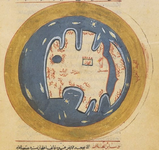
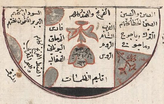
Left and under worldmaps found in the ms. For the round map Zanj الزنج is found close to the top of the near-island on the right side of the continent. For the map under it is found in the middle part of the top island. The translation of this entire map is given at the bottom of the page.
CHAPTER 1 CONFIGURATION OF THE EARTH
P9
The equator starts at the fortune and eternal islands (2) in the western sea or green
sea and goes east, to the north of the mountains of the moon (djabel al-Kamar) and the region called Sofala, of the land of the Zendjs and the isles in that area, passing the island Dybadjat (3)
between the Isle Sarandyb (4) and the isle Seryra (5)....
P11
On the other side of the equator there were in the days of Ptolemy eight towns: Al-Komar, Aghna (49)(Ceylon), Lokmerana (6), Dahna (7), Lenlemeh (8) (west africa), Daghuta(east africa)(9),
Sefakis (10), Kegha (11)....
P12
Part of the big isle of Komr, as well as the islands of Wakwak (12) and Kasmyn, stretch to the south, extend in the sea, as well as part of Daghuta (9), situated in the land of the Zendjs, on the
shores of the pacific sea, close to Komor isle. Access to it is possible. It is possible to speak to its people. Those of Komar isle, the isle of Lohmerana and Dahna (7) are of the pure color,
long hair and easy mind compared with the Negroes of Kaldjur (13) and Kuku (14)....
P13
The equatorial region is inhabited by communities of Blacks who are to be numbered among the savages and beasts. Their complexions and hair are burnt and they are physically and morally deviant. Their brains almost boil from the sun’s excessive heat ... The human being who dwells there is a crude fellow, with a very black complexion, burnt hair, unruly, with stinking sweat, and an abnormal constitution, most closely resembling in his moral qualities a savage, or animals. He cannot dwell in the 2nd zone, let alone the 3rd and 4th, just as the people of the 1st zone live not in the 6th, nor those of the 6th in the 1st, or the equatorial region, because of the difference in the quality
of the air and the heat of the sun. God knows best!
P15
First climate......... the northern part of the island of Qomar........ The archipelago of the Zendjs....... the sea of Yemen......... Berberah (52), the island of Soqotra........The northern part of the mountain chain called mountains of the moon, the two lakes from which leaves the river Nil and one more lake, the land of Demadem (15) and Habyssinie (16) are in this first climate.
P20
The third, the chain of Qamar, that means of the Moon, they separate the southern and deserted part of the northern and inhabited part of the earth; in the middle of its extent are the sources of the Nile, the country of Demadem (15) and Ghana.
P22
(about rivers in the first climate). 36 (rivers) you find on the other side of the equator among those 4 are on the island of Qomor (17); they are called Aghbab (19), 10 come out of the mountains of the moon, er-Rahun on the island of Serendib (82), Djob (18), the big and the small one, in the land of Maqdashou, 2 in the land of Daghoutah (21), 3 in the land of Ousthiqoun (22), 3 on the island of Anfoudjeh (20), the river Sefaqis (10), the river Temin, the river d'Alhou (23) on the other side of the mountains of the moon , the river of Loqmeraneh (60) , the river Dahneh and 2 rivers on the island of Serirah (5).
Another division of the Earth according to the opinions of the ancients.
Ardeshir-ibn-Babek (24) divided the Earth into four parts, one belonging to the Turks, the other to the Arabs, the third to the Persians, the fourth to the Negroes. King Feridoun (83) imagined the division of the Earth in the form of a bird (25), which China would be the head, India the right wing, the country of the Khozars (84) and Turks the wing left; the Hejaz (85), Yemen, Iraq, Syria and Egypt the chest, and the west the tail, the feathers extended towards Sudan.
P23
Alexander the Great divided the people of the earth: he called one part Europe,
consisting of ....... another Ifriquia (26) consisting of Egypt, the Arab gulf, Habesh, Zendj, and the southern ocean.
According to the opinion of Said al-Andalousi (86), the Negroes and the Berbers are of the same race to the north of them are situated the Koptes (87) and the Yfrendj (88); the Indians and the
Zendjs, a race to the north of which live the people of Arabia .......
CHAPTER 2 MINERALS
P73
The Bedjadiq is a kind of Bedjadi (the granate stone); there are mines of it in the land of the Zendj, and pieces are found as big as one Rathl (27) of Baghdad.
P73-74
Saili (gravel deposits) is the name of a stone, brought by the water from the mountain of Rahoun at Ceylon and from those of the islands of Saili, situated in the sea of China. It is rare that you find a pure one. According to a traveller who went there to collect stones, there are in the valleys big lakes, owned by the kings of the districts, the kings of India, the Zendj, of Qamroun (89), and the highest dignitaries of their kingdom as well as ponds and logs where there is a lot of water, floods and fashions. It stays in them. These ponds, logs, and holes that are placed on the way of the flood, when the flood flows and flows, it fills them with mud, stones, and other sediments that it brings with it, and when the flood subsides and the flood remains, every nation He comes to his ponds, logs and holes and takes out their mud and other sediments and keeps them somewhere so that the rain, sunlight and air can hit them, and every time there is a flood, they resume the same work until that time. Let the mud and what they have poured on it in the following times dry, and they will take out the ruby, diamond, cat's eye, balkhash, violet and other rubies that they find in it. This is their method when every flood comes, and God knows best.
P82
The emery; stone containing iron, hard, can be used to shape all stones and minerals with the exception of the hyacinth and the pearl, which are shaped with a diamond that can shape all stones. Its color is yellow or black, a little bid mixed with yellow, there are mines in China, India, on the island of Ceylon, and the land of the Zendjs; the best are from Nubia from around Aswan (28). Completely pulverized and bedded in gum, baked in the fire, so as to make it saturated in emerite. This way round cakes are made which all gem stone cutters use for sharpen up their gems.
P87
The oil stone, according to Aristotle (29) is red with bluish light; touched by oil it is changed , the oil penetrating right to the centre. It comes from Sofala of Zandj. When it is rubbed over a garment stained with oil, it removes all traces immediately.
P88
The magnet of men, according to Aristotle (29), is the stone Bahit (30), located at the end of al-Hou (23) river behind the sources of the Nile of Egypt, beyond the Mountains of the Moon. Its color is white, bright as silver, but a more intense whiteness. It is a small rock consisting of a single stone, he who comes close is attracted by a force of love and enchantment, approaching more and more, he attaches to the stone and he does not cease to be gay and happy, until he dies. This is what Ptolemy tells us; travellers and traditions tell us that a company aimed to explore the sources of the Nile, followed the course of the river, until it came to a valley in the mountains of the Moon where there was no way for any human being to pass through because of the ruggedness of the tracks and the density of jungles there. One of them climbed the summit of the mountain which oversaw the watercourse of the river, and when he reached the summit he gave a great shout and threw himself from the top while his companions were looking at him. Another one of them did the same thing, and then they decided to tie a rope to the next to see what was on the other side of the summit. The man did the same, but his companions were mindful of that; and they quickly pulled him up. When the man regained consciousness, he informed his companions about the splendorous view and the glorious sight which he beheld behind this mountain, mentioning that his friends threw themselves because they were charmed by the Nile source's outlook. This exploration group returned home without reaching the main source of the Nile River and without seeing anything more than what that man saw from the top of the mountain.
CHAPTER 3 FOUR RIVERS
P105-107
According to the opinion of scholars, the river of Egypt, called the Nile or river of Nubia, comes out of the mountains of the Moon, which separates the inhabited land south of Equator and beyond to the North of the southern or burned part, of which we have no knowledge; its springs are ten rivers running continually among steep mountains and sandy grounds; the distance that separates the most eastern of these affluent from the most western, is 15 days; all throw themselves into two vast lakes, separated from each other by a distance of four days. The circumference of the eastern lake, with its islands and mountains, is 3 days and that of the western lake is about 5. The countries around these lakes and rivers are populated by wild Negro tribes, whose manners resemble those of ferocious animals; they eat those who fall in their power; when they made a prisoner of a another tribe, they kill it and feed on it like venison.
Those two lakes with their rivers are situated between the 50 deg and 56 deg longitude and between 6 deg and 7 deg latitude on the other side of the equator. The eastern lake is called lake Koukou (90) or Tamin of the Sudan the western one lake Demadem (15)(32), of Qaldjour (13) and Hedjami. From each of these lakes 4 rivers leave, who after having passed through the areas where the Negroes live, unite at 7 latitude in a third lake of considerable size, called Djaus (31) lake, lake of the flowing together or lake Koura of the Sudan, with a circumference of 6 days when following all the bends of its shores, peopled with Negro tribes, of Djaous (31) and Koura. From there three big rivers leave, of which one flows to the west, called river of Ghanah, the other to the east declining to the south called the river of Demadem (15)(32) or of Maqdashou; the third called river of Nubia or Nil, goes to the north to its mouth in the Mediterranean, as the Demadem (15)(32) River flows into the southern sea and the Ghanah River in the Atlantic. According to Qodamah (34), one of the ten rivers already mentioned, namely the most western, is called al-Hou (23), whose waters come from below stones of magnet. The author of the book known as: Delights of one who wants to cross the country (33); says that the Nile is heading from south to north, crossing the desert on a stretch of 4 months, high and low Abyssinia over that of a month and a half, the high Egypt to the Mediterranean, 15 days. The first the place where the Nile disappears is in Nubia; it is invisible for 3 days of journey …….
The length of its course, from its sources to its mouth, is 3,000 parasanges (35) with all its detours and meanders.
P108
El-Khowarezmi (36) says: The sources of the Nile come out of the mountains from the moon ; near the high Nile, in the desert, and on the border of Abyssinia, there is an animal named Hippopotamus; it is black and similar to the buffalo; only its volume is more great; he has a fluctuating neck mane and tail, and hooves like those of the buffalo. Sometimes he is breeding ordinary mares….
P113
Those two rivers pass the city of Baghdad, the Tigris in the east, The Euphrates in the west. Ships coming from China, of Yamamat (37), Hind, of Zendj and other countries, go up river to the town
on the Tigris.
P138-139
The river of the Damadim (32) is a great stream with copious water. It too issues from lake Kuri (or Kourah) and passes through the territory (majalat) of the Damdam of the Sudan and Lamlam (38)
of the Zunuj and Qaljur (13) and Hajami of the Habash (39) being for one month between steep mountains where no profit is made of this water ; then the water goes to the east traversing in ten
days the land of the high Khasse (40), of Ablin, of Akaky and of Kenawer (41) during one and a half month towards the north-east; then it returns to the south through the land of Hawiah (42) up
to the red Makdishu, where it has an arm called Wabi-river, which goes through the lands of Zaila, Badi, Zengbar, and the coast of Berbera, close to the land of Makdashou it splits in three arms,
one of which is the big Gubb, the other one the small Gubb, the third the river of Demdem (43). On the shores of these three rivers live the Zeng tribes, and the Sudan Negroes, and among the
cities there is Sofalat az-Zeng and Kiljata (Kilwa). All three end up in the southern part of the Zeng sea, 2 deg or 3 deg on the other side of the equator.
P154
On the island of Dhoudha (44), close to the coast of Maqdashou, at a distance of one and a half days from the island of Habesh, there is a source which gives birth to a river, of which the water
has the smell of camphor.
P157
After Ibn Hauqal there are behind the land of the Zendjs salt lakes and rivers…..
P161
On the Island of Qomor (17) there are 4 big lakes and 4 fast rivers, called Agbab.
CHAPTER 6 THE SOUTHERN SEA
P197
Towards the south we know the coast of the great Komar island (48). The island is
four months long, but the southern part is uninhabited, like all the land over there. There is only one single entrance to the sea which is in the strait made by the mountains of Ustykun (22), it
is a mountain chain, stretching for 200 miles into the sea, there are high mountains among it and it continues east to where the chain of Komar (48) starts and the land of Daghuta (9) crossing
the middle of the earth where is the dome of Arin (45). It is said that Khidhr (46) entered this chain with d'Ou-l-Qarnein's (47) army. In the strait, between these mountains, there is a vehement
current, produced by the movement of the sea, by the ebb and flow and by the impetuosity of continuously agitated waters from south to north, so that the passage is impossible for any kind of
ship, either large or small; its width is 100 miles, and the flow is so strong that the waters cover the heights up to an elevation of 6 poises (poise=1.95m) and spread on the plains up to a day.
This is repeated 4 times day and night. After this strait the water slows into a sea up to the mountain chain of Komar (48) and Daghuta (9), where is the gulf of Daghuta (9). There the sea forms
two channels, on the east and west side of Komar island and a third one which separates the island of Anfudja (20) and Seryra (5) from Komar (48) island. These three channels end into the Indian
sea, which carries different names.... at the end are the Wakwak (12) islands after the mountain chain of Ustykun (22)
P199
On the land of Komar (48) are 4 big rivers called Aghbab (19), and about 20 towns. The biggest is called Dahna (7), Lokmerana (6) is the place where the king lives, and the capital is called
Aghna (49).
Serirah (5), with a circumference of 1200 miles, contains many cities, of which
Serirah (5) is the most famous; we find there the best kind of camphor.
The island of Anfoudja (20) (Unguja different from the one on Zanzibar) is long and 2000 miles in circumference. It has unused land and deserts. The people live in the northern part on higher
altitudes, where they see the sea on the left and on the right.
P200
The island of Qomar will be mentioned after this.
When the sea has passed the Island of Qomar, she becomes bigger and has several names, and this after the coasts and places she passes; but all those different seas are only one, of which the longest stretch extends from in the west Maqdashou, Sofalah and Berberie of Soudan…
P201
Then the sea reaches the coasts of Dagouta (21), and the ones of the land of
Zandj-ez-Zendj, of Maqdashou the red one and the land of Kalbeh (50), inhabited by Zendj Muslims, having reached its biggest extension along the equator, she takes a direction in a circular form
, sometimes towards the North-west sometimes North-east; here it is called sea of Berberie or Red Sea, because of the dangers the navigators meet there. This sea stretches to the north, up to a
black mountain in the sea which is called Khafouny (51), no ship passes there without the risk of failing. That is why when approaching one does his vows and humbles oneself before the Almighty,
it is only through His grace that one is saved. Then it passes the coasts of Hawya (42), called this way because it resembles hell because of the heat and the intensity of the fire of the sun,
then those of Berberah (52), a part of Demdem (15) and lower Abyssinie, the land of Djebra (54), of Badhi (55), of Zendjebar, Zeila (53), and Outil, where it forms a golf called sea of Qolzoum
(57)……
P204
To the east is the sea of Qomor (17) or Qomar or Loqmeraneh (60).
Towards the south we arrive at the sea of Zendj or of Berberah (52), of which the coasts are called Zendjbar.
The island of Anfoudjah (20), with a circumference of 2200 miles, is not totally inhabited; in its southern part we find deserts and unused lands.
P207
The island of Qomar, according to which el-Qomari wood carries its name has a circumference of one month; it contains many cities, populated by devotees from China and India, and from scientists. A king, named Qameroun, reigns there. There is a big quantity of Buddas and idols like nowhere else; the painters distinguish among the Budda representations, the Buddha merciful, or squinting, or crying, or laughing, or hiding, as we said before in speaking of the race that people the country of Tippera (56). There is a gold mine, ebony and peacocks. The elephant is imported, and the rhinoceros lives there too; we will give the description below.
P208
On the eastern side of Qomar is the royal castle, and a river passing through…..
P210
The island of Malay, to the east of the island of Qomor (17), is populated by pirates
who ply their trade on the sea and have revolted against their king; now they are called Bahariyya. On this island grows the teak tree, which grows tall and strong. By hollowing them out, vessels
are constructed of it, formed of a single plank of wood; the length of this board is forty cubits (91) long and a width of seven. (80)
P215-216
The islands of Diba (Laccadive and the Maldive) are a coherent group, with Arab
people; the biggest island is called Diba or Diab, it is 400 miles in circumference, you find there the banana tree, sugar cane, the coconut tree and the cassier. It is a halting place for the
ships going to Kish (58), Hormuz, India, Yemen. Magadoxo on the Zanguebar and Abyssinie. (1)
The island of Serendib (in Indonesia).....
One finds there the giraffe, an animal with a remarkable shape; it has the neck of a camel, the skin of a leopard and of the deer, the horns of the antelope, the teeth of the cow, the head of the
camel and the back of the coq. The front legs are very long just as the neck; it measures 10 el (59) and more but it has the rear legs very short and without movements. Only the front legs have
knees like with other animals, because the neck is to short in comparison with the front legs when it wants to graze. When walking, it puts the right front foot forwards together with left back,
this is different from other animals, the animal is naturally nice and sociable towards the others, it is a herbivore, and its excrements are like the camel.
p216-217
The island of Qomor (17) or the island of Malai (61), long of 4 months and large of one month, is situated opposite the island of Serendib (82) towards the south, there where this one is towards
the north. It includes several cities, including Loqmeraneh (60), Malai, Dahma, Khafour, Balik, Daglah, Qoumariah are the best known; according to the last, a species of pigeons bears the name
Qoumari. This island is very rich in forests that produce a wood hard and dry, the length of such a tree reaches up to 200 cubits, and the circumference of the root is 120 cubits (91). The
southern coasts, towards the sea of darkness, are covered with deserts and uncultivated land populated by a race of niggers who go naked, only dressed in a kind of leaves, called leaves to write.
These leaves are similar to those of banana, but they are wider, thick, soft, soft and durable; they actually make notebooks to write recipes and expenses, as in an account book. When this island
became too small for its population, houses were built on the shore at the foot of a mountain, which bears the name of these inhabitants, extending in a line contiguous as far as Sudan and the
sources of the Nile. This island contains, in the vicinity of the mountain of Zendj, gold mines and hyacinth. The white and grey elephants live there too, and on the coasts of the ocean, there is
a quantity of horned wild animals, which cannot be tamed because of their impetuosity; there are also beasts with round-figure, as big as that of the human, with thin and long ears, skin striped
red and white, similar to the fabric, called Attabi; they are also wild.
It is also said that the bird Rokh (92) lives there, he flies very high and on the east coast you everywhere find the feathers he lost and they are used to carry water (81), the shaft is very
long, it is black and several inches thick. They are exported to Aden where they are known as feathers of the Rokh. According to the assertion of the travellers who came there, we find eggs of this bird, similar
to a dome. Some reliable sailors say that having approached this island to take water, they found a dome, which they approached; then one of the merchants tells them: it's the egg of the Rokh
(92) bird, after which they pierced it and opened it as a cupola built. After satisfying their hunger and thirst from the contents of this egg, they left it and fled to the ship. Shortly after,
the Rokh arrived and found his broken egg, removed a very large rock and looking for the ship, he flew over their heads, then he threw the stone he was carrying in his claws to the ship. The
sailors, working the oars and helped by the wind, avoided the rock, but the agitated waves nearly overturned the building, and the bird continued his persecutions until night fell saved
them.
P218
About the islands of the sea of the Zendj and the marvels of that sea, also called sea of Berbera or sea of Maqdashou the red one:
According to the geographers, the sea of the Zendj carries this name because it follows the shores of the land of Zendj; it is also called sea of Berbera, because its coasts are inhabited by a
race of Negroes, speaking the Berbera language, of which the pronunciation is very fast, like of a man who is leaving, and Red Sea because of the dangerous waves, the high temperature and the
fire that is visible at night. The land of the Zendj is situated towards the south under Canope (93), and the sea at its shores together with the Pacific, is like this one, covered in darkness.
If ones goes south on this sea you see the two poles, south and north together, going further south the pole star together with the chariot disappears and a heap of unknown stars appear on the
horizon.
Among the islands of this sea, Qambalou (94) is among the islands of the Zendjs; it is densely populated, one can find there ebony, spices and gold mines.
The island of Thaisan, with a big and violent crater, which blows out fire with a terrible noise, so that nobody can live in its neighbourhood, because of the enormous heat that reigns
there.
The island of Berbera is populated by Muslim Negroes, who belong to the Zeidite sect and Shafiite. (62)
The island of Qothroubia (63), circumference of 300 miles, has two villages from the Zendjs, and a very high mountain, where live the Gouls, called Qothroub, because of their ferocity.
The big group of islands of Zendja, situated according to Ptolemy at a longitude of 95 deg and latitude of 2 deg, consists of 700 islands, one close to the other, inhabited by the Zendjs, who
feed on chicken peas and millet. On one of those islands, one dives for very expensive pearls. One day when a ship was there, a merchant who had with him a half bag of chicken peas, offers them
for sale, he sells them at one pearl for each pea, his companions seeing this, sell their stuff at the same price, they make big profits. When they came back a second time, having lots of peas on
board, the people refused to buy them, they had planted what they had bought the first time, This plant grows there very well and is seen all over, it is black from color.
The Burned Island (64) is located towards the South; it is rarely discussed. It is so called, because, every 30 years, a tail star [a comet], appearing on the horizon and climbing to the zenith during the 6-month course, drops fire that burns everything on the island. At its appearance, the inhabitants flee for a time, after which they return.
P220
The island of Djana is well populated and cultivated. There is a species of venomous snakes, whose skins have the property to cure the fever and phthisis, when one rests on carpets, made of these skins. (65) They catch these animals by means of smoke from storax benzoin. Hunters, after piling up a quantity of this material, which is brought to them by merchants, smoke the surrounding caves of these snakes when there is a strong north or south-east wind. The wind, carrying the smoke to the snakes, intoxicates them, after which the hunters continue to kill them, until the smoke has stopped, or the wind be calm. The author Ahmed, the librarian, gives us this relation in his work, entitled al-Mebahidj.
The Isle of the one-eyed (66) is populated with a race of Negroes of small size. At the time of planting comes a bird species, called gornouk, (crane), which devastates everything, and attacking the laborers, tears out their eyes. According to Aristotle's (29) book on animals, cranes come from Rhorasan on the shores of the Nile in Egypt, where they also attack inhabitants; the height of this tribe is one cubit.
P221
The islands of Dibadjat (95), large and small, near each other, are situated in this sea (sea of Yemen). The island of Dibadjat is in the middle of this group; it is the most wonderful of all these islands, because its inhabitants are dark black, and all that is found at home: dust, stones, the animals, up to the sugar cane, are of the same color; the plants are very dark green, so are the millet and the camphor.
CHAPTER 9 ABOUT THE DIFFERENT TRIBES
P384
The historians assert that the cause of the black complexion of the sons of Ham is that he had sexual intercourse with his wife while on the ship and Noah cursed him and prayed to God to modify his seed, so that she brought forth the Sudan. Another version is that Ham came upon Noah asleep with his privy parts uncovered by the wind. He told this to his brothers Sam and Yafath and they rose and covered him, turning their faces backward so that they might not see his shame. When Noah knew of this he said: Cursed is Ham (67), blessed is Sam, and may God multiply the seed of Yafath. But in truth, the fact is that the nature of their country demands that their characteristics should be as they are, contrary to those connected with whiteness, for most of them inhabit the south and west of the earth.
P389
Behind the land of Alwa (68) there is an area, inhabited by Negroes, who are naked like the Zendj, and are very stupid and have no religion….
P390-391
To the tribes of the Negroes belong also the Zendj or the Zaghouah (70), called after Zagou, son of Qofth b. Micr b. Kham; they are divided in two tribes, the Qabliet and the Kendjewiat, the
first name means ants, the second dogs (69). Their capital is Maqdashou, where the merchants of all countries go. It owns the coast called Zenjebar, which has several kingdoms. They are divided
into several tribes, are most of the time naked, and are the most savage of all people. The land (of the Zendjs) is 700 parasangs (71) long and wide, it has rivers and mountains, habitations and
sand plains, it is combined with Daghuta (9) and the coast of the Pacific where is the island of Komar (48) with the dome of Arin (45) in the middle of the equator. The people who live on its
borders are known for their enormous cruelty, they sharpen their teeth so they can eat the human flesh; they have no religion or religious opinion, but only the law ordained by their kings. The
supreme king is called Touqlim (or tuqlim or buqlim) meaning 'son of the Lord' (72) a name that has been conserved by all kings in all ages. Among the northern Zenj are some who have a literary
language in their own tongue (73) so that they compose discourses, inserting tearful homilies which they recite at gatherings on their festivals and commemorations.
About the other Negro tribes, who live on the shores of the sea of India and the one of Sind (74) and Mend (75), they say they are brothers, descendants of Noufir b. Qopt (76) or of Koush b. Kham
(77).
P393
O Commander of the Faithful, there are four things which are not found in four nations: generosity among the Greeks, good faith among the Turks, courage among the Copts, and despondency among the Sudan….
Cheerfulness (tarab) was divided into ten parts; the Sudan got nine parts, the rest of the nations one….
P396
The people of the equator and the surrounding areas; are the Zendj, the Negroes, the Abyssinians, the Nubians, they are all black; this color is caused by the sun which burns terribly hot there. Going up to the zenith twice a year never leaving to be close, producing a terrible heat, which makes their hair already dark, completely black, curled and thick, resembling hair touched by fire. The prove that they are really touched by fire is that they never grow. The skin is not dried up, because all dirt comes out of the body by the heat. Their brain in overcooked and they have little intelligence, their thoughts lack consistency, and their intellectual possibilities are small; you don't find with them opposing qualities like faith and disloyalty, righteousness and trickery. As they cannot combine opposed ideas, they don't have laws, as legislation always has opposites in it, like the commandments and self-defence, desire and abstinence; so no prophet was ever sent to them.
P397
The nature of them resembles the primitive. It is given to them immediately by nature, without being thought. it is that what makes them react like animals without reflecting, and going
immediately into action, like you can see the courage of the Lion, the tricks of the wolf, the cleverness of the fox, the shyness of the rabbit, the obedience of the dog, the force of the horse,
the animals do not possess opposed qualities. Those people obey to their kings and their princes, because they have imposed to them their laws and government, what you also see among the
animals.
The Negro has, according to Galen (78), 10 properties that cannot be found in the whites, to know: frizzy hair, sharp eyebrows, swollen nostrils, thick lips, sharp teeth, stinky skin, bad nature,
hands and feet cracked, long penis and excessive cheerfulness. As for the eunuch, his bones harden, his feet grow, his skin narrows, his legs lengthen, his fingers curl and he is safe from
leprosy; he will preserve all that was proper to him, before the time of his castration, of his moral, physical and constitutional qualities, with the weakness of the voice, the feminine gaits
and the excess of lustful desires.
P398
The second climate is less hot than the first; It has the countries of Sind (74) and Hind and the surrounding peoples, except the Negroes. They are called tanned, the sun has not burned their heads and their hair, neither blackened their skin, but only their color a little less than that of the Negroes; it's this color that is called blackish. They are very alert, but do not like gambling, drinks, or pleasure, because of the warmth of their heart and their drought; they are not legislators, because of the excess of heat. Similarly Zendj are less burned as the Nubians, those being located in the Orient and exposed to the winds of the Indian and Pacific sea, these westward are exposed to the winds of the Negro lands, to the Simoun (79) and Jahmoum; their bodies are burned and blackened and their hair wrinkled. Likewise the Abyssinians, who live in the mountains near fresh waters, are green, brown or black.
Under more worldmaps from his manuscripts


Al-Dimashqi; Kitab al-siyasa fi ‘ilm al-firasa
(Approach to Physiognomy) (1325)
----------------------------------------------------------------------
Taken from: MIGUEL ÁNGEL LUCENA ROMERO: LA SEXUALIDAD ÁRABE E ISLÁMICA MEDIEVAL A TRAVÉS DE LA TRADUCCIÓN DEL KITĀBAL-ĪḌĀḤFĪ ASRĀR AL-NIKĀḤDE AL-ŠAYZARĪ
Byzantine women are the purest in the womb, Andalusians are the most beautiful in appearance, the most penetrating in smell, the most loved, the most praised for their succession and the hottest vaginas. The Turks are the ones with the best intercourse until they are twenty-five, then tenderness is shown in them. Those from Sind (74), from India and the slaves the most unpleasant, the ugliest, the most spiteful, the most mindless, the ones with the worst domestic government, the most smelly and with a dirty uterus. Those belonging to Bilad al-Zanj and Ethiopians are those with the best breath, most tender bodies and the most delicate in spirit and most obedient. Baghdadis and Babylonians are best liked for men's pleasure. The best for coexistence and enjoyment are the Syrians, who are the intermediate women.
(1) The islands of Diba (Laccadive and the Maldive) are a coherent group, with Arab people; the biggest island is called Diba or Diab, it is 400 miles in circumference, you find there the banana tree, sugar cane, the coconut tree and the cassier. It is a halting place for the ships going to Kish, Hormuz, India, Yemen. Magadoxo on the Zanguebar and Abyssinie.: Here with making the island of Diab big and connect it with East Africa; we see the beginning of the error that finally led Fra Mauro to add a big island of Diab in the south east of Africa and put on it the most important East African towns.
(2) the fortune and eternal islands: Canaries
(3) Dybadjat: Al-Dybajat; or Dijabat is the Madives islands.
(4) Sarandyb: Sri Lanca.
(5) Seryra: Serirah, Seryra: According to Mehren probably on Sumatra. Also in Abulfida (1331) Saryre; Reinaud (the translator) says it is in Bengal.
(6) Lokmerana: this according to Al-Dimashqi (1325) is an island where Zanj people live as well as a river with the same name and a town also Lokmerana which according to Ptolemy is south of the equator (says Al-Dimashqi (1325)). And there is also a sea of Lokmerana which is also called sea of Qumr. Also the king lives in Lokmerana this time on the island of Qumr and the most important town on Qumr is Agna (which Idrisi (1150) puts in Serendib.); While the biggest town is Dahna (on p216 in Dimashqi called Dahma); al Maqrizi (1441) has Dahna.
(7) Dahna: this according to Al-Dimashqi (1325) is an island where Zanj people live as well as a river with the name Dahneh and a town also called Dahna which according to Ptolemy is south of the equator (says Al-Dimashqi (1325)). Also according to him Dahna is the biggest town (on p216 called Dahma) on the island of Qumr.
(8) Lenlemeh (west africa) on the niger called Lemlem on p138; a town also called Lenlemeh which according to Ptolemy is south of the equator (says Al-Dimashqi (1325)).
(9) Daghuta(east africa): also found in Idrisi 1150. Also found in Ibn Manzur (1290); Ibn Sida (1066) Qadi Ibn Sasri Al-Shafi’I (1300); Abulfida (1331); Ibn Said (1250); Al-Dimashqi (1325); Al Himyari (1461) has Daghwata. Here it has two rivers, is situated besides the land of the Zanj close to Qumr, at the end of the mountain-chain Ousthiqoun; a town also called Dahna which according to Ptolemy is south of the equator (says Al-Dimashqi (1325)).
(10) Sefakis: on the island of Anfoudjeh there is the river of Sefaki (Sefaqis); there is the sea of Sefakis on the other side of the equator; also a town also called Sefakis which according to Ptolemy is south of the equator (says Al-Dimashqi (1325)).
(11) Kegha: is mentioned between West African places on p15 and p138 and p173 and p342.
(12) islands of Wakwak: on p199 he mentions they are behind China.
(13) the isle of Lohmerana and Dahna are of the pure color, long hair and easy mind compared with the Negroes of Kaldjur: Dimashqi has the Qaldjours among the people on the Niger river; Abulfida has among the Dendema: Caldjour; Idris has among the Ethiopians Caldjoun.
(14) Kuku: people of West Africa also found in al-Zayyat 1058; Ibn al Jawzi 1257; Al-Dimashqi 1325; Ibn Wadih al-Ya'qubi (d897) has Qaqu; Yakut 1220 Koko.
(15) Dendemes, Dendemeh; Dandama: East African people living in the interior, close to the sources of the Nile; also mentioned by Al Masudi (916); Al Idrisi (1150); Ibn Said (1250); Ibn al Jawzi (1257); Harrani (1300); Qadi Ibn Sasri Al-Shafi’I (1300); Al-Dimashqi (1325); Abulfida (1331); Nuwayri (1333); Cowar el-aqalim (1347); Said Abd al Aziz al Dairini (d1385); Ibn Khaldun (1406); Al Qalqashandi (d1418) and Ibn al Wardi (1456) speaks about Demadam; al Himyari (1461).
(16) Habyssinie: Ethiopia
(17) island of Qomor; Madagascar
(18) Djob, the big and the small one, in the land of Maqdashou.
Djoubb (El Jub): a dug, non-masoned waterhole (according to Marcel Devic p70); the name still exists in the name of the river Jubba. Must have been close to present day Kismayo. Is mostly mentioned by Chinese authors: Yakut (1220); Al-Dimashqi (1325); Fei-Hsin (1436) has Giumbo; Xuanzong Shih-lu (1438) has Zhu-bu; Zhang, Tingyu: Ming Shi (1739); Luo Maodeng (1597). Some authors say the channel mentioned by al Masudi (916) is the Jubba: “…Zinj were the only ones who had crossed a tributary of the Nile (the Jubb) which flowed into a bay or canal, which in turn opened into the Indian Ocean…”.
(19) Aghbab: or Gobb: a Gulf or an arm of the sea (the sea penetrating the land).
(20) Anfoudjeh: Idris (1150) has Andjuba, Ibn Said (1250) has Anfoudja. Gill Shepherd (The Making of the Swahili: A View From the Southern End Paideuma, 1982) is sure it one of the Comores (Anjouan-Johanna) and also called Unguja (El Anfoudja); Lunjuya (Unguja) like Zanzibar. According to Marcel Devic; Anggoudja is the Swahili word for ‘wait’, what makes it for him a waiting place for ships. The modern word in Swahili is ‘ngoja’ but the pronunciation remains unchanged. Dimashqi 1325 speaks a lot about Anfoudja; for him it’s a huge nearly deserted island.
(21) Daghoutah: (east africa): found in Ibn Sida (1066); Idrisi (1150); Ibn Said (1250); Ibn Manzur (1290); Qadi Ibn Sasri Al-Shafi’I (1300); Al-Dimashqi (1325); Abulfida (1331); Al Himyari (1461) has Daghwata. Here it has two rivers, is situated besides the land of the Zanj close to Qumr, at the end of the mountain-chain Ousthiqoun; a town also called Dahna which according to Ptolemy is south of the equator (says Al-Dimashqi (1325)). Mayby the same place as: Dgo: Dgaop; found in: Al-Khalil ibn Ahmad al-Farahidi (d791); al-Sahib ibn Abbad (995). In idrisi (1150) Daghuta it is the furthest south town in the land of Sofala. Sofala was one of the earliest places to be visited by Muslim traders for its gold; together with Qanbalu (Pemba) for its slaves.
(22) Ousthiqoun: in the Chinese area.
(23) the river d'Alhou; is also mentioned as al-Hou when talking about the magnet of men. And al-Hou again as one of the ten rivers at the sources of the Nile.
Alhou river: according to Reinaud river Jeou; a river that empties in lake Chad.
(24) Ardashir: Ardeshir-ibn-Babek: Ardashir I (l. c. 180-241 CE, r. 224-240 CE) was the founder of the Persian Sassanian Empire, which lasted from 226 A.C to 652 A.C. He was the son of prince Babak. Mentioned by:
-Japheth ben Ali ha-Levi (10th): Ardashir who reigned from India unto the land of al-Zanj.
-Al-Dimashqi (1325): Ardeshir-ibn-Babek divided the Earth into four parts, one belonging to the Turks, the other to the Arabs, the third to the Persians, the fourth to the Negroes.
- Nuwayri (1333); Dara the elder, son of Ardashir, married the daughter of the king of Zinj.
- Maqrizi (1441): Ardechir ben Tabek says that the Earth consists of four parts, one of which belongs to the Turks, the other to the Arabs, the third to Persia, and the last to the Negroes.
(25) Bird map: the only manuscripts that have such a map see my webpage: Abul Mufakhir: Ashkal al-alam of Jayhani (The Shapes of the World)(1219). Authors that describes a bird map is Al-Muqaddasi (985); Al-Dimashqi (1325).
(26) Ifriquia: Ifriqiya, was the area of eastern Algeria, present-day Tunisia and Tripolitania (today's western Libya).
(27) Rathl; Ratl-weight: standard ratl of 440 grams in Umayyad Egypt.
(28) Aswan: southern border of Egypt.
(29) Aristotle: was a Greek philosopher and polymath during the Classical period in Ancient Greece.
(30) Pieces of the story of the stones Baht or Bahit brought by Alexander from the country of the Zanj and found in the mountains of the moon called the magnet of men or who make people laugh till they die and which story comes originally from Aristotle can be found in: al Maqrizi (1441); Suyuti (1445-d1505); Qadi Ibn Sasri Al-Shafi’I (1300); Al Umari (1349); Al-Dimashqi (1325); Al Zuhri (1137); Salamanca translator (1420).
(31) Djaus (Djaous) and Koura: according to Mehren probably both mean lake Chad. Abulfida makes them two separate lakes.
(32) river of Demadem or of Maqdashou: as lake Demadem is the western lake this is very improbable. The most logical explanation is that in the text the western lake is the eastern and vis versa. Cowar el-aqalim (1347) also speaks pf the Nile of Demadem or of Maqdashou; al Maqrizi (1441): the Nile River Damadem.
Nil of Maqdishu: Nile of Mogadishu: This is the Shabelle River begins in the highlands of Ethiopia, and then flows southeast into Somalia towards Mogadishu. Near Mogadishu, it turns sharply southwest, where it follows the coast. Below Mogadishu, the river becomes seasonal. Al Zuhri : (1137) Makes the people divert themselves the Nile into a branch to the sea of Yemen; In Dimashqi (1325) it is called the river of Damadim; and he is the only one who kind of understands the river-system in South-Somalia. Salamanca translator (1420): calls it yellow Nile. Ibn Khaldun (1406) says it has nothing to do with the Nile. Nile of Mogadishu appears in Ibn Said al Maghribi (1250); Cowar el-aqalim (1347); Abulfida (1331); al Maqrizi (1441)he calls it River of the Damadim ; Hafiz I Abru (1420); Qoutb al-Din al-Chirazi (1311); Al Qalqashandi (d1418); Qadi Ibn Sasri Al-Shafi’I (1300) Cowar el-aqalim (1347).
(33) The author of the book known as: Delights of one who wants to cross the country: Al Idrisi (1150)
(34) Qodamah: see my webpage on Qadama (930)
(35) Parasanges: 1 parasangs or farsakhs = 2.8 nautical miles/ about 5km.
(36) El-Khowarezmi: see my webpage on Al Khwarizmi (847)
(37) Yamamat: the last part of Saudi Arabia, before Iraq starts.
(38) Lamlam of the Zunuj : Lenlemeh (west africa) on the niger called Lemlem on p138; a town also called Lenlemeh which according to Ptolemy is south of the equator (says Al-Dimashqi (1325))
(39) Qaljur and Hajami of the Habash: as these first two places belong to the western lake of the Nile this is very improbable. The most logical explanation is that in the text the western lake is the eastern and vis versa.
(40) high Khasse: Mehren adds that this is a tribe of Ethiopia from close to the Red Sea.
(41) Kenawer: Ethiopia according to the description by Dimashqi (1325) on p342
(42) Hawiah: Hawiya: In south Somalia mentioned by Ibn Said (1250); Ahmad ibn Al Harrani (1300); Al Idris Ouns al Moubhadj (1192); Idrisi (1150) has El Hadye; Abulfida (1331); Haouiya; Dimashqi (1325) Hawiah; Al Wardi (1456) Haouina.
The reference in Al-Idrisi (1150) to the Hadiye and in Ibn Sa’id (1250) to the Hawiye, on both occasions associated with the Benadir port of Merca, where the Hawiya live today, suggests that they have been in this area for at least 700 years. The references slightly later in the Futuh al-Habasha to Somali groups in north-western Somaliland indicates that the population in this area has also remained substantially unchanged since the sixteenth century, when the work was written. The Galla another group from the Horn has been living there at least since the 15th century as Fra Mauro (1459) mentions a Galla River in Ethiopia.

(43) The river of the Damadim ……. through the land of Hawiah up to the red Makdishu, where it has an arm called Wabi-river, which goes through the lands of Zaila, Badi, Zengbar, and the coast of Berbera, close to the land of Makdashou it splits in three arms, one of which is the big Gubb, the other one the small Gubb, the third the river of Demdem..(this description of the river system in South Somalia is the most correct of the ones found in medieval sources. It off course does not extend as far as Kilwa and Sofala.)
(44) island of Dhoudha, close to the coast of Maqdashou,
(45) dome of Arin: derived from qubbat uzain; qubbat al ard: dome of the earth. Mythical island being the belly button of the earth. Found in Al-Dimashqi 1325; Ibn Said al Maghribi (1250); al-Zayyat (d1058); Al Garnati (1169).
(46) Khidhr: is a figure described but not mentioned by name in the Quran as a righteous servant of God possessing great wisdom or mystic knowledge.
(47) d'Ou-l-Qarnein: Dhû-l-Qarnayn, literally "He who has two horns", is a personality mentioned in the Qur'an in Surah 18, Al- Kahf ("the cave"). He build the wall of Gog and. A historical tradition identifies him with Alexander the Great although there is no consensus on this.
(48) Komar island: Madagscar.
(49) Aghna: Idrisi (1150) puts it on Serendib.
(50) Kalbeh: according to Mehren situated in Oman. He does not explain why it is inhabited by Muslim Zanj.
(51) Khafouny; Carfouna: Guardafui (according to Jaubert).
Charles Guillain: The mountain: Djabal-Yerd’foun is resembling Carfouna if you look at the ways it is written in the different manuscripts: Carcouna and Serfouna and Yerd’foun. He proposes Carfouna and Khafouni = Yerd’foun and Hhafoun. (Ibn Said 1250: Hafouny) (Masudi 916: Jafonni or Djafouna) (Abulfida 1331: Khafouni); (Qadi Ibn Sasri Al-Shafi’I 1300: Kerkouna).
(52) Berberah: here the Berbera coast north of Mogadishu.
(53) Zeila: in N Somalia close to Djibouti.
(54) Djebra: (Djabara); Abulfida (1331) and Ibn Said (1250) put it is Abyssinia.
(55) Badhi : Yakut (1220) puts it on the coast of Hijaz (Arabia).
(56) Tippera: he puts this country on the islands in front of the West African coast.
(57) Qolzoum; al-Qulzum: located at the head of the Gulf of Suez.
(58) Kish: Qish: Kish island is located in the Persian Gulf, 19 km from mainland Iran, and has an area of approximately 91 km2. It was very important in early Abbasid times.
(59) El: is a northwestern European unit of measurement, originally understood as a cubit (the combined length of the forearm and extended hand). (45cm).
(60) Loqmeraneh: Lokmerana: this according to Al-Dimashqi (1325) is an island where Zanj people live as well as a river with the same name and a town also Lokmerana which according to Ptolemy is south of the equator (says Al-Dimashqi (1325)). And there is also a sea of Lokmerana which is also called sea of Qumr. Also the king lives in Lokmerana this time on the island of Qumr and the most important town on Qumr is.
(61) The island of Qomor or the island of Malai: On page 210 they are still separate islands. Mehren adds; this island seems to combine Madagascar with parts of Sumatra and Java.
(62) The island of Berbera is populated by Muslim Negroes, who belong to the Zeidite sect and Shafiite: The Zayadite are Shia Muslims and the Shafiite are Sunni.
(63) island of Qothroubia: Idrisi (1150) has an island Cotroba which he situates just north of the island of the monkeys. Inhabited by Arab Christians who are pirates. Ibn Said (1250): Cotria.
(64) Burned Island: Qazwini (1283); Al-Dimashqi (1325); Qadi Ibn Sasri Al-Shafi’I (1300) Mustawfi, Hamd-Allah ibn Abi Bakr Qazvini (1340) also mentions it.
(65) There is a species of venomous snakes, whose skins have the property to cure the fever and phthisis, when one rests on carpets, made of these skins. : this story is found in: Abu Ubayd Al Bakri (1067); Ibn Al Wardi (about 1456); Qadi Ibn Sasri Al-Shafi’I (1300); Wasif Shah (1209); Al-Dimashqi (1325); Qazwini (1283) .
(66) The Isle of the one-eyed: also found with Al Qazwini (1283); Al-Dimashqi (1325); Musa Ud-Damiri (d1405). The story was also known in China: Tu Yu (801): The little people are to the south of great Ch'in (Rome). Their bodies are barely three feet long. At the season of plowing and planting their crops they fear lest they be eaten by the cranes. But great Ch'in provides guards to protect them, and the little people exhaust their treasures to repay and reward them.
(67) The curse of Ham is repeated by:
- Ibn Qutayba (880)
- Ibn Wadih al-Ya'qubi (d897)
- Al-Kisa'i (d904)
- Eutychius of Alexandria: (d. 940 A.D.)
- Muhammad Bal'ami (10th)
- Al Rabghuzi; Qisas al Anbiya (1300)
-Al Dimashqi (1325)
- Ibn Khaldun (1406)
- Suyuti (1505)
(68) land of Alwa: northeast of the merging of the White Nile and the Bleu Nile; was a medieval kingdom in what is now central and southern Sudan. Found in Al Khwarizmi (847); Suhrab (945); Ibn al-Fakih al Hamadhani (903); al-Zayyat (1058); Idrisi (1150); Wasif Shah (1209); Ibn Said (1250); Al-Dimashqi (1325); Ibn al-Dawadari (1335); Ibn Abd’essalam al-Menoufi (15th).
(69) they are divided in two tribes, the Qabliet and the Kendjewiat, the first name means ants, the second
dogs.
The two tribes among the Zanj:
-Sahib Ibn Abbad: (995): A Tale of Al Jahiz in which: Zinj of two kinds, one called lkfw and the other lytw
-Jahiz (869) repeated it in two books: Kitab al Hayawan and Al-Fakhar al-Sudan.
The tribes of Zinj are of two types: the ants and the dogs, this tribe are the dogs, and that tribe are the ants,
-Al-Dimashqi (1325): they are divided in two tribes, the Qabliet and the Kendjewiat, the first name means ants, the second dogs.
-Suyuti (1505): As for Zinj, two classes Kabila and Katajwia.
(70) The Zaghouah are according to Abulfida (1331) located on the Nile, he also counts them among the Zanj. They might be the Zaghawa often mentioned.
(71) Parasangs: 1 parasangs or farsakhs = 2.8 nautical miles/ about 5km.
(72)The supreme king is called Touqlim (or tuqlim or buqlim) meaning 'son of the Lord'
Names of the king of the Zanj with different authors:
Ibn Khordadbeh (868) Alfikhat.
Masudi (916): The king of Zanj is called Flimi.
Al-Khwarizmi: (d997) Almehraj: King Alzabaj and Zinj.
Abu Ubayd Al Bakri (1067): And the Flymy (title of king) has three hundred thousand cavalry.
Al-Raghib al-Isfahani (1109): Al Buhraja: sahib al Zunj.
Al-Qazwini(d. 1283). Atar al Bilad: And they have a King named Aokulaim.
Muhammad al Fasi, Maliki: (d1429-30): Al Hyaj: the king of Zinj and Ghana.
Wasif Shah (1209): Their principal king is called Kunah; he resides on the shore of the sea, in a place called Kandu.
Al-Dimashqi (1325): The supreme king is called Touqlim (or tuqlim or buqlim) meaning 'son of the Lord'
Note:
Charles Guillain: ( Documents sur l'histoire, la géographie et le commerce de l'Afrique…. P173) gives several versions on
how different translators translated the word Flimi (King) of Masudi (916): M. Reinaud: Oklimen; M. Quatremère: Wakliman; M. Sprenger: Afliman; Deguignes: Phalimi and Aphlimi.
(73) literary language in their own tongue, see on this: Al-Jahiz (869); Abu Zaid al Hassan(916); Al Masudi (916); Ibn al-Nadim: (987); Ibn al Jawzi (1200); Wasif Shah (1209); Dimashqi (1325); Nuwayri (1333).
(74) Sind: now in Pakistan.
(75) Mend: also found in Idrisi (1150)(but not on my webpage and Ibn Said (1250); Al-Dimashqi (1325)
(76) Noufir b. Qopt: Ham gave birth to the Copts of Egypt.
(77) Koush b. Kham: Ham; one of the three children of Noa.
(78) Galen: Aelius Galenus or Claudius Galenus (129 – c. 216 CE), was a Greek physician, surgeon and philosopher in the Roman Empire.
Galen: In the black ten qualities not found or not present in the other: this statement is repeated endless: Al-Mas'udi (916), Abu Ubayd Al Bakri (1067), At Tahqiq fi sira ar raqiq (1250); Ibn al Jawzi (1257); Al-Qazwini(d. 1283); Al-Dimashqi (1325), Abulfida (1331), Al Amsati al Hanafi (1478).
(79) Simoun: Simoom is a strong, dry, dust-laden wind in the dessert.
(80) Jean Claude Hebert (Les Zavaga ou Zabaga Indonesiens (=Vazaha), artisans et trafiquants du fer, commerçants ou pirates
( ?) a Madagascar et aux Comores, aux XIIe-XIIIe siecles.) p11 concludes from this paragraph that these people must be the descendants of the Zavaga of Idisi (but the name has changed). They
are now called Bahariyya what in Arab means the People of the Sea, the Malagasi term: Talaotra. According to Herbert Dimashqi is the first one to let us know the existence of the Talaotra (People
of the Sea) at Madagascar who live from maritime commerce or as pirates.
(81) That the tube of the feathers of the Roc bird are big enough to be used as buckets is found in: Buzurg ibn Shahriyar (955); Li Kung-Lin (d1106); Chou Ch'u-fei (1178); Ch'en Yuan-Ching (late12 century); Chao Ju-Kua (1226); Ibn Said al Maghribi (1250); Luo Miandao (fl. ca. 1270); Marco Polo (1295); Al-Dimashqi (1325); Chou Chih-Chung (1366); Ning Xian Wang (1430); Ibn Al Wardi (1456); Alf layla wa Layla (15th); Wang Khi (1609).
(82) in Indonesia.
(83) Feridun: mythical king of Persia who overthrew Zahhak. He has a role in the Ali ibn Ahmad Asadi: Garshasp-name (1066) (History of Garsasp); Abu Tahir Muhammad al-Tarsusi (12th century); Darabnamah-yi Tarsusi (History of Darab by al-Tarsusi).
(84) Khazars: Semi nomadic people from south Russia, south Ukraine, Crimea, Kazakhstan.
(85) Hejaz or Hijaz: the province of Mecca.
(86) see my webpage on Sa'id al-Andalusi: Kitab Tabaqat al-'Umam (1029-1070)
(87) Copts of Egypt.
(88) the Ifrendj: the Francs of Europe.
(89) in Indonesia.
(90) Koukou or Qaqu: the Kuku of West Africa found in al-Zayyat (1058); Ibn al Jawzi (1257); Ibn Wadih al-Ya'qubi (d897) has Qaqu; Yakut 1220 Koko; Suyuti (1505) has Koukou as well as Al-Dimashqi (1325); Abu al-Fida (1331); Abu Ubayd Al Bakri (1067).
(91) cubits: Distance from fingers to elbow (45cm).
(92) the bird called the rokh: the giant bird Roc lived in Madagascar.
(93) Canopus, Canope: is the brightest star in the southern constellation of Carina and the second-brightest star in the night sky. The south celestial pole can be approximately located using Canopus and another bright star, Achernar, as the three make an equilateral triangle.
(94) Qanbuluh: The island of Qanbalu from where the Zanj slaves were imported till the great Zanj revolt in Basra. (Zanzibar or Pemba)
(95) Dibu (Diabwa): Dibadjat; Dvipa=Island: Maldives