

The translation of Africa from the worldmap of his mss.

(Geography of Hafiz I Abru) (1420) Herat
------------------------------------
Abdallah (or Nur-Allah) ibn Lotf-Allah ibn 'Abd-al-Rashid Behdadini known as Hafiz-e Abru (Born in Khorasan and died in 1430) was a Persian historian working at the courts of Timurid rulers of Central Asia. Timur's son Shah Rukh (1405-1447) ordered the historian Hafiz-i Abru to write a continuation of Rashid al-Din's famous history of the world, Jami al-tawarikh. His description of East Africa has few new things to offer.
Taken from: The Miller atlas
Hafiz-i Abru, his real name being Sihab al-Din Abd Allah ibn Lutf-Allah ibn Abd al-Rasid al-Hwafi.
Also called: Ms Chronicle or Tarikh of Hafiz Abru
Taken from: جغرافیای حافظ ابرو http://kakheaseman.ir
A worldmap found in his mss and the translation for Africa.

The Persian Sea (meaning the Indian Ocean)
P93
And the surrounding countries, one India and the other China and Tibet and the other three Turks and Caspians, fourth Rome and Saqqalaba (=Slaves) to Al-Franj, fifth Egypt and Syria and Arab land, sixth Zanj and Abyssinia and the Maghreb to the end of the inhabited part. And the author of the book Masalak al-Mamalak (1), most of which is a translated in this book, says that we divided the earth into two parts. And the delineation of this part starts from the sea of China and passes into the land of India, it than passed through the lands of Islam to the lands of Egypt and the Maghreb. Whatever is on this side of the north are white people, and as far as they go (Whiteness will prevail over them. And that which is in the south is black, and also farther away). Blackness will prevail over them to Abyssinia and Zanzibar, which is the end of the inhabited part from the south.
P99-100
But the south-west, towards the sources of the Nile, to a position where the latitude of the south reaches about sixteen degrees and a fraction, is the high mountain, which is called the mountain of the moon. And it is not possible to cross that mountain. And there are some places are deserts and salt and desert and no one has reached the sea from there and no certain knowledge has been obtained. It is said by conjecture and argument that there must be a sea on the other side; and in this sense, this sea is called the sea of the environment. And it should be known that through such a revelation, there are many other seas. Some connected to the environment and some not connected. And from this sea, which is on the south side of Ma'murah (=Mohit; the all encircling ocean), there are many bays (to) Ma'murah, and the most important of them are four bays: on the west side, the Gulf of Berber is about Berbera, and its length on the north side is one hundred and sixty farsakhs (2) and width. He is forty-five miles in the middle and most of his beaches it is a desert and little development from this barbaric land. After that is the Red Gulf, which is also called the Red Sea. Its length is four hundred and sixty farsakhs (2) in the north, the land of Abyssinia on the west and the lands of Aden and Yemen on the east.
P101
And the eastern sea has the Red Sea, Oman, the Persian Gulf, Kerman (19), and India as far as China. As mentioned before (that is, this sea is connected to the end of the civilisation on the east side with the land of Abyssinia and Zanzibar, which is on the shore of this sea on the west side, and has no shore on the east side.
P104
The province and the town of Kish (3) with a length of ninety-three degrees and twenty-four degrees forty-five minutes. This means that this sea is connected from the end of civilisation on the east side with the land of Ethiopia and Zanzibar on the shore of the sea (from the west) up to the eastern shores. (Which is also called Eastern Gulf).
P108
About the Berber Sea
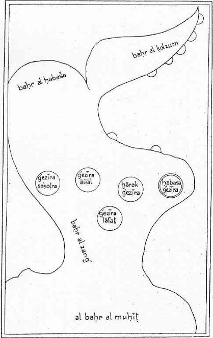
And it is a bay from this sea of India and China in the south of Mount Mandeb (4) and the land of Abyssinia. It stretches from there to the Berbera country [to a position of] its length is sixty-eight degrees and its width is six and a half degrees. And in this bay, huge wave rises, for example, as high as mountains, and most of the time it has been like that. And the island of Qanbalu (5) is from the land of Zanj situated in this bay, and in it is an island of the people of Islam.
P124
Let us mention what is famous and mentioned in the authoritative books. And (including) two great lakes to the south of the equator and the Nile of Egypt comes from there to the north. The western one (=lake) is in a position that is fifty degrees longitude and the southern width is seven degrees latitude, and five large streams are coming from the mountain of the moon and it turns out that the origin of the Nile of Egypt starts with those streams. The eastern one (=lake) is also on the south of the equator in a place whose longitude is fifty-seven degrees and the width is equal to the first one, the same seven degrees south; And the same amount of rivers that flow from the mountain of the moon, and the rest of it will be mentioned in the heading the river Nile, God willing.
P125
Lake Kura
(6)
Ibn Sa'id (7) says that it is a lake on the equator from which three Niles emerge. The Nile of Egypt to the north, and the Nile Mqdshv (=Nile of Mogadishu)(18) to the east, and the Nile Gainao (Nile of Ghana) to the west. And a great mountain, which is called Jabal Makhasam (8), turns around this area from the east and south, and from the end of that mountain, the Nile of Mogadishu (18). (It goes to the east and the water that comes out of the two mentioned seas flows like this. But Sharif Idrisi (9) says that what Ibn Sa'id (7) repeated it is from here the departure of the Nile of Mogadishu (18).) And about the Mogadishu Nile from Lake Kura (6), Ptolemy mentioned that in the original books of this subject that are among his works; [these other two rivers] he did not have them and thought that the same Egyptian Nile was coming from that place towards the north, and that was the only one; and the so called Nile of Ghana from the end of this mountain Muqassam (8). And in the book Rasm al-Ma'mour (10) it is said that this lake Kura (6), is a circular sea on the equator with a diameter of two degrees. And its center is on the equator in a place whose length is fifty-three degrees and a half, and Allah knows best.
P138
The water of the Nile increases when the water in other rivers decreases; and its source is from the south of the equator from the mountains of the moon, [And no one has reached the source of the water, and the way is impossible. Ptolemy gave the following text: This is from the Mountains of the moon]. It consists of ten streams, between each river and the other, a degree in length. The most western ones are at a length of forty-eight; and the second at the length of forty-nine. Accordingly, so that the tenth river of it is at fifty seven degrees. And these rivers flow in two Batiha (=lakes-swamps), each five streams in a section in a Batiha as was mentioned; the western Batiha is at a position that is fifty degrees longitude. [And south of the equator seven degrees. And the eastern plan to a position whose length is fifty-seven degrees] And the same width as seven degrees south. Then from [these] two Batiha come out four rivers and two other streams are connected to them from other rivers. And these six streams reach to the north until they reach the circular lake near the equator, which is called Kora Lake, and its position is where the length is fifty-three degrees and the width of the equator is (seven degrees). And the Nile of Egypt goes out of this lake of Korah to the north and passes through the land of Sudan.
P175-6
Jabal al-Qamar
On the [west and south] side of the equator, there are many mountains connected (to) each other (which) are called Jabal al-Qamar and attributed to the moon, which is the moon. And in some cases, they write it with with damma of the qaf and sukun of the mim (20). And the position of this mountain is said to be eleven and a half degrees from the equator on the south side. And the beginning of its western side is from a position whose length is forty-six degrees and a half, and it stretches to the eastern side of its eastern side to a place where its length is sixty-one degrees and a half, and the width is still eleven degrees and a half. On the south of the equator, which is the north side of the mountain. And no one has reached the south of this mountain. The situation is not clear. But its length from the west side to the east side according to this definition is fifteen degrees, which was approximately three hundred farsang (2). And the sand and stone of this mountain is reddish, and many streams branch off from that mountain, as was said in the mention of waters.
P225
(About Aden) And it's a space in the middle of a mountain by the sea, and the mountain is surrounded by space from all sides, and a door is cut in the rock to the side, and from the sea it is such that large ships come through it ashore easily. Due to that, it became a place of trade and ships from China, India, Persia, Iraq, Egypt, Syria, Abyssinia and Zanzibar came together in that place and offload (and Mghas Lulu(Bahrein) as well, because of its fame). And the sea that is near Aden is the pearl mine. And it is a famous mountain from the mountains of Yemen from which agate and onyx come. And it is said that it is a stone that they know and break and grind and bring out agate and onyx.
P235
(about Qulzum (12) Sea) Then be out by Ethiopia opposite Mecca and Medina, to the end Aden and the Bab el-Mandeb (4) channel. And then [the Ethiopians] it reaches the land of Nubia, and from there it becomes the land of Zanzibar. After that, the width of the sea will increase from the south as it crosses the equator and beyond. And God knows it is not clear.
P239
After that, this sea crosses the equator on the south side, and on the south, it passes through Zang, no one has reached the shore in the east of Zang, and the other side is not known. And on this coast which is on the east of the Arab land is the land of Oman; And on the end it is on the north side of Ibadan. After that, the estuary of the Tigris……
P244
After that, the coast of the sea reaches Zanzibar from the past Bab al-Mandeb (4), and leads to Zanzibar, the coast of the sea. And Zanzibar is a dry province, it has few mansions and agriculture, and the western people of this sea are a total of black people. And the coast of this sea should be crossed to reach Aden. Leopard skin and other colored skins such as jujube and giraffe etc. should be brought from there and most of the residents of those places are at war with the Muslims. You will not find too much material to take from that place; and the people of Zanzibar should not have too much knowledge and art, but the people are strong and powerful.
P289
(about the Nile) And this water is from the south of the equator from Jabal al-Qamar to the province and it turns around of most mountains, it passes over the mountain and cuts about a thousand miles to reach the land of Egypt.
P313
(about Ayzab)(13) These are some of the land of Egypt, and some of the land of Beja (14). But has long been in the hands of the rulers of Egypt and the court of the ship's position is (and) merchants of Ethiopia and Zanzibar and Aden, Yemen come ashore there. And of everyone of Egypt that by sea will go to Mecca, and Jeddah (15) which is twelve miles from Mecca takes in Ayzab (13) ship to come in the Arab country to the beach.
P319
(about distances to Egypt) And many merchants from Egypt go to the provinces of Nuba, Berber province of Ethiopia and Zanzibar for business, most roads of it are desert. And the Maghreb countries, which are to be reached by sea and land, and the land is mostly desert. These are the Egyptian distances.
Vol 2 p 127
…. As they say, in the whole of Fars (21), you will not find any place more expensive than Siraf (22). And you built everything with plaster and baked clay, and the teak and ivory that you brought to the ship from Zanj were used for the mansion there. Until the end of my life, I was thinking about this sentence. After that, the fathers of the Emir of Kish (23) took over the Qais Island and other islands.
……………….. When the situation became like this, the merchants did not stop at Siraf ………….. On the way to Siraf, they didn't bring anything but giraffe leather and a few goods that were special to Fars. Because of this, Siraf was ruined. And Siraf has many regions and deeds, but the hot sea is huge and they do not have running water, and their grain is poor and they drink rain water. …..
Note: this last paragraph is copied from: Ibn al-Balhi: Fars-namah (1117) (history and geography of Fars)(21)
Note: Guy le Strange says ‘giraffe leather’ is here a mistake and proposes ‘and the pots’.


Hafiz I Abru; Zabdat al-Tawarikh
(Butter of History) (1420) Herat
---------------------------------------------------
Taken from: https://www.noorlib.ir/view/ar/book/bookview/text/17650/1/623
During the war of Hussein, the grandson of the Prophet Muhammad (pbuh) against the army of Yazid (16), the following is mentioned:
Ali Al-Sabah who overcame the king of China and the troops of Zanzibar; turned to rebuild Jahangiri (17)…..
(1) Masalak al-Mamalak: see my webpage on Istakhri (957)
(2) farsakhs: Parasang: 1 parasangs or farsakhs = 2.8 nautical miles/ about 5km.
(3) Kish; Qish: Kish island is located in the Persian Gulf, 19 km from mainland Iran, and has an area of approximately 91 km2. It was very important in early Abbasid times.
(4) Mount Mandeb: Bab al-Mandeb: is a strait between Yemen on the Arabian Peninsula, and Djibouti and Eritrea in the Horn of Africa.
(5) Qanbalu: The island of Qanbalu from where the Zanj slaves were imported till the great Zanj revolt in Basra. (Zanzibar or Pemba)
(6) Lake Kura; Kuri lake: lake Koura: Ibn Said mixes up the third lake at the sources of the Nile with lake Chad. From which emerge the Nile of Egypt, the Nile of Magdasu and the Nile of Gana (according to Ibn Said).
(7) Ibn Sa'id: see my webpage on Ibn Said (1250)
(8) Jabal Makhasam: The mountain Muqasam: literally symmetric; also found in Ibn Al Wardi (1348); Hafiz I Abru (1420); Ibn Said al Maghribi (1250); Al Idris ; Ouns al Moubhadj (1192).
(9) Sharif Idrisi: see my webpage on Idrisi (1150)
(10) Rasm al-Ma'mour: Might be Al Kindi (866): Kitab fi rasm al - ma'mur min al Ard. Book of the drawing of the inhabited world. (not extand). Or Abulfida refers to the Rasm al-rub al-ma'mur (Drawing of the Inhabited Quarter) as a book attributed to Ptolemy and put into Arabic for Ma’mun.
(11) Mount Qaf: in Arabic tradition is a mysterious mountain renowned as the farthest point of the earth.
(12) Qulzum sea: located at the head of the Gulf of Suez.
(13) Ayzab: Aidab: Aydhab: medieval port of the Red Sea controlled by Egypt.
(14) Beja: in N Sudan. The Egyptians leaving from Aswan; the southern border town on the Nile; have to cross their territory to reach the harbours on the Red Sea.
(15) Jeddah: town at the shore, close to Mecca.
(16) Yazid: Yazid ibn Mu'awiya ibn Abi Sufyan, commonly known as Yazid I, was the second caliph of the Umayyad Caliphate. He ruled from April 680 until his death in November 683. See also my webpage The Hikayat Muhammad Hanafiyyah (15th); Abu Mikhnaf (680).
(17) Jahangiri: the government.
(18) Nil of Maqdishu: Nile of Mogadishu: This is the Shabelle River begins in the highlands of Ethiopia, and then flows southeast into Somalia towards Mogadishu. Near Mogadishu, it turns sharply southwest, where it follows the coast. Below Mogadishu, the river becomes seasonal. Al Zuhri : (1137) Makes the people divert themselves the Nile into a branch to the sea of Yemen; In Dimashqi (1325) it is called the river of Damadim; and he is the only one who kind of understands the river-system in South-Somalia. Salamanca translator (1420): calls it yellow Nile. Ibn Khaldun (1406) says it has nothing to do with the Nile. Nile of Mogadishu appears in Ibn Said al Maghribi (1250); Cowar el-aqalim (1347); Abulfida (1331); al Maqrizi (1441)he calls it River of the Damadim ; Hafiz I Abru (1420); Qoutb al-Din al-Chirazi (1311); Al Qalqashandi (d1418); Qadi Ibn Sasri Al-Shafi’I (1300) Cowar el-aqalim (1347).
(19) Kerman: known in ancient times as the satrapy of Carmania, is the capital city of Kerman Province, Iran.
(20) Dammah: damma is the vowel u in Arabic ; Qaf: qaf is the letter: K ; socoun: small sign on top of a letter to show that the letter has to be joined with the preceding one to form a syllable; mim is the letter M.
(21) Fars: region in Iran.
(22) Siraf: was the harbour of Shiraz province of Persia; and the place of big trade with East Africa.
(23) Qish: Kish island is located in the Persian Gulf, 19 km from mainland Iran, and has an area of approximately 91 km2. It was very important in early Abbasid times.