The Pyralax Islands and the Channel
Back to table of contents
Notes on Periplus of the Erythraean Sea
(part concerning East African coast)
-----------------------------------------------
Periplus: Greek word meaning circumnavigation
Erythraean Sea: The Indian Ocean
The Periplus of the Erythraean Sea: Is a merchant guide for the coasts of the Indian Ocean.
Paragraph 12
---------------
"cinnamon and frankincense"
North of Azania at Cape Guardafui (Cape of Spices) is the spice country, or cinnamon country. Two spices are mentioned, cinnamon: the oldest spice used by men and till today much used. The
second being frankincense which is a resin extruded from the frankincense tree,( see paragraph 29) and in ancient times, a very expensive article. It was used as an incense, in religious
ceremonies. There are several references to its use in the bible. In Egypt it was also employed in funeral rites.
Cinnamon however does not grow in Africa or Arabia. It is imported from India. For that reason it seems necessary that the Indians had at least a foothold in the area as middleman to sell
the cinnamon to the Greek-Egyptian -Arab-Roman vessels.
Paragraph 13
----------------
"marked town called Opone"
We can safely say that this place was in the southern bay of the promontory of Ras Hafun. Also, further south there is no other place usable as harbor.
Paragraph 14
---------------
"month of July"
From June to September one has a favorable wind blowing from the North to descend the Red Sea. Halfway October one then catches at the Cape of Spices the North eastern monsoon.
"Ariaca and Barygaza"
this is the north-west coast of India, the modern Cutch, Kathiawar and Gujerat.
"clarified butter"
also called ghee, (Samli in Swahili). It is formed by heating butter for a whole day and taking of the oil, after the water has been evaporated. It is stored in earthen pots while it is still
hot. It can easily remain usable for several months.
"honey from the reed called sacchari"
Here an indication that sugarcane was already imported in east Africa early on.
Paragraph 15
---------------
"the small and great bluffs of Azania"
Bluffs means cliffs.
The small bluffs are now known as El Hazin
The great bluffs are now known as Sif El Tanil
The periplus is originally written in Greek, but also Latin copies are found. They give the word Apocopes for bluffs.
"small and great beach"
The small beach is now known as Barr Ajjan
The great beach is now known as Benadir coast
"and this course is of six days"
a course is the distance a boat sails in one day till it reaches the next safe place to land.
Idrissi, a thousand years later took 100 miles as the average course for a ship (in 24 hours sailing).
Captain M. Guillain, a ship captain send by the French government in 1846 to survey the East-African coast was able to calculate more exact figures.
When the monsoon wind blows in the right direction, from Ras Hafun on, one can count on a speed of 2,5 to 3 miles an hour to which you can add the speed of the current in the water of 1,5 miles.
Making the boat move at 4 miles an hour (or 48 miles a day) And this figure counts for the first 12 days of the trip (starting from Opone) After that the current in the water gets stronger,
reaching 2 to 3 miles an hour. Ships then move at 5 miles an hour or 60 miles a day.
"Sarapion"
M Guillain puts it at the ruins of Quarcheikh, well north of Merka. He also gives a sketch of the ruins and harbor (abandoned) that he found there. Other Authors put the place way closer to
Merca.
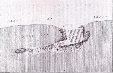
Captain M.Guillain surveyed the east coast of Africa in 1846-1848 for the French government In the neighborhood of present day Italia he found a couple huts and ruins of a medieval town. He suspects that this must have been the place of the old Saerapion. In his days the place was called Quarcheikh, and in Portugees days it was known as Bandel-Velho (old harbor). One of the people on his ship made this drawing.
"two courses of a day and night"
This means that in this stretch the coast has no commercial value, compared with the previous section: the channel, seven anchorages...
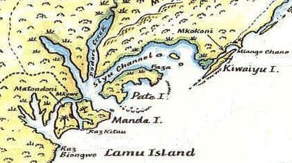
Pemba is 170 nautical miles from Lamu where the channel of the Pyralax islands ends.
Zanzibar is 240 nautical miles from Lamu,
With a speed of 60 miles a day, for two days and two nights, the boats make 240 miles. That would make Zanzibar to be Menuthias island.
"until the Pyralax islands and what is called the channel"
The Pyralax islands are Pate, Manda, Lamu and some smaller ones. The channel is nowadays called the Siyu channel. It is understandable that the boots took the channel instead of passing through
the ocean as it is mentioned in the text that they traded while sailing along the coast.
"along the ausanitic coast"
The supremacy of South Arabia over the East African coast started about 1000 BC. The first nation to rule was the Arabian state of Auson which went into eclipse before 600 BC.
"is the island Menuthias, about 300 stadia from the mainland"
This island is Pemba or Zanzibar. Pemba is 50 km from the coast while Zanzibar 36km.
There were in the Greek world three different definitions of Stadia:
-The Olympic (or standard) being 185 meters
-The stade of Eratosthenes being 153 meters
-The stade of Dio Cassius (AD 180) 197.3 meters
This makes that Menuthias is 55.5 km or 45.9 km or 59.2 km from the coast. According to this criteria then Pemba would be the island.
"mountain tortoise"
The giant land turtle from Madagascar is by now extinct in the islands off the east African coast.
"crocodiles, but they do not attack"
Most probably is meant the giant lizard. (Kenge in Swahili) It is over 5 feet long and harmless. And lives indeed in the islands. While the crocodile does not.
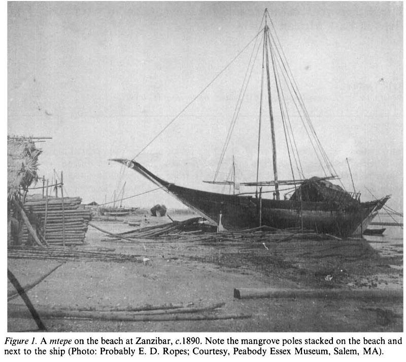
"there are sewed boats, and canoes"
(Swahili Mtebe) in use till recently in Lamu. They are called sewed boats because the planks are sewed together instead of being nailed.
The sixth century Byzantine historian Procopius wrote the following about these boats.
All the boats which are found in India and on this sea (the Red Sea) are not made in the same manner as are other ships. For neither are they smeared with pitch, nor with
any other substance, nor indeed are the planks fastened together with iron nails going through and through, but they are bound together by a kind of cording. The reason is not as most persons
suppose, that there are certain rocks there which draw the iron to themselves , for witness the fact that when the roman vessels sail from Aelas into the sea, although they are fitted with much
iron, no such thing has ever happened to them. But rather because the Indians and the Aethiopians (this is the Greek word for all black-African people) possess neither iron nor any other thing
suitable for such purposes. Furthermore they are not even able to buy any of these things from the Romans since this is explicitly forbidden to all by law.
Note also that the ones used on the African coast had sails made from palm leaves.
"in wicker baskets"
This fish trap ( Swahili: dema) is still commonly used today.
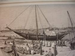
A mtepe; the traditional east-african craft here in Zanzibar 1888 (taken from the official Zanzibar website)
The Romans liked tortoise shell (the shell of the turtle) a lot for the manufacturing of small receptacles, ornaments and also for inlaying furniture and woodwork.
Paragraph 16
---------------
"Rhapta"
Has not yet been discovered. M Guillain thought it was in the Rifuji delta, others put it in Dar es salaam or Tanga, or even the Lamu archipal (James de Verre Allen). Dr F. Chami holds the view of the Rifuji delta and has found already quiet some remains from roman times on the hills north of the delta, on Mafia island and on Zanzibar. The geography of Ptolemy also puts it there and about 40 km up river. If this view will turn out to be correct, then Zanzibar is the island Menuthias.
"piratical habits"
The word to describe the inhabitants is corrupt; it reads rato; Miller suggests peirata meaning 'pirates'; Giangrande; rstai; 'tillers of the soil'.
"very great in statue"
The people of the coast are said to be tall but not much else is said. So they probably were not Khoisan hunter-gatherers. The other possibilities are Bantu, and we know now that it was about that time that the Bantus started settling in the hinterland of the coast. Also the sewn boats are a Bantu invention. Another possibility is the Southern Cushites, who lived in East Africa already for many centuries, and as the trade on the East African shores seems to be way older then the periplus (see the "some ancient right") they must have met the Cushites. A last possibility is Malaysian people who were trading on the coast or who before settling in Madagascar lived on the east African coast. Evidence of their existence at that time is given by the coconuts growing on the coast . See " and a little-palm oil" and by linguistic research which indicates that the Malagasy of Madagascar adopted in the first centuries AD words from the coastal Bantu.
"the Mepharitic chief governs it under some ancient right that subjects it to the sovereignty of the state that is become first in Arabia. And the people of Muza now hold it under his authority."
As mentioned above, the South Arabian states held the supremacy over the East African coast since 1000BC. The first nation to hold it was
-Ausan then
-The Sabean confederation
-Qataban followed by
-The king of the Hadramawt, who also ruled the Sabaean then the
-Himyarites or Mapharitis which was one of the tribes. They were ruling in the days of the periplus. (they also ruled the Sabean)
Together with this overlordship went the title: Maker of covenants. (the most powerful nation was the one pushing through international treaties, the title shifted from one nation to the other as they in turn became powerful.)
This overlordship brought them excessive wealth.
Agatharchides (150BC) has this to say:
No nations in the world were so wealthy as these Gerrhaens and Sabaens, (in NE Arabia, in the gulf) for they have piled up in their treasuries all the riches that they have gained from Europe and Asia. They are the ones that have made Ptolemy's Syria rich, it is they who have, among many other things, made it possible for the Phoenicians to make lucrative deals. Their luxury is not only displayed in marvelous embossed and engraved metal work and in the variety of their drinking vessels but in their beds and tripods, which are also unusually large. This luxury reaches its climax in the many house-hold objects which are known to us while many of these people own royal riches. It is said that they have numerous gold and silver columns, and the doors of their houses are decked with ornaments and jewels. Even the walls between the columns are said to be magnificently decorated.
The Mapharitic chief is called by name in paragraph 22: "Cholaebus". He is the Sheikh of the Ma'afir tribe.
The king of Himyar is called Charibel ( see paragraph 23). He had farmed out the trading rights to the port of Musa near present Mocha. Musa is the port of the province of the Ma'afir tribe ruled by Cholaebus.
Charibel had temporarily unified the Sabaeans with Himyar under his rule.
However he himself had become a subordinate ally of the Romans, who gave him the title: Friend of the Emperors. (See paragraph 23) The Romans put in three of his ports a centurion-tax collector. One of them is mentioned in paragraph 19. Musa however was to unimportant to be a tax collecting point.
What we know more about the king Charibel is that his name is an Arabic title (Kariba-Il) meaning "God bless him". This king, Kariba-Il Watar Yuhanim (Great,Beneficent), was one of the Sabaean kings whose names have been collected from the South Arabian inscriptions. He ruled about AD 40-70.
Paragraph 17
---------------
"lances made at Musa especially for this trade"
This has been interpreted as saying that the coast was still in the stone age. However iron was also imported in Adulis where already for three centuries iron was known. We know now that east Africa in the days of the periplus was going through the intermediate phase of about 500 years between the first appearance of iron and its everyday use.
"Adulis"
The modern port of Massawe in Eritrea
"and rhinoceros-horn"
This was the most valued of all east African products for its supposed aphrodisiac properties.
"and a little palm-oil"
This might be the most important phrase in the book as it shows that the coconut palm must have been introduced into East Africa from before that time. And is another proof of early contacts between Africa and India-Indonesia. The word used in the Latin manuscript is Nauplios which the translator corrected to Margilios, which is the Sanskrit Narikela, Prakrit: Nargil meaning coco-nut . For a long time there has been a controversy over the exact meaning of the word as it can also be read as meaning ' cuttlefish' and 'pearly sea-shells' the discussion is over by now and all agree on 'coconut oil'.
Paragraph 18
---------------
"markets of Azania"
A market does not imply a permanent settlement. The monsoon winds make that only a couple months a year ships can come to the place for trade. People from the interior can take the occasion to show up on these yearly markets.
A town or emporium as Ptolemy calls it is a merchant station. Trade there is organized by the authorities and taxes need to be paid.
"the unexplored ocean curves around toward the west, and running along by the regions by the south of Aethiopia and Libya and Africa, it mingles with the western sea."
This passage shows that the author of the Periplus knew that Africa was surrounded by the ocean and that it would be circumnavigated, although he states also the sea is unexplored.