Note on the Shape of Africa on the Kangnido.
(and other Chinese maps of Africa).
------------------------------------------------
-Ch'uan Chin and Li Hui (1402)
According to me this composite map of the world was (concerning Europe- Africa) composed in the following way:

1: for Europe-N Africa and the Middle East an existing Persian map was used that would have shown about the same geographical area as the contemporary European maps called Portolan-maps. No such maps exist anymore. But European once do.
2: for the part under N. Africa the Chinese had to use a description they found in the works of Arab-Persian authors. I
give two parts of maps produced with the coordinates given by Ibn Said. The first one of the sources of the Nile is from Kramers (1936) the second one of the islands in the Indian Ocean I made
myself.
Both; the islands and lake Kura they added using a different scale.
3: The contours of the African continent that surrounded the sources of the Nile they had to invent themselves starting from the boundaries of N. Africa. Lake Kura is really recognizable. But for the sources of the Nile it must absolutely have been that they added this nearly symbolic representation while having an Islamic map at hand. It seems to be a later change to the map as it is still not present in Chu Ssu Pen’s map, where the river ends up in the lake contrary to the later maps where it becomes the Nile of Mogadishu, ending near Mogadishu and opposite Aden.
4:To make the composition fit into the complete world-map Africa and Arabia get stretched out with a big space devoid of inscriptions. The reason for this is unknown but might have been something simple as to bring the islands of the African coast into a more acceptable position. (In the work of Ibn Said the Africa Islands are to the South of India.) That the Koreans making the map did not take care of the scale used in the different components is mentioned by Gari Ledyard in: Cartography in Korea (p284): “Precisely because the Koreans had foreign maps but lacked any sense of their relative scales, their incorporation of them into the Kangnido created distortions in the relative sizes of China, Korea, and Japan (just to confine ourselves to the East Asian portion of the map.)”
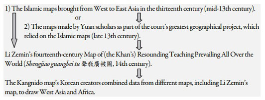
Note: “The World Map Produced in Korea in 1402 and its Possible Sources from the Islamic World by Hyunhee Park.”
Here the following short text is given on how the Kangnido was partly build from Islamic sources (p5).
For this transfer see also my webpage: -Zha Ma Lu Ding (13th)