Jub
----
Note: Djoubb (El Jub); Jubb : a dug, non-masoned waterhole (according to Marcel Devic p70); the name still exists in the name of the river Jubba. Must have been close to present day Kismayo. Is mostly mentioned by Chinese authors: Yakut (1220): town of Djoubb; Al-Dimashqi (1325) speaks about the rivers small and big Djob or Gubb; Al Firuzabadi (1414) Jibbeh; Ibn Madjid (1470) has the island of the region of Djubb; Fei-Hsin (1436) has Giumbo; Xuanzong Shih-lu (1438) has Zhu-bu; Zhang Tingyu: Ming Shi (1739) has Chupu; Luo Maodeng (1597) has Zhubu. Some authors say the channel mentioned by al Masudi (916) is the Jubba: “…Zinj were the only ones who had crossed a tributary of the Nile (the Jubb) which flowed into a bay or canal, which in turn opened into the Indian Ocean…”.
The place has never been found. The fertile, irrigated heavily populated land of the navigable Juba river must have had a harbour. About this irrigated land:
Taken from: Swahili Origins: Swahili Culture & the Shungwaya Phenomenon by James De Vere Allen.
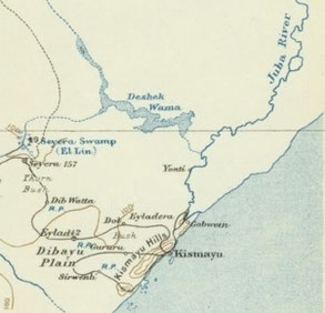
The ruined-site on the Lower Juba near Deshek Wama. The notes of the nineteenth-century missionary Wakefield who visited this place (which he knew as Keethi or Kyrthie and which Elliot, the British administrator in the 1920s, spelled Kedi) are said to have described it as having stone houses and seven gates and two- three days from the coast. It is beyond any reasonable doubt the place which is remembered in the Book of the Zinj as Shungwaya. It mentions that Deshek Wama and Shungwaya were the last places where the Kashur were able to hold out, but they had eventually to flee from the Gala. No modern account of this site exists, and we do not know when it was founded, through it was probably abandoned c. 1715. Deshek Wama is a fertile, shallow depression about sixteen miles long by two miles wide, which was irrigated from Lac Dera and also through a permanent channel from the Juba. It used to be a dry-season grazing ground and was also used by cultivators.
Taken from: Thomas H. Wilson; SITES AND SETTLEMENT PATTERNS OF COASTAL JUBALAND, SOUTHERN SOMALIA
The Juba River is navigable for a great distance, although sandbars at the mouth complicate entrance from the sea. No sites have come to light around the river's mouth, perhaps because Kismayu, on a bay 16 km to the south, then as now functioned as the Juba port by providing the shelter (save port) the mouth lacks.
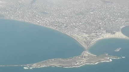
Old Kismayu stands as the northernmost site in coastal Juba- land, located on and behind the headland known as Cape Bissell to the east of Kismayu town. The high rocky coral headland of the cape joins the mainland by a neck of low-lying sand dunes. On the heights of the cape Revoil visited a ruined mosque and tombs as well as "vestiges of the ancient habitations" (1888:395). At the time of Elliot's visit the mosque had been dismantled and the stones of the walls and kiblah removed to Kismayu (1926 159-163). Near the interface between the coral promontory and the dunes Elliott found a cemetery exposed by erosion in the sandy cliff face at a depth of about 1.5 - 2 m below the surface. He saw human bones/ ceramics, cannonballs, and beads of carnelian, turquoise (?), glass, bone, and ivory. He traced an apparent water duct by digging, and reported (house ?) walls nearby and a possible landing place of masonry. His ceramic collection appears to include celadons, white and blue and white porcelains, Islamic monochromes, and stone wares. As a group these suggest the I5th and I6th century period, if the ascriptions are correct. The apparent depth of the deposit and variety of artifacts at Old Kismayu suggest that the location would repay archaeological investigation. It may well be the site of old Juba. …….. The only mention of ruins on Kismayu Island is by Grottanelli (I955a p76), who wrote of ruins "on the small island now uninhabited that closes (Kismayu Bay) at the north."
……… the Juba mouth with no site yet discovered near the only major river of southern Somalia and with no large sites around the only feature that can be called a bay in the entire region. One might expect sites near the river mouth, given the fertility of the Juba valley and the opportunity for navigation upon the river in spite of the sandbar at the mouth. Old sites could have been destroyed by fluvial or marine action or concealed by dunes; alternatively, the course of the river might have shifted, creating a new mouth. Perhaps Old Kismayu, offering the shelter the mouth of the river lacks, functioned as the port for the river, with much of the old site cannibalized for construction in the present town.
Note: During the Middle Ages, Kismayo and its surrounding area was part of the Ajuran Empire that governed much of southern Somalia and eastern Ethiopia, with its domain extending from Hobyo in the north, to Qelafo in the west, to Kismayo in the south.
Note: Ibn Majid was most probably an eyewitness: The first thing that you find in this gulf is the island of the region of Djubb. And indeed the Island of Snakes (the island in front of Kismayo) is the first of the Bajun islands. And Djubb is the name of the region through which the Jub river runs; no town or island or port with that name.
Snake island in front of Kismayo harbour. Last century ruins of old Kismayo were seen there. Cape Bissell is the point that connects the island to the mainland.
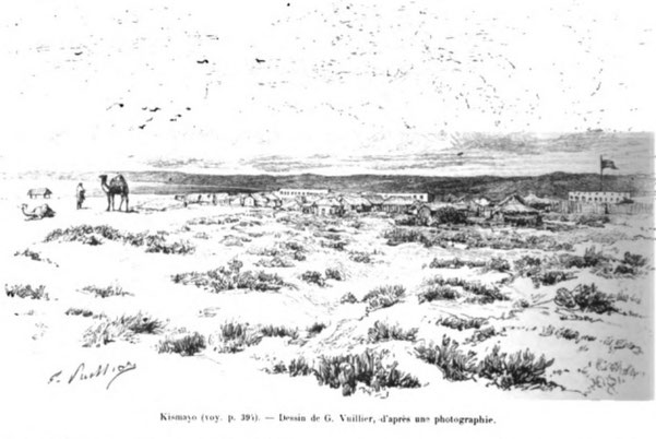
Taken from : Revoil G., Voyage chez les Bénadirs, les Somalis et les Bayouns en 1882 et 1883 ; Le Tour du Monde, 1888, tome 2, Paris, pp. 385-416.
P395
(After arriving in Kismayo)
I arrive at the governor’s place at the time of the barza. Seyd ben Seyd, a relative of Said-Bargach, is a very affable young man. His reception was most cordial and he offered me hospitality at his home. I thought I should refuse, because I expected to receive a crowd of Somalis and I did not want to be indiscreet. I preferred to lodge at Ismail's, a brave Indian, director of customs, and resident in Kismayo for a long time. No one better than he could give me information on the country, as well as serve as my guide in the city and the surroundings. We went first of all to visit together the ruins of old Kismayo on the heights of Cape Bissel. In the middle of brambles and thorns, we ended up discovering the remains of ancient dwellings and even an old mosque surrounded by tombs. But no inscription gave us the date of these ruins. However, the method of their construction in coral and lime allows us to attribute them to the navigators of the thirteenth century. I only collected a few fragments of coarse and shapeless pottery, at the same time several terrestrial shells similar to the helices and bulimes collected on the heights of Moguedouchou.
End of the Middle-Ages View by the Portuguese.
Taken from: João de Barros; Asia: dos feitos que os portugueses fizeram no descobrimento e conquista dos mares e terras do oriente : Década Quarta.
P272 (decade4-book3-chapter3)
(in 1536) And on the way he (Nuno da Cunha) sent Diogo Botelho to go to the place of Jubo, which crosses the Equinoctial line, sixteen leagues (5.5km*16) almost short of the City of Brava, where, according to what they told him, there was a bargantim (type of ship) in which there were many Portuguese, who from India, …… Diogo Botelho did not find them, and returned to Malindi with a ship that had left there about fifteen days previous ……
P307 (decade4-book3-chapter9)
And Luiz de Andrade sent a caravel, of which he was Captain, to a place near there, which was called Jubo, in search of a galleon from Rumes (Turks), which had come to that port in time, which made Luiz de Andrade go to the coast, he fought with him and he took a lot of pepper that they brought from Java, ……
P79 (decade4-book6-chapter14)
(Manoel Moreno in 1535-6)
Having taken in water, and food in a port called Jubo, he left, and went to Cape Agulhas (S Africa), which is two leagues of land, where he was hit by such a severe storm from the South, that he arrived twice, and found himself completely lost. Because the seas were very thick, they entered one part of the ditch and left the other, and miraculously he escaped. During this same storm, the Cape of Good Hope was doubled ……