End of the Middle Ages View on Sailing Times to and from East Africa by Ahmad ibn Majid (1470); Sulayman al-Mahri (1515); Sidi Ali Celebi (1554).
------------------------------------------------------------------------------
Shihabal-Din Ahmad ibn Majid (1470) is the uncontested Arab authority on navigation. See my different webpages on him.
Sulayman ibn Aḥmad ibn Sulayman al-Mahri was a 16th-century (1480-1554) Arab navigator. He came from Shihr, in Hadhramaut, eastern Yemen, and he was called “al-Mahrī” because he was a descendant of the Arabic tribe of Mahra.
Seydi Ali Reis (1498–1563), formerly also written Sidi Ali Reis and Sidi Ali Ben Hossein, was an Ottoman admiral and navigator. Known also as Katib-i Rumi, Galatalı or Sidi Ali Çelebi,[1] he commanded the left wing of the Ottoman fleet at the naval Battle of Preveza in 1538. He was later promoted to the rank of fleet admiral of the Ottoman fleet in the Indian Ocean.
Taken from: Adwa Eala Tarikh al Yaman al Bahri (Lights on Yemen's Maritime History) - أضواء على تاريخ اليمن البحري Hasan Saliḥ Shihab 1981
Ahmad ibn Majid (1470)
Traveling to the Zanj from India to the Zanj in 320 to 30 days From Ash Shihr to the Zanj after the Indian journey in 20 days From Dhofar From the first morning wind to the seventieth of Nayrouz(1) Traveling from the Dhiba Islands - Traveling from them when the rains (Bashkal) have stopped or become weak. Rains on these islands are almost non-stop throughout the year. From the back of Shamtar Island to Dhiba in the sixtieth of Nayrouz and there is no good after that. Traveling from the Comoros Island (Madagascar) to the Zanj Traveling from the Comoros Island to the mainland of the Zanj has two seasons: the beginning of the Kos at the beginning of the Kos, and the end of the Kos when it is also weak. However, those who are south of the equator and want to travel at the end of the Kos to the northern regions face rains up to the equator. Likewise, the journey from (Safalah) and (Al-Ahwar) to the Zanj is the season for the East Indies - from the Moluccas to Ghor, Java, and all the southern islands at the end of the Kos. These are the travel seasons mentioned by Ibn Majid in his book (Al-Fawa'id fi Usul 'Ilm al-Bahr wa al-Qawa'id).
Sulayman al-Mahri (1515).
The first season of al-Kaws, which is called (Ra’s al-Reeh= Wind),
… (from)Zanj (to) Guzerat, al Mishqas (2), and Aden; at 150 Newroz …
… (from) Zanj (to) Hormuz (on) 290 Newroz (1)
… (from) Mogadishu (to) al Dhayboh (on) 310 Newroz
… (from) Zanj, (to) Dhofar, al Mashaqas (2) al Sohar and Aden (on) 315 Newroz …
Also signs at sea that the land is near:
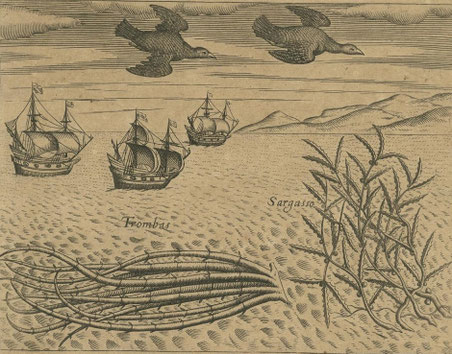
As Illustration only: From Theodore de Bry of Frankfurt 1598-1603.
Seaweed and more birds seen [approaching the Cape of Good Hope] during the voyage to India.
The sailors saw many plants floating on the surface of the sea during their voyage to India. Among these was the trombas, which was a pipe-like growth with its roots floating free in the
water, also the Sargasso, which was a large seaweed with pointed, serrated leaves. The birds included one which was black and white, with a grey bill. The sight of this bird, along
with the trombas, was a sure sign the ships were approaching the Cape of Good Hope.
1. Marzah
Marzah, according to mariners, is a sea snake. It appears from 10 to 5 feet (10 km). It is either terrestrial or marine. The terrestrial species appears four zams (10 ft) from the coast of Juzrat and at a depth of sixty cubits (10 ft). The marine species appears approximately eight zams (10 ft) from the coast and at a depth of one hundred and twenty cubits (12 cubits). The most accurate is the one that appears at a depth of two hundred and twenty cubits (12 cubits). The marine species appears sixteen zams (16 cubits) from the coast of Kankan and Talawan, and the terrestrial species appears eight zams (12 cubits). This is the well-known phenomenon—as Al-Mahri said—in ancient times, and has been tested in all lands and times. However, in this era (Al-Mahri's era), its sign has changed from what is usual and has no standard. Sometimes you see it at a distance of thirty zams (10 cubits) or twenty-five zams (10 cubits) from the coast, or more or less, and sometimes you see it as it used to be. The bottom line is that these days, as we saw it in ancient times, it is not a single rule. The Marza is a sign of the proximity of the Siam coast, and appears there from Jah 7 to Jah 9.5, sometimes seen more than others. The Marza appears from Jah 11 to Jah 12 between (Zajd) and (Ras Al-Hadd) (=11) and between (Muscat) and (Dewal Sind) (=12). The appearance of the Marza does not stop there from land to land. Likewise, the Marza appears on Jah 4 between the Malabar coast and Ras (Guardafui), and from the back of (Dhiba) to (Guardafui), and from the back of (Al-Dhiba) to the coast of Somalia. Therefore, it is not correct to take it as a sign of the proximity of any land to the land from the position of eleven to the position of twelve, and likewise the land on the position of four. Also, there is no validity to the Marza of the Arabs, which sometimes appears near Suqra, Sajir, Furtak, and Socotra, because it only appears rarely and what is rare has no rule, and because it also appears sometimes near the coast and sometimes far from it, likewise there is no good in a dead Marza.
2 - Birds, Whales, and Grasses.
Among the signs of the proximity of the Arabian Peninsula are the crane and the dafik. Among the whales are the large but not the small squirrel and the tabaqah. Among the plants are the qarmut and the qalhaf. Among the signs of the proximity of the Somali Peninsula are the manji, the crane, the sloth, and the daghat if they are numerous. Among the whales are the large squirrel, the tabaqah, the seahorse, and the ajam, which is a whale close in size to the batan. It is one of the marine signs that also include the shark, the large thamud, and the aqam. Among the plants are the qarmut and the talhaf. On a position of three and two fingers, you can sometimes see some land whales, such as the sarak and others. Among the signs of the Zanj Peninsula are the crane and the manji, and the crane is closer to the coast. As for the bird known as Umm Al-Sanani, which is a blue bird with a white belly tinged with blue, it is not considered. It appears at the coast of Socotra, but neither it nor Al-Munji appears between Socotra and the mainland.
3 - The tide (of water) and the waves of water
Among the signs of the nearness of the mainland and the ebb are the waves, which are found in all places, and are abundant at protruding headlands in the sea, and at low tide, such as the islands of Al-Fal (like Al-Dha’ib), Al-Dhiba, Naj Bari, Socotra, Ceylon, Sumatra, Java, and others. The waves of water are also among the signs of the nearness of the mainland and the ebb. Among the signs of the nearness of the mainland are many trees resembling palm trunks. ……
Sidi Ali Celebi (1554).
Taken from: Journal of the Asiatic Society of Bengal, Volume 3 – 1834.
Extracts from the Mohit, that is the Ocean, a Turkish work on Navigation in the Indian Ocean. Trans. By Von Hammer from the work of Sidi Ali Celebi (1554).
Monsoon end of Kaws called Tirmah or sometimes Damani.
34. The monsoon from the Sawahil and Maukadash to Jazreddib (the Maldives) sets in about the 320th day of the Yazdajirdian, that is to say, the 185th of the Jalalian year (21st Sept).
Eastern monsoons called Azib
48. The monsoon of Melindi to Jazrul Kamr (island of the Moon) blows from about the 80th to the 100th of the Yazdajirdian year (1); that is, from the 310th to the 330th of the Jalalian (24th Jan.- 13th Feb.)
49. The monsoon of Kilui (Kilwa) for sailing to Sofala, blows from the 10th to the 60th of the Yazdajirdian, that is, from the 240th to the 290th of the Jalalian year (15nov-4th Jan.)
50. The monsoon from Sofala to Kilui, blows from about the 160th to the 190th of the Yazdajirdian year (1); that is to say, from the 25th to the 55th Jal. (14th April – 14th May). The finest lasts till about the 170th Yazd. 35th Jal. (24th April.)
Note that the dates given are 10 days later then in the Umdat of Suleiman ibn Ahmad.
Taken from: Relations de voyages et textes géographiques arabes, persans et turks relatifs à l'Extreme-Orient du 8e au 18e siècles; traduits, revus et annotés by Ferrand, Gabriel, 1913
SEA ROUTES OF THE ISLANDS
Sea Routes of Komr Island.
The sea routes of Komr Island are as follows. It should first be mentioned that it is a very large island and extends along the coasts of Zandj and Sofala. It begins in the north, at the cape called Ras-i-Milh, which is located at the point where the Big Dipper is 11 degrees above sea level. Its southern part is called Hufa. This is located at the point where the Big Dipper is 3 degrees above sea level, according to some; 1 degree according to others, which is correct. Regarding the sea routes of this island, there was no agreement (there were differing opinions), because it is uninhabited. The sea route on the outer side (lit.: the back) which faces the [high] sea [—eastern coast], is, according to some, southwest-1/4-west; according to others, southwest; in the opinion of the Ancients, from beginning to end, west-southwest; the author thinks, [on the contrary,] that according to all probabilities, the route is west-southwest, [then- southwest-1/4 west and [finally] southwest'. There are, moreover, two remarks to be made. One is that the island is extremely large, the coast is endless and the sea route is also endless. The other remark is that it was unknown what the sea routes really were because few people went that way and because those who did had little knowledge of nautical art. The Zandj pilots said: The sea route on the outer [= eastern] coast of the island goes from Ras-i-Milh to the place where the Big Dipper is 8 degrees high, to the south; and from there, to the end, to the southwest 1/4-west; the route on the inner coast [lit.: the belly = western coast] of the island goes from Ras-i-Milh to the place where the Big Dipper is 8 degrees high, to the southwest 1/4-south, and from there to the end of the island, to the southwest 1/4-west. The inner [= western] coast, from Ras-i-Milh to the place where the Big Dipper is 6 degrees high, is entirely nadif, that is to say that there the coasts are healthy. On the contrary, from there to the place where the Big Dipper is 6 degrees above sea level, up to 2 zam or a little more from the end [of the western coast], [the coast] is rikk [or rukk], that is to say, there is no bottom. On the [African] continent side, between the coast of the continent and that [of the island of Komr], are four large islands; they are inhabited and close to each other. The Zandjs go there. The name of the first island is Angazidya; it is at the place where the Big Dipper is 11 1/4 degrees above sea level. It is 16 zam [=48 hours' drive] from the continent. The second island, Mulali, is located at the place where the Big Dipper is 11 degrees above sea level. The third, that of Dumuni, is east of Mulali, where the Big Dipper is also at an altitude of 11 degrees. The fourth, that of Mawutu, is where the Big Dipper is at an altitude of 10 and a half degrees. The above heights of the Big Dipper are only valid for our time, because it moves, as already indicated, with the apogees. To the east of the aforementioned islands, there is a large bank located in the open sea, about 4 zam [from the western coast of Madagascar], which is called 'ayn al-bahr. The ports on the inner coast [= west of the island of Komr] are: Langani Sa'da and Manzalagi. Those on the outer coast [= east] are: the port of Bani Ismail and Bimaruh. They are all dangerous for ships, with the exception of Langani. Let it be known that Ras-i-Milh is 50 zam ==150 hours' journey] from the coast of the Zandjs; that furthermore, about 20 zam to the east of Ras-i-Milh, there is an inhabited island, called Munawwara; and that in the south-east of the island of Komr, there are numerous islands called Tir-i-Rakha, distant 12 zam from the island of Komr.
(1) Nayrouz, Newroz: Persian new Year; =Yazdajirdian year.
(2) is Wadi Hadhramaut at its mouth into the sea now called Wadi Masilla.