Kalfa (Kilifi)
-------------
Ibn Majid (1470) is the only author to mention the place.
Taken from: THE MONUMENTAL ARCHITECTURE AND ARCHAEOLOGY OF THE CENTRAL AND SOUTHERN KENYA COAST by Thomas H. Wilson, Ph.D.
Kitoka, on the north bank of Takaungu Creek, along with Mnarani on the south bank of Kilifi Creek and Kilifi on the north bank of the same, were the settlements of the old "city state" of Kilifi (Kirkman 1959). A fourth site name known for the area is Kioni, which Kirkman first (1959:95) equated with Kitoka but later considered a separate site near the sea on the south bank of Kilifi Creek.
Kirkman (1975) wrote of Kioni that "the capital of a mihrab was found with an inscription in interlacing Kufic, which may be older than the fourteenth century," That is all I know about Kioni, which will not be considered further here.
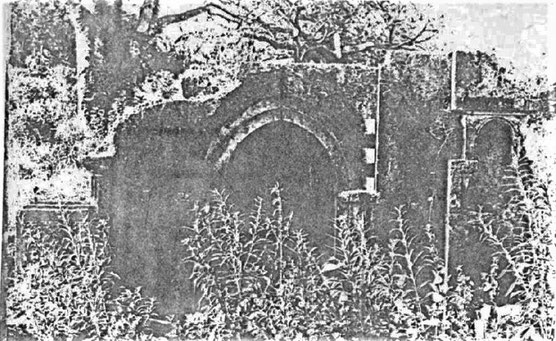
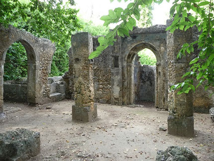
Kitoka is a site of two mosques and numerous houses, today covering an area of about six acres, although it is likely that in the past the site was considerably larger. plans of the two mosques and elevations of their mihrabs were presented by Garlake (1966: Pigs. 35, 36). The mihrab of the large mosque is still in good condition ….
During two trips to Kitoka I was not able to find the small mosque illustrated by Garlake; I believe it was overgrown or, more likely, now completely destroyed. ……
Doorways in the houses of Kitoka were usually framed by architraves, often with single niches in each of the pilasters. The archways themselves were often once or twice recessed from spandrel level, either including the jambs or above the level of springing only. …..
Kitoka houses also sometimes displayed panels of niches constructed of cut coral, ….
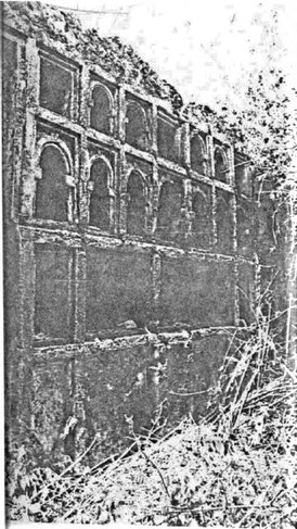
Left: Kitoka: Large panel of niches in a private house.
Top:The large Mosque at Kitoka.
As nothing remains now from the ruins, I only have some old pictures to share of these ruins from a later period then the Middle Ages.
Taken from: THE IMPACT OF DEVELOPMENT PROJECTS ON ARCHAEOLOGICAL HERITAGE: A CASE STUDY OF SELECTED COASTAL SITES AND MONUMENTS IN KENYA by BUSOLO NAMUNABA
The Kitoka site on the other hand is located on the north bank of Takaungu Creek near Mnarani, Kilifi and Kioni on Kilifi Creek. When Garlake (1966) visited the site in mid 1960’s the site covered about 2.5 hectares and comprised two ruined mosques and a number of houses. In the 1970’s and early 1980’s teams from the National Museums of Kenya visited Kitoka but one of the mosques had been demolished. According to Wilson and Omari (Op.cit.) the owner of the land on which Kitoka is located threatened the site by clearing and cultivating the area and was hostile to the concept of preservation of any kind on his land.
Kitoka ….. ruins still hidden in the forest that were unexplored... when the Portuguese arrived the two were just but villages …. Rodwell, Gedi The lost City (1946).
Kitoka, together with Kilifi and Kilepwa made up the old State of Kilifi, which was acquired with Mombasa by the Sheikh of Malindi after the victorious campaigns of his Segeju allies in 1589 (Kirkman 1964: 97). …. Some archaeological materials found were dated to the late 14th century and early 15th century (Garlake 1966).
Kitoka historic site has been largely destroyed and there is no trace of ruined structures except for heaps of rubble. During the research it was established that the site now lies under the compound of a private home. This site represents just one case of complete site destruction that has occurred due to conflicting land interests. …..
Kitoka Historic Site is located on a private beachfront owned by an Asian lawyer. The results of the study showed that between 1980 and 1999 more than 90% of the structures at Kitoka have been demolished and many others have fallen due to neglect.
Mnarani
Taken from: Mnarani of Kilifi: The Mosques and Tombs by James Kirkman, Ars Orientalis Vol. 3 (1959).
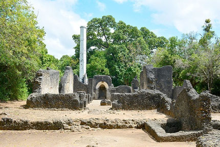
On a tall bluff near the ferry on the south side of Kilifi Creek, 35 miles north of Mombasa, are the remains of two mosques, the foundations of a third, and a group of tombs with carved coral decoration and Arabic inscriptions. The bluff is on a headland, between a steep gully and an inlet fringed with mangroves, now dry except at very high tides. Across the base of the headland was a boundary wall with a gate, enclosing an area of between 5 and 10 acres. Between wall and mosque is a well and the foundations of stone houses. In this vicinity a coin was found. The type is illustrated by Walker ? and is of Sulayman ibn Hassan, Sultan of Kilwa (1294-1308), who is credited by the Kilwa Chronicle with the conquest of most of the coast. The whole area, bluff, inlet, and high ground behind, has been known as Mnarani at least since 1884 when it was visited by Sir John Kirk. Mnarani must have formed part of the old “city state’ of Kilifi (the Quelife of the Portuguese) which would have included three townships, namely Mnarani, Kilifi, and Kioni, probably the site now known as Kitoka.‘ Kilifi is described by the Portuguese as a town ruled by a brother of the Sheikh of Mombasa, which is mentioned as joining in the general uprising against the Portuguese in 1585. In 1589, the Sheikh of Kilifi was killed in battle with the Wasegeju, the allies of the Sheikh of Malindi, and Kilifi became part of the new Sultanate of Malindi-Mombasa. In 1614 the Sultan Hassan ibn Ahmed, in the course of his quarrel with the Portuguese captain, Manuel de Mello Pereira, retired to Kilifi. According to local tradition, Kilifi was destroyed by the Galla, as were many other towns on the mainland, presumably in the first half of the seventeenth century. Kilifi appears on several eighteenth-century maps.
Taken from: Mnarani Ruins, more than an ancient story.
http://www.watamukenya.net/en/articles/news/last-news/mnarani-ruins-more-than-an-ancient-story.html
Mnarani was a Swahili settlement in the 14th century. At that time, traders from Oman used to sail with the monsoon winds from the Persian Gulf the Indian Ocean and land on the Kenya coast. Archaeological evidence shows that the site was eventually destroyed by the Galla in the early 17th century. In 1950, James Kirkman, a British archaeologist found several remnants, including 14 lamps.
Among the ruins are remains of a large Friday (or congregational) mosque, a smaller mosque, parts of the town, a gate and several tombs dating to the 15th century, when a reconstruction of the mosque was done after the collapse of the earlier building. The best-preserved ruin is the Great Mosque, with its finely carved inscription around the mihrab (prayer niche showing the direction of Mecca) with multiple arches and inscribed jambs. Interestingly, the inscriptions on the tombs and the mosques here are written in Persian language, suggesting that the early settlers in Mnarani were Persians from Oman. Only one tomb bears the name of Shaykh Isa Ibn Shayah Nahafah, a written in ancient Arabic. Under the minaret lies the skeleton of the supposed founder of the town. At the ruins also lies a dried up 75-foot deep well.
Note: written in Persian language is very unlikely as James S. Kirkman 1959 has extensively described these tombs. He mentions twice that it is Arabic text. And for most parts of the different tombs he mentions a closely resembling one from other Swahili places.
Taken from: Mnarani of Kilifi: The Mosques and Tombs by James Kirkman, Ars Orientalis Vol. 3 (1959).
Oldest Strat:
The single sherd of imported ware was the celadon from a class found in both the fourteenth century. The wound glass beads with “old gold” tint are a new find. The proportions of colors, viz, green, yellow, black, in the drawn beads, would suggest the middle of the fourteenth century.
Strata of the building first pre-mosque occupation level, then the building level of the Great Mosque.
The predominant Islamic ware was the yellow-and-black geometrical ware, which is characteristic of the fourteenth century but dies out in the early fifteenth. The sherd of the polychrome dish, with design in black and blue in a circle on the bottom over a hard pink body, is probably also fourteenth century. The Chinese wares included celadon and stoneware, ascribed preferably to the fourteenth century, and others to the fifteenth century. The local earthenware contained sherds of up to the end of the fourteenth century. The most interesting individual piece was the lamp. The carinated pots are equally common in fourteenth- and fifteenth-century levels. The bowl with a wide mouth and straight sides are fifteenth- rather than fourteenth-century classes. It is largely on their presence that the date of the Mosque rebuild has been advanced to 1425.
Upper Stratum: The sherds of local earthenware found at Gedi in fifteenth-century levels. The sherd pattern of the local and Islamic wares points unmistakably to the sixteenth century as the last period of Mnarani. The Chinese wares, on the other hand, the celadon, the white and blue-and-white, are of the fifteenth century, predominantly of the later fifteenth century. The two dishes of late sixteenth-century blue-and-white show that attention was still being paid to the site at the end of the century.
Taken from: THE MONUMENTAL ARCHITECTURE AND ARCHAEOLOGY OF THE CENTRAL AND SOUTHERN KENYA COAST by Thomas H. Wilson, Ph.D.
Kilifi
Kilifi is now, and probably was in the past, located on the north bank of the creek. The old settlement, of which there are now no structural remains, was probably in the area of the District Headquarters. A roadcut to the water's edge revealed potsherds to a depth of about a metre below the surface of the ground, so there was some sort of old settlement in the area. This is all we found, though.