Sofala
-------
Most of the early authors during the Middle Ages wrote about the land of Sofala. Only much later a certain place was called Sofala or Sufala or Cefala …..(Except for the Persian Hudud al Alam (982) where Sofala is the seat of the Zang King.)
The first three authors are:
-Yahya ibn Barmak; Kitab al- Majisti (The greatest book) (about 800) (Almagest, translated from Ptolemy).
-From Jahiz's Kitab al-Hayawan (Book on Animals) from Basra (869).
-Al-Mas'udi (916) Muruj al-Dhahab wa-Manadin al-Jawhar (Meadows of gold and mines of gems).
Note also: In the Kitab Ghara'ib al-funun wa-mulah al-'uyun (1050) a place is mentioned: ‘the bay of the amir’ this according to Horton, M. (2018) in ‘The Swahili Corridor Revisited’ may be Sofala bay.
Right: Sofala from Francois de Belleforest 1575.

Taken from: Africa Pilot: South and east coasts of Africa from Cape of Good Hope to Ras Hafun; United States. Hydrographic Office 1916.
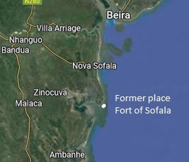
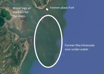
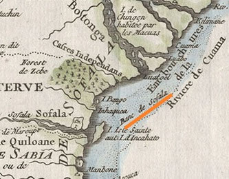
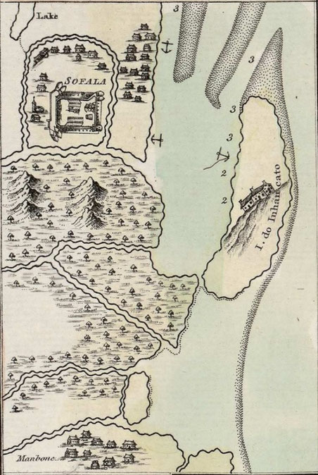
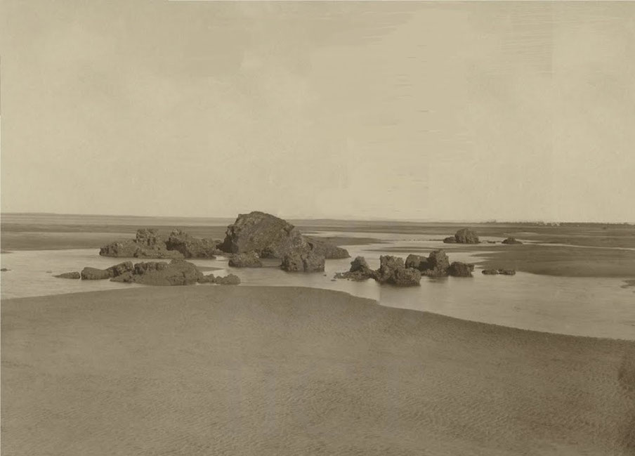
Sofala river, is 1.75 miles in width at its entrance, but this width is nearly filled by sand banks drying at low water. Ilha Inhancata, forming the south side of the entrance, and separated from the mainland by a boat channel, is nearly 2 miles in length in the north and south direction, while the northern point of entrance has on it the town and dilapidated fort of Sofala.
The town of Sofala, standing on the sandy peninsula on the northern side of the river entrance, has an estimated population of about 2000, and is the residence of a Portuguese governor; the fort build in 1505, was the first constructed by the Portuguese on the east Coast of Africa. The trade is insignificant, a small quantity of ivory, beeswax, and groundnuts being exported to Beira.
From Sofala river the coast trends in a northerly direction for nearly 20 miles, to the entrance of the Buzi river.
Ibn Majid says: until arriving, o accompanying, to the eminent Sulan (or Sulanyat), that is a reef above Sofala. And everything here is sand, my pilot!
Taken from: THE ARCHAEOLOGY OF THE SOFALA COAST by R. W. DICKINSON 1975
Before the caravels arrived, the gold traffic from the Karanga deposits inland was controlled at the coast by a group of Muslim traders ruled by Sheikh Yusuf, who had just declared his independence from his traditional suzerain in Kilwa. The Sofalan communities are described in contemporary Portuguese documents. All the folk were black, but two different societies lived side by side. Yusuf's Traders numbered around 800 (Alcagova 1506: 396). They were 'Moors' or Muslims, and dressed quite differently from the 'Caffres', or tribesmen, who lived in their thousands around the Muslim settlement. Muslims wore turbans, sashes, and silk or cotton robes, carried scimitars with gold-decorated ivory handles in their belts, and sat in council on three-legged stools with kaross-covered seats (Gois 1566). The local tribesmen who attacked the fort in 1506 under their leader, Moconde, were naked, fought with assegais, clubs, bows and arrows, including incendiary arrows (Castanheda 1551). They wore cotton garments, and their women loaded their legs with copper bangles and pierced their lips (Figueroa 1505-1511: 599). Fat-tailed sheep, cattle and poultry were kept at Sofala; rice, sugar-cane, coconuts, and millet, from which sadza was made, were the staple foodstuffs (Figueroa 1505-1511:595 & 599). Fish, oddly enough, is not mentioned in the earliest accounts, but later sixteenth-century writers repair this omission.
In one respect, Muslims and tribesmen were alike: both lived in thatched pole and daga huts (Barros 1552). The sheikh's house was long and narrow, capable of seating a hundred men, with a small audience apartment at the end (Castanheda 1551).
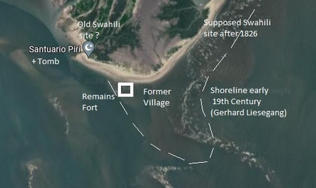
Yusuf's settlement lay half a league (between 2 and 3 km) from the village which stood just seaward of the fort. The fort, originally a log palisade, was later replaced in stone (Pereira 1507: 47; Almada 1516: 281). The present coast at this point has lost a strip of land up to half a kilometre wide by sea encroachment since Captain Owen published his survey (Owen 1833).
The Tomb at the extreme north-west, according to oral tradition (Dickinson 1968:46), contains the body of a Shafi saint who arrived in Sofala before the Portuguese. From the name which some give to the person buried there, it might be the grave of Sheikh Yusuf, killed by the Portuguese after the siege. The structures in the little cemetery have no inscriptions, and are no more than forty years old (Earthy 1931: 224), but the tradition is ancient. The area close to the Tomb fits well the location of Sheikh Yusuf's village as described in sixteenth-century accounts.
The brief excavations confirm what may have been suspected from early sixteenth-century documents but could not hitherto be stated positively: that the tribal African folk met by the Portuguese around A.D. 1500 were a branch of the Shona world of the monomotapan hegemony inland. (No settlements older than around AD 1500 were found till now in Sofala). They lived in pole and daga huts, like those of the modern rural Shona. They used iron implements and kept cattle. Meat, fish and shellfish were included in their diet, and spindle-whorls show the manufacture of thread as a local industry. Ornaments of bronze were worn and combs used. Cane-glass-bead patterns were predominantly yellow at Muringare and Indian red at Sofala, with accents of other colors.
Taken from: Archaeological Sites on the Bay of Sofala by Gerhard Liesegang.
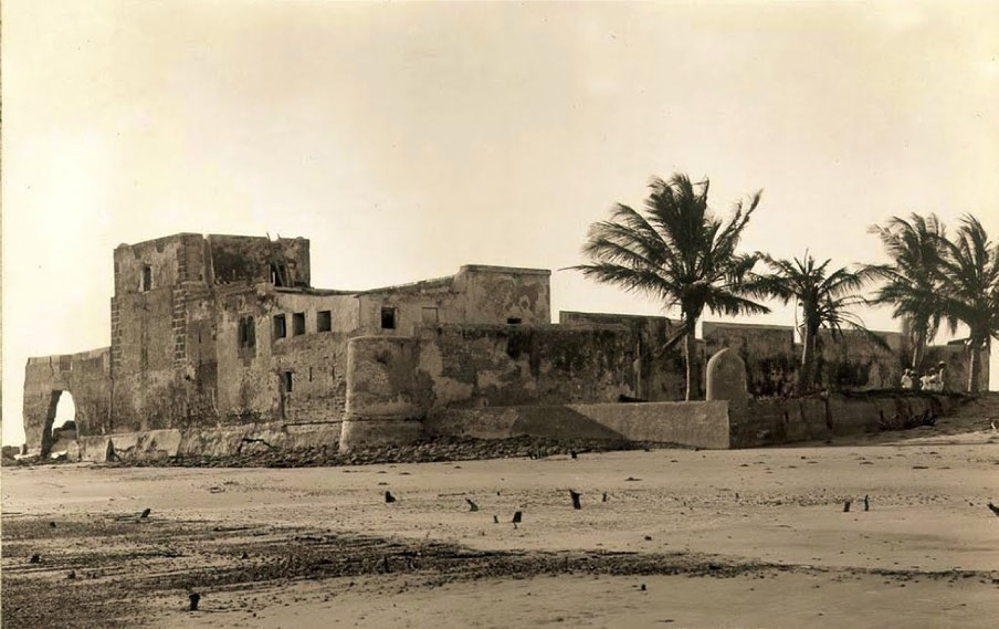
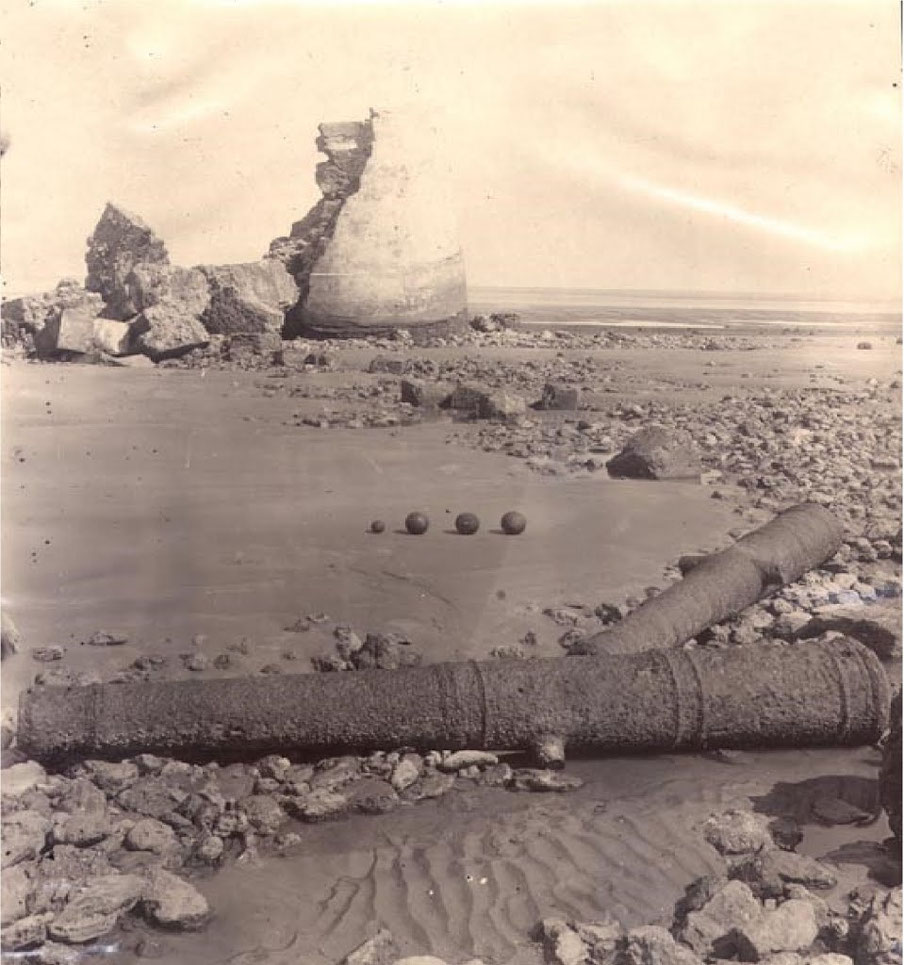
Due to the forces of erosion, the Portuguese fortress built at Sofala in the sixteenth century has nearly disappeared. Even less is left of the Portuguese settlement to the north of the fortress founded in the same period. But the existence and nature of this site is well documented through drawings, plans, descriptions, and photographs. The precise location of the pre-Portuguese Islamic settlement, whose age seems to be uncertain, has, however not yet been located.
The Question of the Pre-Portuguese Settlement:
Portuguese sources indicate that the first fortification built in 1505 by Anhaya was not constructed in the centre of an existing settlement, but rather between that of the head of the local Islamic community, "Cufe" [Yusufu], and another village. The former was located "half a league" (2 to 3 km) from the bar and the other near the bar itself (Axelson, pp. 82-3; G6is, II, p. 31; Lobato, 1954). It is likely that the site of the fort remained the same when it was rebuilt in stone.
The outstanding question is whether or not the site inhabited by the Muslims has disappeared. The following 1844 account of the area by an inhabitant of Sofala, Joao Juliao da Silva, raises the possibility that this site has not been washed away: There are three notable rivers of salt water which flow into the bay (from the north). The first is Inhaminagi [Nyaminaji] which is a quarter of a league away from the fortress. According to tradition and our histories the Arab King named Essufo [Yusufu] lived there before the arrival of the Portuguese ...
The "Inhaminagi river" must be the one which is called "Mwenye Mukulu" today. (The two others are the Ndungulu and Nyamakande . According to another manuscript by da Silva written in 1846 there were (unspecified) "vestiges" of the old settlement near the "'Inhaminagi". Today this creek is named after the Islamic saint whose tomb is close to it. Castilho's 1889 account was apparently the first reference to the tomb. The tomb itself must have undergone at least three modifications in the last fifty years. Dickinson collected two oral traditions concerning the name of the man associated with it. The custodian called him Saide Abdul Raman (Sayyid 'Abd aI-Rahman?), while other local inhabitants, whose knowledge may directly or indirectly derive from written sources, call him "Issufo [Yusufu]". This is the name of the head of the Islamic community killed in 1506 by the Portuguese (his name is also mentioned by J. J. da Silva (1844)). The question whether or not this tomb does in fact stand on his grave cannot be answered with the present scant knowledge.
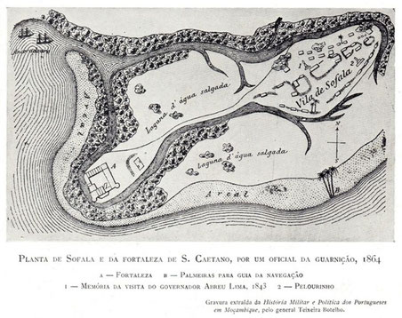
According to the chronicler Gois (1566 II, p. 31), the fort was at a distance of a crossbow shot from the "river" when it was founded. Between it and the bar there was still another village of "400 households (visinhos)". Today the ruins of the fort are partially covered with water when the tide comes in. But there existed a village inhabited by the Muslim population between the fortress and the open sea even in the early nineteenth century.
This map of 1864 shows no more Swahili village only the Portuguese settlement.
The end of the Sofala Fortress
Taken from : Sofala : d’un pôle commercial swahili d’envergure vers un site archéologique identifié ? Jules Frémeaux 2018
In this article he puts together what exactly Ibn Majid said about Sofala in his Sufaliyya.
Sufala
The Sufaliya does not give us much information about Sofala, as most of the text is about navigation. But the very fact that an entire treatise is dedicated to the routes to Sofala tells us something about its importance:
“If you reach the [Sufala] estuary at night, approach
And lower the sails until morning, you'll find the entrance
Marked on its perimeter by stakes.
The local fishermen will come to you,
You thus enter Sufala and be grateful.”
If Ibn Majid writes this poem, it is because trade flows must be important there and it meets a need. Ibn Majid produces and uses concrete knowledge, the information is always precise and beyond the poetic and religious framework the information of the whole poem does not seek to be symbolic, but practical. In the previous quotation, he tells us that Sofala is indicated by stakes.
“There, the landmarks are made of wooden stakes,
To the estuary, [placed] by someone seeking merits. »
In these two quotations, we are told that wooden stakes indicate the way. This device allows boats not to approach shoals and to indicate navigable channels. Ibn Majid gives descriptions for docking in many other commercial places and no other seems to have this kind of facility. This information could let us think that the port of Sofala is more organized than the average. In addition, the author often tells us that Sofala is clearly visible. For other cities, it indicates small landmarks to find your bearings. For Sofala, there does not seem to be a problem:
“And hasten to the entrance with the [customary] festivities
And go to the city near the entrance,
You will see it clearly. »
Politically, Ibn Majid gives us two seemingly contradictory informations.
“But Sufala is in Munamunawa
And the name of the king's seat is Zimbawa"
A little further on, he tells us:
“But Sufala, the port of gold,
Is under the domination of Kilwa, do not argue!
I mean the coast, O you who question me! »
Ibn Majid tells us that Sofala is under the domination of the Monomotapa Empire and the Sultanate of Kilwa. It is well integrated into the sphere of influence of Kilwa in the 12th century by Sultan Suleiman Hassan. But Sofala in fact keeps its autonomy and constitutes as the interface between the empire of Monomotapa and Kilwa. At the end of the 15th century, Sofala would have broken its ties with Kilwa on the occasion of a succession of the sultanate. Thus this inconsistency could be linked to an addition to the original copy linked to the new situation of Sofala. It is more likely, however, that the two quotes are not contradictory in the author's pen and that Sofala is indeed considered to be under the influence of both entities. Ibn Majid insists on the commercial interest of Sofala. As we can see in the previous quote, Sofala is often referred to as the port of gold, the provenance of which it even tells us.
[But] the gold mines, note my indication,
Over Sufala and the coast, oh my brother, to those mines,
The path is more than a month, know that well!
This statement is difficult to interpret. Arab merchants can easily have this information in Sofala, but without necessarily understanding where this place is located a month's walk away. It could be the plateau of Zimbabwe or Nubia. As we saw above, the distorted view of Africa leads them to believe that the Zimbabwe plateau and Nubia are neighbors:
“[Live] at the Kwama estuary, I have it from information.
This estuary [penetrates] far [inland] and its origin
Is in the land of the Nile of Egypt, where it separates.
The inhabitants [of the country] between Sufala
And Kajalwa are evil infidels;
They are called Muna, from the name of a great king,
Muna Batur, and what an infidel he is!
He has a mine like that of as-Sufal
Because his country immediately follows him in the East.
From the east of Sufala you can see
The kingdom of the infidels, upon it be aversion!
It reigns from the "Estuaries" to Zanzibar
On land and sea, as he wills,
And he owns gold mines,
For they are in the land of the infidels
With its rude and vile inhabitants,
And the Nubia mine is next to them.
They have relationships with each other,
A river separates them. The ends of their land »
For Ibn Majid and the geographers of the time, the "ends of the earth" meet and the three rivers, the Zambezi called Kwama in this quote, and the white and blue Nile are the junction. Thus, as we have seen, in the Ptolemaic geography which the Arab geographers inherited, the African continent bends to the East to close the Indian Ocean. Who is Muna Batur and what is his kingdom? We have no idea about it, but we can think that it is not about Monomotapa, quoted in other places under the name of Munamunawa. Moreover, Ibn Majid knows that it comes from gold and slaves:
Who [Monomotapa] is a mine of men, know it well,
And which is the country of the slave traders, oh my dear!
Ibn Majid does not tell us of amber or ivory in Sofala, but gold and slaves are described there as very abundant. Last interesting point in the description of Ibn Majid, the surroundings of Sofala, whether in the North or in the South, are described as inhabited by vile and dangerous infidels.
Because it is an exposed coast, believe me!
She throws you towards Kwama of the infidels,
Because of this, recognize [the land] in broad daylight
And if necessary, reduce the canvas
Until morning and be vigilant!
According to Ibn Majid, the only Islamized town south of Kilwa is Sofala. We can think that this consideration is not really religious or moral, but that the idea of Islamization here corresponds to inclusion in a commercial network. The “Muslims” are first of all the more or less Islamized regular merchants. Thus Sofala may indeed be the only commercial town south of Kilwa. The author is very virulent with these populations that he considers dangerous. Is it an agreed aversion against “infidels” or societies excluded from exchanges that can play a parasitic role, through piracy for example?
Many cities are shrouded in fantasy and myth, especially when it comes to gold. This text does not give us a precise description of the city, but it describes Sofala, a city integrated into the Swahili world and the main port of gold, in a pragmatic approach to the trade routes of the Indian Ocean, thus giving real consistency to this historical but disappeared object.
End of the Middle-Ages View of Sofala by the Portuguese.
Note the following words:
Leagues: 5.5km
Mithqal/miticals: 4.25gr of gold
Almadias A small African canoe made of the bark of trees
Zambuk: Sambuk; is a type of dhow, a traditional wooden sailing vessel.
Taken from: Da Ásia de João de Barros, dos feitos que os Portuguezes fizeram no descubrimento e conquista dos mares e terras do Oriente ; João de Barros 1552. (first decade)
(In 1498 when the ships of Vasco da Gama start leaking). Because of fear they sailed so fast, that he passed without seeing the town of Cofala, so celebrated in those parts because of the much gold that the Moors had taken from the Negroes of the land via trade,……
Taken from: The first Booke of the Historie of the Discoverie and Conquest of the East Indias by the Portingals, in the time of King Don John, the second of that name. By Hernan Lopes de Castaneda. Translated into English by Nicholas Lichefield 1582.
(Voyage of Pedro Alvarez Cabral to India in 1500)
(The King) He therefore commanded that a fleet of ten ships and two caravels should be got ready against next year, to be well laden with all the commodities which De Gama had reported to have current sale in Calicut. There went others also to Sofala and Quiloa, where also he commanded factories to be established, both on account of the gold which was to be found there, and that the ships might have a place to touch and refresh at in their way to and from India. …………… Two ships were to remain with the merchandise at Sofala, where Loriso Hurtado was to be factor. ……
…… Proceeding in this manner, the general came to Sofala, with which the pilots were unacquainted, near which lay two islands, [Named Inhazato] close by one of which two vessels lay at anchor. These immediately made for the shore on seeing the Portuguese ships, and being pursued were taken without resistance. The principal person belonging to these vessels was a near relation [According to De Faria, this person was uncle to the king of Melinda, and was named Sheikh Foteyma] of the king of Melinda, and was going from Sofala to Melinda with gold. The people were so much afraid on seeing our ships, that they threw a great part of the gold into the sea, and most of them escaped on shore. The general was much concerned at his loss, especially that it should have fallen on the subject and relation of a prince who was in friendship with the king his master; and after shewing him every civility, restored the two vessels with all the remaining gold. The Moor asked Cabral if he had any witches on board, who could conjure up his gold from the bottom of the sea? Cabral answered, that the Christians believe in the true God, and do not practice or give credit to witchcraft.
Learning from this Moor that he had overshot Sofala, and not being inclined to turn back, the general continued his voyage to Mozambique; where he arrived on the 20th of July and took in a supply of water, and procured a pilot to carry him to the island of Quiloa, ……
(On the return voyage Cabral sends Sancho de Toar with a ship to discover Sofala)
…… Back in Lisbon Sancho de Toar arrived from Sofala. He described Sofala as a small island close on the continent of Africa, inhabited by a black people called Caffres; and reported that much gold is brought to this place from certain mines on the adjacent continent; on which account Sofala is much frequented by Moors from India, who barter merchandise of small value for gold. He brought along with him to Lisbon a Moor whom he had received as an hostage or pledge for the safety of one of his own men, whom he had left there to acquire a knowledge of the country and its language; and from this Moor they got ample information respecting the people and trade of those parts of Africa, ……
Taken from: Three Voyages of Vasco da Gama, and his Viceroyalty. From the Lendas da India of Gaspar Correa (1492-1563); accompanied by original documents. Transl Stanley.
(Second voyage of Vasco da Gama 1502)
(Pero Affonso makes a deal in Sofala)
……… and that he (the King) would buy as much merchandise as they brought, and would give for it what he gave to the other merchants, which was a price that had been a long time established. As a pledge of the truth of this, he took off from his thumb a gold ring and gave it to Pero Affonso, and then gave as a present to the captain-major a bundle of strings of small gold beads which they call pingo, and which weighed a thousand mithkals, and each mithkal is worth five hundred reis (small copper coin); and he gave another for the King which weighed three thousand mithkals, and one to Pero Afonso of five hundred mithkals, and he said that he gave that to the King of Portugal as a sign of everlasting brotherhood as long as they complied with it also towards him and did no harm to his trade and merchants nor to his country. ……
…… The next day Pero Afonso returned to the King, saying that he would be glad to buy and sell things, at which the King was pleased, and told him to order what he had to be brought and it should be sold at once. Then they brought everything before the King, who ordered the merchants of the country to come there, and they separated the goods, each kind by itself, and having counted it all, they weighed gold in small scales, and upon each kind of cloth they placed its price, in the gold which each one was worth. Then the King said that those stuffs were worth the gold which was on the top of them, and that they might take it, and he said that his dues were already accounted for in the weighing, as the merchants paid them. ……
Taken from: A description of the coasts of East Africa and Malabar, in the beginning of the sixteenth century. Duarte Barbosa 1514. Transl Stanley.
SOFALA.
Having passed the Little Vciques, for the Indies, at XVIII leagues from them there is a river which is not very large, whereon is a town of the Moors called Sofala, close to which town the King of Portugal has a fort. These Moors established themselves there a long time ago on account of the great trade in gold which they carry on with the Gentiles of the mainland: these speak somewhat of bad Arabic (garabia), and have got a king over them, who is at present subject to the King of Portugal. And the mode of their trade is that they come by sea in small barks which they call zambucs (is a type of dhow, a traditional wooden sailing vessel), from the kingdoms of Quiloa, and Mombaza, and Melindi; and they bring much cotton cloth of many colours, and white and blue, and some of silk; and grey and red, and yellow beads, which come to the said kingdoms in other larger ships from the great kingdom of Cambay, which merchandise these Moors buy and collect from other Moors who bring them there, and they pay for them in gold by weight, and for a price which satisfies them; and the said Moors keep them and sell these cloths to the Gentiles of the kingdom of Benamatapa who come there laden with gold, which gold they give in exchange for the before mentioned cloths with-out weighing, and so much in quantity that these Moors usually gain one hundred for one. They also collect a large quantity of ivory, which is found all round Sofala, which they likewise sell in the great kingdom of Cambay at five or six ducats the hundred weight, and so also some amber, which these Moors of Sofala bring them from the Vciques. They are black men, and men of colour — some speak Arabic, and the rest make use of the language of the Gentiles of the country. They wrap themselves from the waist downwards with cloths of cotton and silk, and they wear other silk cloths above named, such as cloaks and wraps for the head, and some of them wear hoods of scarlet, and of other colored woolen stuffs and camelets (made of camel’s hair), and of other silks. And their victuals are millet, and rice, and meat, and fish. In this river near to the sea there are many sea horses, which go in the sea, and come out on land at times to feed. These have teeth like small elephants, and it is better ivory than that of the elephant, and whiter and harder, and of greater durability of color. In the country all round Sofala there are many elephants, which are very large and wild, and the people of the country do not know how to tame them: there are also many lions, ounces, mountain panthers, wild asses, and many other animals. It is a country of plains and mountains, and well watered. The Moors have now recently begun to produce much fine cotton in this country, and they weave it into white stuff because they do not know how to dye it, or because they have not got any colors; and they take the blue or colored stuffs of Cambay and unravel them, and again weave the threads with their white thread, and in this manner, they make colored stuffs, by means of which they get much gold.
Taken from: Friar João dos Santos (1622) Ethiopia Oriental (Vária historia de cousas notaveis do Oriente), Lisbon, 1891-2
(The facts mentioned date from 1573-1580 AD)(4)
The curve, or tribute, that the Portuguese and Kafirs pay to Quiteve (1) and how it is collected.
It is already said in the previous chapter, that the captain of Sofala paid tribute to the Quiteve king of those lands, two hundred cloths each year for granting him the land. These two hundred cloths are worth in Sofala more than a hundred cruzados (3), and this among the Portuguese, but among the Kafirs they are worth more than a hundred thousand reis (2). The Kafirs call this tribute curve, which Quiteve orders to collect and collect every year in Sofala in the following way: He sends four ambassadors, whom he elects for this purpose, …… (description of the task of each ambassador being collecting intelligence and tribute) ……
The captain (Portuguese captain of Sofala) gives all these kafirs lots of cloths and bills, with which they are satisfied and happy, and this is beyond the tribute that goes to Quiteve, which gifts are the interests of your embassy; and Quiteve dispatches them with similar offices, for giving him a lot of mercy and honor and giving them this opportunity to gain the interest and gifts that the captain gives them.
When these ambassadors come to get this tribute, they bring with them more than a hundred kafirs, so to accompany them, as to carry the clothes and beads on their backs, as is your custom.
And before they reach the town of Sofala, at about half a league a little more or less, send a message to the captain, of how they have already arrived and soon the captain orders them to be received by the Sheikh of Sofala, who is Moorish (Here meaning Swahili), with some other Moors, to come with the Kafirs to the fortress; who enter the village all together in the following way.
…… (description of the festive and official procession) ……
The captain of the fortress awaits them and receives them with great courtesy, in a room of the fortress, where he is accompanied by all the Portuguese he rules, and from there he orders them to present themselves in the place of the Moors, where
they are provided with everything necessary for their
stay, which are seven, or eight days. (5)
The Portuguese traders who go with their merchandise to Manica on passing through the lands of Quiteve pay a tribute or duty to the said Quiteve of one piece of cloth in twenty, and the same for beads; and thus they pass in safety through his lands to the kingdom of Manica, where the gold mines are.
(1) Quiteve: (According to professor Fran Pritchett) Empire of Monomotapa; in process of time this great empire was divided into three kingdoms, called Quiteve, Sabanda, and Chicanga but all remain under the emperor of Monomotapa.
Quiteve is that kingdom or province of Mocaranga, now named Sofala from the river of that name by which it is pervaded. The kingdom lasted till the late 19th century. The commercial station of Sofala belonging to the Portuguese is at the mouth of the river; and about 220 miles from the sea is a town called Zimbao of Quiteve. This Zimbao of Quiteve is to be carefully distinguished from a town of the same name in Monomotapa. The former is nearly in lat. 20° S. on the river of Sofala, the latter is about 16° 20' S. near the river Zambezi or Cuama.
(2) reis: Portuguese coin. From the reign of King Manuel I (1495–1521), the name was simplified to real, coinciding with the switch to minting real coins from copper.
(3) cruzado: here Portuguese coin made from African gold.
(4) In 1573 the agreement to pay tribute to Quiteve was made.
(5) Caravans entering Sofala from the interior were greeted by the sultan; yet it was the local merchants who entertained caravan leaders, granted them accommodation, and carried out the business of exchange. This is a way of trading different from what Ibn Battuta described in Mogadishu in 1330.
Taken from: Records of South-Eastern Africa: collected in various libraries and archive departments in Europe by Theal, George McCall, d1919. Vol 2
EXTRACTOS DO LIVED CHAMADO LENDAS DA INDIA, FOR GASPAR CORREA. d1562
Pedro Alvares Cabral. 1501.
P26
Sancho de Toar took also for the king (of Sofala) a present of pieces of crimson silk, mirrors, caps, trappings for hawks, little bells from Flanders, small transparent glass beads, and other things to be had in that country, and which delight the people of Sofala.
Dom Francisco d' Almeida, Viceroy. 1505.
P34
Then he (Dom Francisco d' Almeida in 1505), with all the captains dressed in their best, …… went with fifty armed men and trumpets before him to the place where the king (of Sofala) was, followed by a multitude of people. The houses were surrounded with very strong hedges of thorns, with closed doors.
They entered a large house built of earth, all the rest being of straw, and in this large house were many Moorish merchants well dressed. The king was in a small house apart from this, which was ornamented with coloured silk hangings of Cambaya. He was lying upon a couch, as he was very old and blind, and he showed great pleasure at the arrival of our people. He ordered the chief captain to sit down on some very handsome mats near his couch, and the rest of the people remained standing before the house.
Taken from: Documentos Sobre Os Portugueses Em Mocambique E Na Africa Central 1497-1840 Vol III
STATMENT BY PERO SOBRINHO AND DIOGO HOMEM, CLERKS OF THE FACTORY OF SOFALA
Sofala, 1512 April 15
Regarding the death of Maulide, king of Sofala, and the appointment of a successor,
P245
(The Portuguese had gone to kill the King of Sofala who had fled to the mainland.)
And when they returned from Pandene (on the mainland) all the Moors carne to the fortress very pleased with what had happened, because they had not dared to leave Sofala and go to the mainland, being afraid and now it seemed that they could go out and earn their living as they had done before the king had gone to Pandene.
And on the following day the factor summoned all the most honoured Moorish merchants who were in Sofala and 'they all came to the chamber of the fortress; and he spoke to them telling them that king Maulyde was dead and that they had killed him for the evil he had done them which, as they knew, is what the king did whenever he could.
They answered that it was true that no good man could die the death the king had died, but only men like him who endangered the land.
And the factor told them that they had no King in Sofala and that it was not good to he without a governor, so let them agree between themselves to elect the Moor whom they thought most suited, with a good head, to he their sheik and govern them with kingly power, but that he would only hold the title of sheik; and let them now go to Sofala and, on the following day, bring him to the fortress to see the sort of man he was and to elect him sheik.
Item, on the 9th day of the said month of September of the said year all the greater and lesser Moors came to the fortress bringing a Moorish youth, whom they call Quyunbe, heir of the land, son of a brother of King Maholyde, whom they had killed and they said that this was the man they had brought to be made sheik and to govern Sofala, and that all of them were very happy to have him, and that if any one present was dissatisfied let him speak.