
Sindjadi or Bandar Darwis (The Quirimba Islands)
---------------------------------------------------
Ibn Majid (1470) is the only author who mentions the place in his Sufaliyya. However, in the Kitab Ghara'ib al-funun wa-mulah al-'uyun (1050) a place is mentioned: Island of ⟨. . .⟩d-l-h this according to Horton, M. (2018) in ‘The Swahili Corridor Revisited’ may be one of the Kerimba islands. Ibn Majid in his Hawiya calls the place Bandar Darwis. That this is the same place is made clear in this passage: Seydi Ali Reis (d. 1562) in al-Muhit: at 9 fingers ………. Bimaruh on the east coast of Komr; Anamil on the west coast of Komr; Sindjadjï on the Zanj coast, called by some Bandar Darwis. Darwis = a religious mendicant.
Note: with Bandar Darwis at 12.4°S; Anamil at 15.8°S; Manzalagi at 15.2°S and Bimaruh at 13.3°S we can see how problematic the description ‘at 9 fingers’ is.
Taken from: Northwards from Sofala: Archaeological Reconnaissance in Cabo Delgado Province, Northern Mozambique by Nathan Anderson.
Ibo Island
The collection of artifacts from excavations on Ibo detailed in Stephens 2006; Torres, et al. 2016: 59 was found in the corner of a dark room in Fortaleza Sao Joao Baptista. The bags and information tags had almost completely deteriorated leaving a context-less jumble. The artifacts within the fort were those recovered during Stephens’ excavations near Fortaleza Sao Joao Baptista and the Ibo chapel in 2006 and 2007. Only the identification of the decorated sherds of both 13th -15th centuries and 17th-19th centuries typologies, as they are described in Sinclair 1985, were identified within the jumbled assemblage.
Taken from: The Quirimbas Islands Project (Cabo Delgado, Mozambique): Report of the 2015 Campaign by Jorge de Torres Rodriguez.
The first archaeological research in Ibo took place in 1978, when Tereza Cruz and Paul Sinclair surveyed the island and excavated at three different sites, documenting two different occupation periods of 1150-1300 and 17th to 19th according to the archaeological materials (Sinclair 1987: 24). All of the sites were documented in the central area of the village of Ibo.
Around the hole (of a removed tree in the village square on Ibo) a high number of pottery—both local and imported wares—and glass fragments and beads were collected, with some examples with decorations similar to those of the so-called 13th to 15th centuries AD and 17th to 19th centuries AD traditions, which represent the Swahili culture in the region (Madiquida 2007: 63). The imported wares include some examples from China, dated to the Ming dynasty (15th to 17th centuries AD).
Taken from: Quirimbas islands (Northern Mozambique) and the Swahili gold trade by Marisa Ruiz-Galvez et al. 2021
(The same village square as above) yielded a remarkable amount of archaeological materials, most of them handmade pottery shards but also bones, shells, glass and different types of glass and shell beads and bead polishers, in addition to a carnelian and a gold bead. Imported materials, other than beads, were scarce but significant. Another test pit was opened some 150 m away from Ibo square, opposite to the Portuguese fort of Sao Jose and near to a previous trial trench opened by Stephens in 2015 (Stephens, 2006). Where we came across a Swahili dwelling area with Middle Eastern imported ware, imported glass beads and three bronze coins, dating between mid-11th and mid-13th centuries CE (Ruiz-Galvez et al., 2017; Ruiz-Galvez, 2020).
The central area of the square, lower levels only delivered local impressed ware, excepting one Middle East imported wheel-made shard dated between the 11th and 13th centuries CE Two dating samples from these levels around 1072–1227 CE confirmed the dating: (Ruiz- Galvez, 2020; García-Heras et al., 2021)
There is remarkable similarity between our bead and a common type of gold bead found at the cemetery of Mapungubwe Hill, the site south of the Limpopo River, where the ruling class was buried during the Iron Age (Oddy, 1984; Grigorova et al., 1998). Together with other gold items found as grave goods, they are considered the oldest gold work in southern Africa. Traditionally it was thought that the beads were not manufactured at the site but traded from Great Zimbabwe or Dhlodhlo (Oddy, 1984: 78). Mapungubwe and Great Zimbabwe were important trading towns in contact with North Africa, the Middle East, India and China via the Indian Ocean.
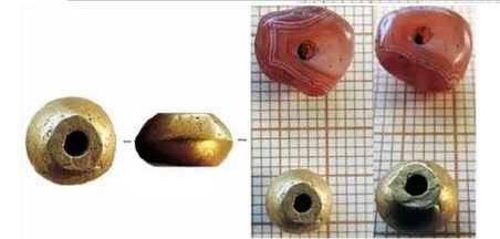
The so-called Sofala gold described by the traveler Al-Masudi actually came from the gold belts of the Zimbabwean plateau, Sofala being just its outlet. Wherever the Land of Sofala might have been, Huffman (2009:50) locates it in the first instance on the Barazuto Island in Central Mozambique, where Sinclair attested a mid-First Millennium CE occupation (Ekblom & Sinclair, 2018:179), and not far from the Chibuene coastal site with evidence of metal pro-duction such as gold droplets preserved in a crucible during its earlier occupation dated between 700 and 1000 CE (Ekblom & Sinclair, 2018: 178). Later on, Sofala could have been moved to its actual location at Beira Bay (central Mozambique), after the decline of Chibuene as a significant port in the mid-10th century (Huffman, 2009: 50). By the moment we must be cautious owing to the single AMS date for the context of the Ibo gold and carnelian beads, but we can be sure that the Ibo gold came from the Zimbabwean plateau and, probably, previously to the emergence of the Mapunguwe state. The find of these beads suggest that the Quirimbas had a role to play in the gold trade from Sofala to Kilwa and other Swahili cities, perhaps as a port of call from the expansion of the Swahili trade at the early Second Millennium BC.
Matemo Island
Taken from: Northwards from Sofala: Archaeological Reconnaissance in Cabo Delgado Province, Northern Mozambique by Nathan Anderson
The Swahili cemetery is composed of two partially collapsed rectangular tombs constructed of coral-and-lime in the coastal tradition. The decayed state of the tombs, paired with Portuguese accounts detailing the 16th century destruction of the Swahili settlement on Matemo make it likely that these structures were constructed as early as the late 15th century, and no later than the 16th (Madiquida 2007: 63; Torres, et al. 2016: 58). Neither tomb possesses a pillar, more commonly found along northern parts of the East African coast (Garlake 2002: 167; Gensheimer 2012: 109). The mosque appeared to be of a mid-second millennium Swahili architectural tradition. This structure was first detailed in Torres, et al. 2016. Based on the structural description provided in the 2016 report, the mosque has an internal area of 13m x 9.5m, was constructed of coral-and-lime with porites coral accents, had plastered internal surfaces, and still possessed an intact mihrab and minbar, clearly shown within figures in Torres, et al. 2016 (Torres, et al. 2016: 62).
Taken from: The Quirimbas Islands Project (Cabo Delgado, Mozambique): Report of the 2015 Campaign by Jorge de Torres Rodríguez.
In his description of Mozambique written in 1592, Joao dos Santos makes reference to a large Swahili settlement in the island, with many houses with their windows and doors decorated with columns (Santos 1891: 274), that was destroyed by the Portuguese during the conquest of the archipelago. The mosque documented by Hilario Madiquida in 1997 undoubtedly corresponds to this important site. The materials found in Ibo and Matemo seem to be showing an occupation that could be as old as the 12th century AD.
Quirimba island
One of the earliest documents of the Portuguese that referred to the archipelago, a punishment expedition which was carried out in 1523 against this Swahili settlement (Castro 1969: 175). This document describes a big village with hundreds of inhabitants and a factory house where there were kept several small cannons, gunpowder and many muskets, as well as ivory and other goods.
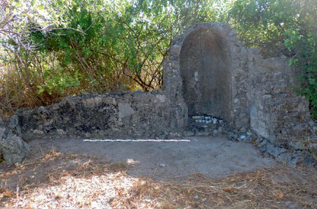
A Swahili site was located on the southwest part of the island. Although the dense vegetation prevented a systematic survey of the area, at least one squared building was documented. Near this building two other stone structures were located: a small (1.10m in diameter), circular structure that is difficult to interpret and a rectangular tomb.