
Charbuh or Sadbuwah islands (Chibuene)
-------------------------------------------------
Ibn Majid has them all at three fingers in his Sufaliyya. These islands include:
- Vacika or Wasika (Bazaruto islands)
- Vaza or Wazah (Inhaca island)
Satawah / Satuvah Ibn Majid has this place at five fingers in his Sufaliyya. JOUANNES Claude sees them as two different places; I see them as one place. There is also another possible identification for them: The Sabi or Save river (only because similarity of the name) but the latitude is way of: nearly 6 fingers.
Mulbaiuni city at a bid less than 5 fingers.
Ibn Majid in his Hawija has also: Rufati at 5 fingers.
All these places being at 5 fingers of Nach means around the Bazarutu islands with also there on the mainland the very important site of Chibuene.
I will try to give the reasons why to put Charbuh or Sadbuwah and Vacika or Wasika (at 3 fingers) also at or around the Bazaruto islands (at 5 fingers).
And Vaza or Wazah (Inhaca Island) will be handled under separately.
That so many places (or the same places with different names) have wound up at 5 fingers of Nach is normal the place is very old and has direct connections to Zimbabwe in the hinterland.
Ibn Majid is the only Author to mention all these places.
Idrisi (1150) and Ibn Said (1250) also mention Charbuh island but put it far too much north.
An uncertain mention in the Hudud al Alam (982): as southern town of Sofala
they give:HWFL; the town which in this country is by far the richest in goods (bisyar-khwastatarin). This, according to me, seeing the early date can not be anything else than
Chibuene.
In the Kitab Ghara'ib al-funun wa-mulah al-'uyun (1050) a place is mentioned: ‘Susmar (Crocodile), an island’ this according to Horton, M. (2018) in ‘The Swahili Corridor Revisited’ is intriguing, and may refer to the Bazaruto archipelago to the east of Vilanculos, and today protected by a national park, noted for its lagoons supporting significant crocodile populations. Adjacent to these islands is the eighth – tenth century trading site of Chibuene, and the terminus of the route into the southern Africa interior.
Taken from: Studia; Revista Semestral, Issue 32 1971 Centro de Estudos Históricos Ultramarinos (Portugal) Barradas, Lereno 1971 Roteiro de Sofala
The Poem of Vaza (Sufaliyya from Folia 93v line 25 till Folio 94r line 6)
The ports in this poem are: Kilvani, The Port for all Winds, Mulbaiune, Satuvah, vazica, Malabati, Vaza.
As for the geographical description, we found the text full of inaccuracies. Thus: Mentions Kilvani, but does not indicate his cosmographic position (R. 93 v, 25). He then names «Port to all winds», but does not give its name (R. 93v, 29). It presents Mulbaiune, but without exact details, geographical physical or cosmographic, which leads us to great indecisions for its identification (R. 93v, 31), since it already had another port with the same name, identifying it with Mozambique, which, however, also seems not to be right. Malabati must correspond to Inhambane, but its coordinates, for this purpose, are so inaccurate that we have to admit a large deviation. (R. 93 v, 32). Mention later the Charbuh Islands, of which Vazika is a part, which must correspond, as has been said, to one of the Bocicas, naturally Bazaruto, however, the discrepancies are so many that they give certain doubts and difficult explanation (R. 93v, 34). Then comes finally Vaza Island, whose perfect geographical description and cosmographic accuracy, lead to the identification safe, with Inhaca (R. 94r, 4).
This accumulation of inaccuracies, sometimes important, leads to the hypothesis that Ibn-Madjid did not travel south of Sofala, and therefore has not composed the Vaza poem, unless he was incorrectly informed from other pilots. It is possible that this poem was already known in the time of Ibn-Madjid, but very little used because as it seems, the trip seems unprofitable.
Charbuh or Sadbuwah islands (Bazaruto islands) (and all the other places at 5 fingers)
Al-Idrisi (1099–1166) noted that Sofala incorporated several towns, including Sayuna, which was “medium in size and its inhabitants are a collection of people from Hind [India], Zunuj and others….”. It is not suggested here that Sayuna should be equated with Chibuene, as it was probably located further north, but it is not unreasonable to suspect that most active ports along the southern coast would have had similar populations that were principally African intertwined with individuals from distant shores.
Note: The Umda of Suleiman (he has: Sarbuwa or Saryah at 3 fingers G.B.) adds here that it is really the end of the coast to the South.
Taken from: East Africa and the Orient p 141-142
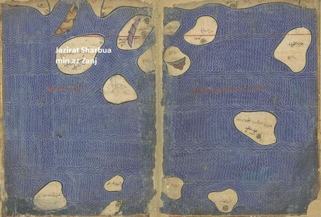
Jazirat Sharbua/ Sharbuwa/ Sharbada/ Saranda min az-Zanj. (island on map of Idrisi) This has naturally been taken to be Sarbuya = Sribuza= Palamban, but there is a possibility that there was actually an East African Saryua/Sharbua, as mentioned by Sulaiman al Mahri much later. On the map the island is situated right off Mount Naked (Jabal Ajrad) between al-Banas and Bat-hana. See Al Umdat al-Mahriyya in Ferrand Instructions Nautiques, II folio 20v where he has (Sarnua) and 30r (Jazirat Saryua and Sharbua).
The islands of Cotria, El-Qeroud, Kermouah, Beukan, Serira and Anfoudja found in Ibn Said’s work (1250) are the places: Cotroba, El-Qeroud (island of Monkeys), Kermedet (Kahua or Karmaba), the unnamed island (has Volcano; Grande Comoro), Cherboua (Sribuza or Sharbua) and El-Andjebeh ( Andjuba or Anjouan) of Al Idrisi (1150). (on this see: Documents sur l'histoire, la géographie et le commerce de l'Afrique ... By Charles GUILLAIN p 271)
On three of these islands: Kermedet (Kahua or Karmaba), the unnamed island (has Volcano), and El-Andjebeh ( Andjuba ) Gill Shepherd (The Making of the Swahili: A View From the Southern End Paideuma, 1982) has the following to say: These islands are according to Idrisi opposite the Zanj coast and depend (economically) upon the Indies. These are clearly identifiable as the Comoros, being Nzwani (Anjouan, = Andjuba), Ngazija (Grande Comoro, = has Volcano) and Maore (Mayotte, = Kahua or Karmaba). They are described as neighbours. (she then gives their distances to the Zanj places as prove). Not Gil Shepherd but others have since said: Cherboua (Sribuza or Sharbua) might be Moheli (the fourth Comoros island).
What Gil Shepherd says exactly is: Sharbua (or Saranda) is unidentifiable. It is described as a vast island trading pearls, aromatics and perfumes and-given that Madagascar is Komr – cannot be in East Africa.
The Book of Duarte Barbosa (1516) however says there is ambergris and pearls and Muslims who trade in them in the Great Hucicas (Vacika). And Ibn Majid says the group of islands is called Charbuh or Sadbuwah islands (Bazaruto islands) consisting of Vacika or Wasika, Vaza or Wazah, and third island?
My idea is that the Sharbua of Idrisi (1150) is the Charbuh of Ibn Majid (1470). And that it does also include the two settlements of Chibuene on the mainland.
The fact that Idrisi (1150) mixes them up with other islands further north must come from the fact that around the year 1000 Chibuene had become non-active in international trade, so his knowledge of the place is very vague. The same happens when he speaks about Cabala (Quanbala on Pemba Island but he places it close to Socotra). Qanbalu is another place becoming non-active in international trade around the year 1000.
Note: another identification of the Sharbua of Idrisi is Sribuza (present day Brunei in South East Asia.)

Taken from: The Archaeology of Africa: Food, Metals and Towns edited by Bassey Andah, Alex Okpoko, Thurstan Shaw, Paul Sinclair 2014
Two occupation levels are clearly visible in the stratigraphy and a third level may exist. The lower occupation at Chibuene has been dated to the later first millennium AD, contemporary with Kilwa Ib-level on the basis of ceramics (Chittick 1974), and a series of radiocarbon dates are all within the first millennium AD. The possibility that the basal levels reflect a mid or perhaps even early first-millennium, pre-Islamic occupation of the site has been strongly enhanced by the identification by H. Wright (pers. comm.) of a fragment of imported green glazed ware known from Sohar on the Omani coast. In east Africa, wares associated with the green glazed ceramics at Sohar are known only from Ras Hafun in northern Somalia and are dated there from the first century BC to the fifth century AD. Some very friable contemporary earthenware has been identified at Chibuene and similarly decorated material, dated to around the seventh century AD, has been recovered from the hinterland at Nhachengue. Some attributes of later earthenwares at Chibuene, found in association with Sassanian Islamic and tin glazed wares, are similar to the Gokomere/Ziwa tradition, which is very clearly represented at Dundo on Bazaruto island in association with blue-green glazed Sassanian Islamic sherds. Further south near Inhambane a site found by Adamowicz (pers. comm.) with earthenwares similar to those at Chibuene but without any imports, has been dated to the eighth century (Sinclair 1991).
The uppermost occupation at Chibuene is dated by four readings from the thirteenth century AD to the present and is therefore at least partially contemporary with Manyikeni and the Zimbabwe tradition. The ceramics from Chibuene show definite similarities with those of Manyikeni and other sites on the islands of the Bazaruto archipelago (Sinclair 1987, pp. 86-91) and also with the coastal wares known from the Save river mouth (Barradas 1961; Dickinson 1975), Sofala (Liesegang 1975) and the northern Mozambique coast at Sancul and Ibo Island Upper (Sinclair 1985; Sinclair 1986).
The trading site of Chibuene, occupied from at least the mid-first millennium AD, is of crucial importance for our understanding of the articulation of the offshore islands of the Comores, the southern extension of the east African coast and the southern African interior. Developments of the very substantial urban settlements at Mapungubwe and Great Zimbabwe from the late first millennium AD were preceded by the development, around the edges of the Limpopo basin, of extensive settlement hierarchies based on agro-pastoralism, with evidence for intensive metallurgical production (Sinclair 1987). Accompanying these developments was the penetration as far as the edges of the Kalahari desert (Kivaea-Mulindwa) of exotic trade goods in the form of glass beats identical to those found in Chibuene.
Taken from: Chibuene by Anneli Ekblom and Paul Sinclair in The Swahili World 2018
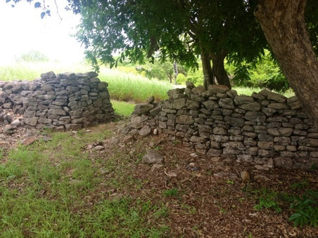
Hardly any evidence of constructions were found.
After c. 950–1000 CE, Chibuene lost its role as a hub of trade; glass beads and trade goods are rare in the archaeological material. It is also possible that the focus of trade was relocated as additional sites have been found north of Vilanculos, on the Bazaruto Archipelago, and by the Save River (Sinclair 1987). Arabic sources also tell of raids of Sofala country by the Waq-Waq (Madagascar-Indonesia) (Freeman-Grenville 1962; Wood 2012).
In the early second millennium, Chibuene also seems to have been more closely associated with Manyikeni, a Zimbabwe-tradition stone-walled settlement situated 50 km inland (Garlake 1976; Morais and Sinclair 1980; Barker 1978; Sinclair 1987; Liesegang 1990; Ekblom 2004). Still other stone enclosure settlements, probably related to Manyikeni, have been recently located in the Vilanculos region southwest of Chibuene, c. 10 km from the coast north of Pomene (Macamo, Duarte, Adamowicz and Sinclair, personal communications). The pottery of the late Chibuene occupation is very similar to the shell-stamped Manyikeni pottery, and the presence there of marine shell and imports from the Indian Ocean trade suggest contact with the coast.
The archaeology of Chibuene points at clear connections with the rest of the eastern African coast via similarities in ceramics, imported trade goods and Muslim burials. Glazed wares suggest connections with trading centers further north along the Indian Ocean and possibly Sanjan in Gujarat (Nanji 2011). Its southerly location indicates the likelihood of crews of trading vessels being resident at Chibuene at least between monsoon seasons. Chibuene acted as a node between the emerging Swahili centres and the cattle-based centres of Schroda and Mapungubwe in the Limpopo Valley. The Zhizo-series glass beads, which occur over much of the southern African interior between the eighth and mid-tenth centuries, indicate the geographical range of Chibuene’s trading connections. A large number of Zhizo beads have been found at Schroda in particular and Chibuene was most likely the entry port for these (Sinclair 1987; Huffman 2000, 2009; Sinclair et al. 2012; Wood 2012). At Schroda both commoners and elites had access to glass beads; however the broad incorporation of glass beads in society may have facilitated the elite control later manifested in the Mapungubwe stone enclosure.
One account by Buzurg ibn Shahriyar (Trimingham 1975: 133) in 945–946 CE, describes how the Waq-Waq in outrigger canoes pillaged and conquered villages and towns of the Sofala region, which at that time probably included Chibuene. According to Buzurg, they had sailed for a year across the ocean to reach the Sofala coast where they sought ivory, tortoiseshell, leopard skins, ambergris and slaves. Wood (2012) has suggested that it was this Waq-Waq ‘invasion’ that was responsible for disruption of earlier trade patterns and the end of Chibuene as trading hub.
Taken from: The Archaeology of Islam in Sub-Saharan Africa. By Timothy Insoll 2003
At Chibuene in southern Mozambique, four burials, of ninth-century date, were found. One of these appeared to have been oriented according to Islamic rites (fully extended on the right side with the skull facing north-wards) and this led the excavator to state that ‘if so it could be the earliest known Islamic burial on the East African Coast’ (Sinclair 1987:87). The Shanga burials could be earlier, this is unclear, but Chibuene is certainly the southernmost point in the continent in which early Muslim burials have been recorded. Corroborating evidence for possible contacts with Muslims at this date was provided by the find of sherds of Islamic white-glazed pottery of possible late seventh-early eighth-century date (M. Horton 1996a:445). TIW wares also indicated Swahili connections. Similar supporting evidence was recovered from nearby at Ponta Dundo (on Bazaruto island), and comprised several fragments of ninth-century Sasanian Islamic ware (Sinclair 1982:163).

Taken from: THE GLASS OF CHIBUENE, MOZAMBIQUE: NEW INSIGHTS INTO EARLY INDIAN OCEAN TRADE by MARILEE WOOD, LAURE DUSSUBIEUX & PETER ROBERTSHAW.
Also of interest is the description of a failed attack on the town of Qanbalu (Buzurg ibn Shahriyar -(Kitab aja'ib al-Hind) (955)). Qanbalu is widely believed to be a town on Pemba Island, but while this attack failed, attacks on other towns or villages on the island may have been successful. Jeff Fleisher
and Adria LaViolette excavated the 7th to 10th century site of Tumbe as well as other sites on Pemba and reported that Tumbe was abruptly abandoned and settlements in the countryside dispersed in the 10th century. The area was not reoccupied until about AD 1050, roughly 100 years later (Fleisher 2010: 204). Given the timing of these events the possibility exists that the Waq-Waq raids could have played some part in Tumbe’s demise as well. It is thought provoking that the only two areas specifically mentioned in Buzurg’s account, Qanbalu and Sofala, show evidence of dramatic change around the time of the alleged attacks. In addition, Fleisher and LaViolette concluded that Tumbe was more closely tied to sites and developments to its south, rather than to the northern East African coast. Furthermore, Tumbe is the only site on the East African coast whose glass bead assemblage is related to Chibuene’s. It is also worth noting that Unguja Ukuu, the most important site in Zanzibar during this period, was abandoned at around the same time as Tumbe and Chibuene (Juma 2004).
Vacika (Bazaruto islands)
The Bazaruto Islands were also called the Great Hucicas (Vacika) by the Portuguese. The Book of Duarte Barbosa (1516) has the following to say about them:
The islands called the Great Hucicas (Vacika of Ibn Majid).
Further along the coast past Cape Saint Sebastian and heading towards India, there are some islands called the Great Hucicas lying just off the mainland. There are some Mouros villages on these islands which trade with the gentiles on the mainland and have agreements with them. There is plenty of ambergris of good quality in these Hucicas, which the Mouros collect and sell to others. There are also plenty of pearls and small seed-pearls, which are found in oysters in the sea, however they do not know how to collect them or fish, those they get are from roasting the oysters and the seed-pearl comes out ruined and burnt. There is not much doubt that there are good ones there if they knew how to collect them and fish as they do in other places, which I shall mention later.
Taken from: THE EARLY FARMING COMMUNITIES OF SOUTHERN MOZAMBIQUE AN ASSESSMENT
0F NEW AND EXTANT EVIDENCE. By Joao Manuel F. Morais 1987.
Bazaruto Island in Vilanculos Bay. All three of the excavation sites are now covered by shifting dunes stripped of vegetation. No contemporary archaeological evidence was found in the interior parts of the island. The island, approximately 30 km long and 10 km width, is formed by a coral platform.
-Bazaruto Dune P.O.: with both early farming community and later farming community pottery. Recovery of the exposed ca. 40 decorated sherds.
-Ponta Dundo 1: eroded scatters in area of 300x70 m. Both Early and later farming community ceramics. A description of 50 decorated sherds, is given by Sinclair (1985 a).
-Ponta Dundo 2: a smaller eroded pottery scatter.
Sinclair (1985 b.:6,12) describes the surface pottery of 200 sherds from different periods.
Important is the occurrence of blue green glazed Sassanian Islamic ware. (Persian import- Which is at the latest dated to 750AD)
Evidence for a growing pattern of regional contacts is provided by early insular settlements like on Bazaruto Island. These contacts are expected to have been made from coastal Mozambigue up to the Zimbabwe hinterland: marine shells and glass beads are present at Mabveni (on the Great Zimbabwe plateau), Gokomere (idem Zimbabwe), the latter items being probably only imported from relatively later in the first millennium.
A third of the early farming communities traditions in southern Mozambique is related to Gokomere/Ziwa (both in Zimbabwe). The sites of this tradition are confined to north of Vilanculos Bay, towards the Save River and further into the eastern Zimbabwe escarpment, at the sites of Bazaruto, Chibuene, Hola Hola and Mavita. The chronological expression of this tradition ranges from the 6th century at Chibuene to the 9th century at Hola Hola.
At Bazaruto and Chibuene glazed ware occurred indicating contacts with Kilwa, Manda, and Persia.
Taken from: African Archaeology Network Conference Kampala, 2nd to 8th October 2006.
Of doubtful dates, invisible states and partly visible population movements: new views on political structures and population movements in southern Mozambique ca. 1100 to present by Gerhard Liesegang.
Note: In this work the Vacika (Wasika) of Ibn Majid is said to be the Great Hucicas (Bazaruto islands) of the Portuguese and this because of the similarity of the name.
The Bashika or Basiga state: Meaning: Those who had descended from the mountains.
Ahmad ibn Majid, referred to Washika as the "best" of the Bazaruto islands. When the Portuguese explored the Mozambican coast around 1502-1510, they registered the "Great and Small Hucicas" [Vusikas], a group of islands which included Bazaruto (The Great) and the islands in the delta of the Save river (The smaller). The rivers flowing into Delagoa Bay received the names of the nearby states, lands the names of their owners and this might justify the name of the Vusika islands. Vu- (or Vhu-) is a Ndau or Teve prefix for countries.
It was more than 350 years after the arrival of the Portuguese that St. Vincent W. Erskine who traveled repeatedly through the country explained the meaning of "Basiga" as "those who had descended". They were identified as good agriculturalist …..

Vaza or Wazah (Inhaca island)
Barradas, Lereno 1971 in Roteiro de Sofala: Then comes finally Vaza Island, whose perfect geographical description and cosmographic accuracy, lead to the safe identification with Inhaca (R. 94r, 4) (in Maputo Bay). JOUANNES Claude puts it here also together with Vacika and Charbuh because Ibn Majid says they form one group of islands. Barradas does not know where to put Charbuh and on the authority of Duarte Barbosa (1516) puts Vacika down as Bazaruto island. I support Barradas because of Barbosa and I think Charbuh is the archaeologically very important place of Chibuene which was also mentioned by Idrissi (1150) and Ibn Said (1250).
Iron age sites were found at Inhaca (LateIronAage) and around the Maputo Bay at the university of Maputo (LIA); south west of it at Matola (LIA+EIA); and again, south west Tembe (LIA).
There are Broederstroom (An Early Iron Age village site in Pretoria, South Africa from the mid-1st millennium AD.) and Natal Coast 3 (=more modern) traits present in the pottery samples from Tembe and Inhaca (Martinez 1976:13 and Mason pers. comm.).
There are no clear indications of pottery of the Lydenburg (in East S Africa) tradition (500 to 700 AD) in the regions north of the Maputo Bay. The only exception to this is a small surface pottery collection from a shell midden at Inhaca Island in Maputo Bay (Martinez 1976: 13).
No imports were found on the island. But the place seems to have had connections with South Africa.